Field trip: Conditioning Hiking Series
CHS 2 Hike - Oyster Dome
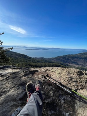
Oyster Dome is a rocky promontory on the western slope of Blanchard Mountain, the grandest member of the Chuckanut Mountain range, an extension of the Cascades that rises directly from the ocean. The sheer cliffs of Oyster Dome offer year-round access to commanding views of the San Juans, Skagit River flats, Olympic Mountains, and Samish Bay (WTA) CHS hike led at a CHS 2 pace (2.0-3.0 mph)
- Wed, Apr 24, 2024
- Seattle Hiking Committee
- Day Hiking
- Adults
- Moderate
- Moderate
- Mileage: 9.5 mi
- Elevation Gain: 1,988 ft
- Pace: 2.0-3.0 mph
- 5 (8 capacity)
- FULL (2 capacity)
- Cancellation & Refund Policy
Meeting Time: 8:00 am, so make sure you come a little bit earlier to be geared up and ready to go! We are meeting early because parking get's busy up there!
We will start hiking no later than 8:15 am, after brief introductions.
Directions to trailhead and parking
Here's the location of the Trailhead: https://www.google.com/maps/search/48.608633,+-122.433302?shorturl=1
The Trailhead is on the east side of Chuckanut Drive, right next to a big yellow bus-loading sign, and a small blue sign that reads 2647. Park along the west side of the road.
Coming from Seattle driving north, you will see a sign for Blanchard Road and a cluster of establishments first, look for parking when you see the yellow bus sign coming into view on your right. You will have gone too far if you see the Oyster Bar on your left.
DISCOVERY PASS is required.
Make sure not to leave any valuable items in your car.
The Oyster Dome trail is a very popular hike that you can read about here. Hiking it mid-week will give us a bit of breathing room, the early start will help too! It is one of my favorite hikes!
Most of the elevation will be hiked in the beginning, it is very steep! Once we are up, we will head to Lily Lake first, then we will head over to Oyster Dome where we will stop for a 15 min lunch break. We will take short breaks to bring our heart rate down, the plan is to stick together as a group!
Oyster Dome
-
USGS Bellingham South
USGS Bow
Trails of the Chuckanut Mountains
Chuckanut Mountain Recreation Map - See full route/place details.
Required Equipment
Ten Essential Systems
- Navigation (map & compass)
- Sun protection (sunglasses & sunscreen)
- Insulation (extra clothing)
- Illumination (headlamp/flashlight)
- First-aid supplies
- Fire (waterproof matches/lighter/candle)
- Repair kit and tools
- Nutrition (extra food)
- Hydration (extra water)
- Emergency shelter (tent/plastic tube tent/garbage bag)
