Trip Report
Lane Peak/Zipper (winter)
Fantastic trip up the Zipper couloir in April (non-Mountaineers party).
- Mon, Apr 3, 2017
- Lane Peak: Zipper & Lovers Lane
- Climbing
- Successful
-

- Road suitable for all vehicles
-
Great shape right now!
Forecast was fantastic- NWAC reported moderate avy danger (loose wet slabs on south aspects and cornice hazards)- freeze overnight with temps in the teens, no recent significant precip, and today's forecast was for a high of 40*F and sun. Got to Longmire a bit too early- 810am- and waited until ranger opened the gate at 845am (twitter said 9am, so we got an extra 15 minutes).
Parked at Narada falls (26*F) and started walking at 920am to the back of the lot where the buildings are (porta potties at TH available), then up the steep slope hugging the trees stepping in deep boot prints to the Stevens Canyon road (completely snowed over and unplowed). Followed the road (snow still very firm, no snowshoes needed yet) until the bend, then followed snowshoe prints down into the woods until the clearing beneath Pinnacle to the left, Denman straight ahead, and Lane to the right. Put on snowshoes and walked through clearings towards Lane, staying on the north side of the river until in line with the west ridge of Denman where a log? crosses the stream and makes a decent snow bridge (thankful for poles for support here). Then headed south and west to Lane, where we stashed our snowshoes and poles at the base of the avy debris field, put on helmets, crampons and alpine harnesses, and pulled out ice tools.
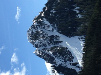
Started up the avy debris field below Lane at 1040am, which at that point was in full sun and overheating commenced (but crampons were necessary as snow was still very firm). At Y between Zipper and Fly couloirs we were back in the shade, but as it was windless, and (guessing) 30*F, it was perfect for climbing. The Zipper had neve and patchy alpine ice (likely not thick/consistent enough for ice screws in most places) with brief patches of 1-3" of snow on top, but perfect conditions for using ice tools and crampons- we had a rope and picket but never used them. Top of couloir by 1240pm.
The snow at the top was all sun exposed and heating quickly, and we went up the wrong gully towards the summit, following boot prints. It is possible to gain the summit ridge here but required very loose rock scrambling for about 10 feet and navigating cornices. The proper gully required traversing a few hundred feet around to the W/SW, then heading up. Snow was getting too soft at this point, so spent almost no time on the summit (cornices everywhere)-110pm- and descended as quickly as we could back down towards the Lane-Denman saddle. Avalanche debris from past slides all over here, but no significant pinwheels yet today, but we continued down quickly- from the saddle, the snow was firmer, and once in the trees, we followed the boot prints to a cliff, then back up and west a bit to the proper gully which required donning crampons again (had removed them on summit snow gully) to descend back to our snowshoes.
Snowshoe out was uneventful, other than we definitely were thankful to have snowshoes as the snow had softened significantly (~2pm then). The hike back up through the trees to the snow-covered road went faster than expected (firm snow). Traversing the road was easy especially with stunning views of Rainier straight ahead, and then a quick glissade down the slope to the car by 330pm.
Strava: https://www.strava.com/activities/927200082
Gear: avy beacons/probes/shovels, 1 picket, 60m 8mm rope, alpine harnesses + belay device, helmets, crampons, ice tools, snowshoes + poles, 2L water, some food...
Photo note: not sure why it is sideways, but it is from today (4/3/17).
 Amanda Silber