Trip Report
Intermediate Snowshoe - Red Pass/Commonwealth Basin
Short trip avoiding avalanche terrain.
- Sat, Mar 11, 2017
- Intermediate Snowshoe - Red Pass/Commonwealth Basin
- Red Pass & Mountain (Commonwealth Basin)
- Snowshoeing
- Successful
- Road suitable for all vehicles
-
Soft snow with a breakable crust made uphill travel slow and down hill travel easy.
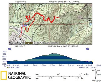
We parked at the Ski area at Snoqualmie Summit and walked through the underpass to cross the highway. Our original plan was to snowshoe along the west side of Commonwealth Basin to the far end, cross the creek and traverse uphill along the PCT on the other side of the basin. Then cross the ridge near Kendall Knob to descend to Kendall Peak Lake as a side trip before descending the west ridge of Kendall Knob. Given the soft snow and the fact that the creek was open and running, we soon revised the plan to skip the tour of the basin and head directly for Kendall Knob. Given the "considerable" avalanche danger (in the below tree level elevation band), we wanted to stick to moderate, forested terrain. We did this by generally following the gentle west ridge, traversing to the climber's right any time the terrain got steep. At about 4000' it started snowing. At 4600' (about 100' vertical from the summit) we stopped for lunch. Several party members continued to the summit on even more moderate terrain. In order to return before the rain started, we decided to also skip the side trip to Kendall Peak Lakes. From our lunch spot, we descended back into the basin via the ascent route, getting good practice plunge stepping in our snow shoes. From there, we followed the well trod path back to the summer parking lot and then back to the road. We experienced moderate rain during the descent but were back to the cars before the predicted heavy rain began.
5 miles, 1700' elevation gain 6 hours car to car.
Equipment carried (*used): avalanche beacon, shovel, probe, ice ax, rain gear*, poles*, snow shoes*
 Barbara Motteler