")
Red Pass & Mountain (Commonwealth Basin)
Hike or snowshoe to Red Pass, scramble Red Mountain or ski tour to Little Lundin in the Alpine Lakes Wilderness near Snoqualmie Pass.
Getting There
Take Exit 52 off of I-90. At the bottom of the exit ramp, turn north and cross under the freeway. In ~100 yards, turn right onto a paved road leading to the Pacific Crest Trail (PCT) Trailhead (3,000 ft).
The summer trailhead is in unplowed during winter. Parking is available in the Summit West Ski Area lot. From there walk under the freeway overpass, then immediately climb up the snowbank and proceed up through the trees.
on the trail
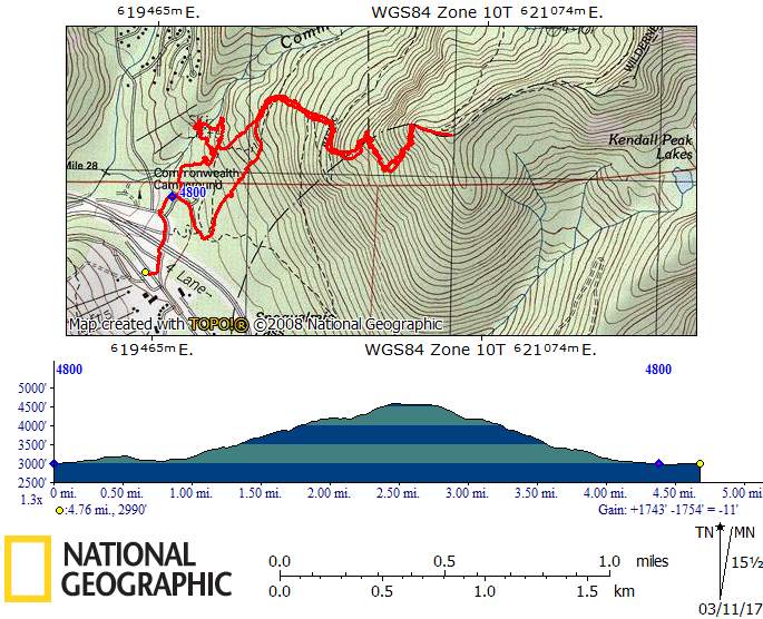
10.0 miles round trip, 2,700 feet of elevation gain, 5,350 ft high point, season: july to october
Hike the Pacific Crest Trail (PCT) 2.5 miles to a fork. Take the left fork and continue to Red Pass (5,300 ft).
snowshoe ROUTE
10.0 miles round trip, 2,700 feet of elevation gain, 5,350 ft high point, Season: December to April
From the freeway, follow old tracks up to the summer PCT trailhead and on to the route of the PCT trail. After about 75 yards, turn left and follow the Cascade Crest (aka Short-cut Trail) that parallels Commonwealth Creek all the way to the back of the Commonwealth Basin and to the base of Red Mountain. From there, follow the route of the summer trail up the steep south ridge, or the more open slopes a bit to the east. Aim for the small tarn shown on the USGS map at 4,800 ft. From there ascend the slope north to the saddle at 5,300 ft.
Backcountry Ski Route
Little Lundin (5,700 ft)
6.0 miles round trip, 2,700 feet of elevation gain, Difficulty: M1 Intermediate Ski
A less traveled moderate backcountry ski tour through Commonwealth Basin and near Red Mountain.
Approach & Ascent
Red Mountain (5,890)
9.0 miles round trip, 2,900 feet of elevation gain, difficulty: Strenuous 3, Technical 2
TK
NOTEs
- In winter, the route up to the base of Red Mountain is fairly safe up to and including “Considerable” avalanche danger. However, the slopes above 4,000 ft are highly susceptible to large avalanches and are typically unsafe in “Considerable” or “High” avalanche danger.
Information for leaders
Permits
As of 2017, the Snoqualmie Ranger District considers Mountaineers trips and courses to be "nominal use". Leaders should print and copy this designation letter to show rangers they may see on trail or carry a digital copy on their phone.
- Suitable Activities: Day Hiking, Scrambling
- Seasons: Year-round
- Weather: View weather forecast
- View avalanche forecast.
- Difficulty: *Varies*, Strenuous 3, Technical 2, Strenuous, Winter Scramble, M1 Intremediate Ski
- Length: 9.0 mi
- Elevation Gain: 2,900 ft
- 5,890 ft
-
Land Manager:
Mount Baker-Snoqualmie National Forest
Alpine Lakes Wilderness, Snoqualmie Ranger District (MBSNF)
- Parking Permit Required: Northwest Forest Pass
- Recommended Party Size: 12
- Maximum Party Size: 12
- Maximum Route/Place Capacity: 12
- Green Trails Snoqualmie Pass No. 207
- Green Trails Snoqualmie Pass Gateway No. 207S
- USGS Snoqualmie Pass
This is a list of titles that represent the variations of trips you can take at this route/place. This includes side trips, extensions and peak combinations. Not seeing a title that fits your trip? Log in and send us updates, images, or resources.
- Red Pass
- Red Mountain
- Red Pass & Mountain
- Little Lundin
- Red Pass (Commonwealth Basin)
- Red Mountain (Commonwealth Basin)
| Name/Description |
|---|
| KendallKnob.JPG |