Trip Report
Intermediate Alpine Climb - Mount Matier/Northwest Face
Great location, both campground and the climb. Getting to the base of climb is more than half the battle for this approach.
- Fri, Aug 19, 2016 — Sat, Aug 20, 2016
- Intermediate Alpine Climb - Mount Matier/Northwest Face
- Mount Matier/Northwest Face
- Climbing
- Successful
- Road suitable for all vehicles
-
There were some concerns given the high temperature that Friday and Saturday. We saw and found ice on the route, though we had to dig through a few inches of bad ice to get to reasonable ice below.
This is my second trip this year where I will recommend against the approach we used. We ended up bivying after a long day... Upper Joffre Lakes campground is a beautiful site, but crowded. Getting up on Upper Matier Glacier requires crossing streams (two members got water in their boots), negotiating rock bands to get past icefall, and dealing with bad snow / crappy ice to get out on glacier.
Joffre Lakes Provincial Park parking lot was a zoo when we arrived at 1PM Friday afternoon. Finding parking spot took some effort, delaying our start. Both main and overflow lots were full. On Sunday, there were huge number of cars parked on the side of the road, in addition to the lots.
Park requires backcountry camping permit ($5/person/night). Permit does not guarantee camp site, but it appears that number issued is limited to ensure camp sites availability - Make online reservation ahead of time. There was a posting at trailhead saying campground was full for both nights, but a few were still available at sundown Friday.
For the ice climb itself, it is steeper than Observation Rock and sustained. Guidebook suggests difficulties comparable to North Ridge of Baker. Scramble to summit and then to edge of NE spur for descent is airy and very exposed. Descent on NE face is also steep. Leader chose to down climb most of it with picket protections. For efficient travel overall, participants need to have strong ice and snow climbing skills.
Approximate times were:
1.5 to 2 hours from trailhead to campground.
4.5 hours from camp to base of climb, of which at least 3 hours were spent negotiating the rock band and looking for a path to get on the glacier.
2 hours to traverse around the bergschrund at base of the NW face (steep, crevassed).
5 hours on face for 5 pitches. Of that total, 2.5 pitches were on ice, rest on snow.
3.5 hours from summit to rock band. The sun had set and team chose to bivy rather than continue descent at this point. If we had chosen the Cerise Creek approach, this might have been avoidable.
3.5 hours from rock band to camp
1 hour to hike out.
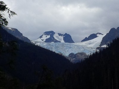
On the attached photo, NW face is visible to the right, NE face descent route on the left. Dark spot on NW face is ice, rest was snow. Icefall in foreground is negotiated to the left, once you are past the rock bands.
 Takeo Kuraishi