Trip Report
Glacier Climb - Little Tahoma/East Shoulder
A challenging late-season climb. The route is still passable but barely.
- Fri, Jul 21, 2017 — Sat, Jul 22, 2017
- Basic Glacier Climb - Little Tahoma/East Shoulder
- Little Tahoma/East Shoulder
- Climbing
- Successful
-

- Road suitable for all vehicles
-
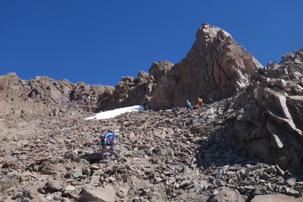
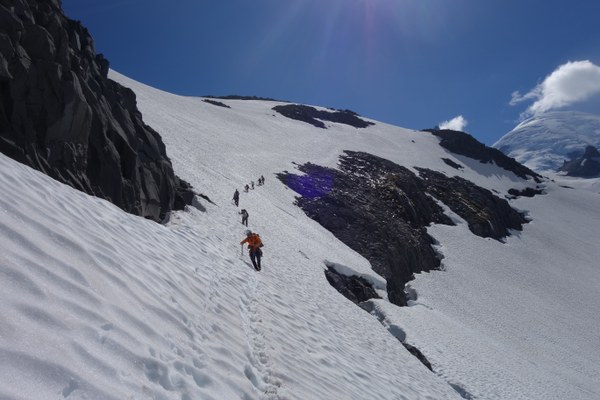
A large moat below camp should be protected and the snow finger won't last long. The upper Whitman glacier has huge sun cups that make ascent slow and exhausting. The rock gully below the summit is nearly snow free. Lots of loose rock and scree. Extremely careful stepping a must!


After picking up our wilderness permit at the White River Ranger Station, a group of 9 of us left the trail head at 9:30 am. We stopped at the first river crossing below the switchbacks for 20 min and then proceeded to Summerland where we left the trail shortly after the group shelter. We found continuous snow on the shoulder of Meany crest, a due South route heading up towards point 7573, our destination for base camp. We stopped again for lunch for about 30 min on a rock tongue in between the snow fields and soon after that we had to make a traverse above a very large rock moat. There is another smaller moat right above it and the finger of snow in between won’t last long. This was one of the sketchiest spot on the route. We ended up protecting it on the way down but in retrospect it would have been better to do so in both directions. We ascended the steep slope above making steps on a zig-zag pattern and we reached camp after 5:48 min from our departure from the trail head. The very large flat rock platform at point 7573 can host a dozen of tents. We were the only group up there and had our pick of the sites including a large very sheltered site between rocks that we used as a kitchen. It turned out there was no wind that night anyways. There is running water about 100 feet south of camp at a fast-moving waterfall so we did not need to melt water. We turned in early to get a few hours of sleep. Clouds moved in around sunset but later in the night the sky completely cleared and we had a perfectly still moonless sky for our 2:15 am departure from camp. We travelled roped up the Frying Pan Glacier navigating without incident in the dark following a previous climb’s GPS track directly to the notch between the Frying Pan and the Whitman glacier. The track lead us exactly where we needed to be despite full darkness made it hard to see it until we were right there. We only encountered one crevasse on our route which we easily skirted around. There were no previous boot tracks to follow and we were glad to have the GPS track to guide us. The notch is rocky and loose but fairly easy to cross over even in complete darkness. Once at the notch we took a short break and we finally saw some light beginning to lighten the sky to the Northeast. Once on the other side we continued to follow the same bearing (~260) traversing the lower portion of the Whitman glacier and going around two major rock formations and gullies before taking a sharp turn (~294) up towards the upper portion of the Whitman Glacier. Here we encountered our first significant crevasse (one of three total on the route). We stayed below and climber’s right of it and started a diagonal ascent almost due north to eventually turn again westward and up aiming at the last snow finger to the left of the glacier. I would say, surprisingly, the crux of the route was this 2000 vertical feet section of the Whitman glacier. It was not only pretty steep (45 degrees +) but mostly it was very hard to ascend due to giant sun cups. Each sun cup was easily as tall as the shortest person in the team and forced us to climb up steps or break edges on it and since the snow was very firm in the morning and there was no previous boot track to follow, it made for slow and exhausting travel. Each of the rope leads took a turn in front and after nearly 3 hours we finally made it to the top of the glacier and reached the rock gully that would lead us to the other side of the summit block. This gully is currently snow-free and composed of very large and loose rock. . It is a bit more solid rock on climber’s right. We went up two at the time. The first two checked conditions on the other side and found almost no snow in the final gully below the summit block determining we could leave crampons and axe behind at the base of the gully. They radioed us this beta and the rest of the group joined them at this second notch two at the time, carefully testing each rock we touched or stepped on. Once on the other side we found lots of loose scree but a faint boot path and after a short ascent on the scree we gained a right trending rock ramp which involved class 3-4 scrambling on mostly firm rock and lead to a second left-angling ramp below the real summit. A bit of scrambling over large boulders took us to the very base of the summit block. There is one airy move that leads to the 30 foot block of rock that is the very tippy top of Little Tahoma. Everyone in the group had very strong rock skills and felt comfortable scrambling it without a fixed rope. I can see how less experienced students may have needed a fixed rope. However given the rock poor quality and scares placements, I am a bit doubtful of its effectiveness in case of a fall. Given the limited space at the summit, we split the group in two and took turns to take pictures and enjoy the bluebird-day views. We carried a rope up in case anyone needed it for descending but again this group of very strong climbers confidently descended back to a large ledge where we ate lunch and enjoyed the views for about an hour. After carefully descending the scree and the rock gully we got back on the glacier, roped up and put our crampons on again. Descending the glacier was a bit easier as snow had softened but no plunge stepping possible on that deeply sun-cupped terrain. We had used pickets on the way up but just re-traced our steps on the way down. Luckily it took us much less time to descend the glacier. We stopped again at the notch between the Fryingpan and the Whitman glaciers for a short rest and then quickly retraced our steps back to camp. We actually took a bit of a higher route on the way back which allowed for a more directly and less steep traverse. We got back to camp at 2:15 pm, exactly 12 hours after we started the climb. After an hour break to re-pack we headed down the steep slope still wearing crampons and using our axes but un-roped. Once we approached the deep moat, we decided it would more prudent to protect the traverse above it as the snow was soft and more slippery at that time of the day. We set up a line of 6 pickets and two ropes, one 40 m and one 30 m (two 40 would have been better) and prusiked along it until safely past the exposed moat. From there we quickly reached the trail at Summerland and after a water-filtering break and snack we headed back to the trail head which we reached 17 hours after the start of the climb in the morning.
Overall, I felt very fortunate to have had such a strong team of leaders and basic climbers and grads. This is in my opinion one of the harder basic climbs, almost on pair with the Fisher Chimneys route on Shuksan I climbed last week. I would say the route is barely in. All reports I read confirmed this is a route better done earlier in the season with more and better snow on the route. The route was very interesting though, camp spectacular and very convenient and views were stunning! A challenging but rewarding basic climb!
 Emma Agosta