Trip Report
Colonel Bob Peak (Pete's Creek)
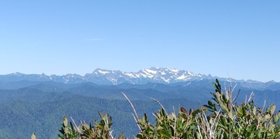
We had clear weather and 360 degree vistas from the summit. Plentiful flowers along the trail. This made for a happy mood in our group. But it was a 3 hour drive to the trailhead and the trail had one washed out section, some blowdowns, and a missing trail junction sign. Trail crews were working on the trail.
- Sat, Aug 6, 2022
- Colonel Bob Peak (Pete's Creek)
- Day Hiking
- Successful
- Road suitable for all vehicles
-
Road was potholed but passable with care. Otherwise the road is flat and wide enough. We saw grouse on the road in the a.m.
We benefited from trail work that was in process this week. There were a few detours to make around blowdowns and washouts.
The summit block, a former lookout site, had steps chopped into the rock on the final few steps.
The Pete's Creek trail to Colonel Bob former lookout site (elev 4492) is approximately 4.2 miles (one way) and 3500 ft elevation gain.
Our party of 4 started hiking up the trail around 8:30 a.m. It was going to be a warm day, in the 80s, but it was nice and cool in the forest and even in the open the still damp vegetation was cool. On top there was a slight breeze and we spent 40 minutes or so before heading down.
Slightly more than halfway up is a trail junction where the Colonel Bob trail meets the Pete's Creek trail. The trail sign is missing as you are going up, so it is easy to miss. On the way down there is a good sign visible nailed up on a big tree.
After the trail junction we reached Moonshine Flats, an area with campsites and a nice creek. There were several tarns which did not look inviting although there were big egg blobs in one tarn, and and hundreds of tadpoles in another!
The final portion of trail winds around before ascending the final rock, which is pillow lava. I looked around fairly diligently for a summit register but didn't find one. There is a USGS marker.
We were happy to have made the summit on such a perfectly clear day. Mount Olympus and its surrounding peaks were visible, along with some of the Baily range peaks, the Quinault lake and river valley below, Mt Rainier, and really it was a bit overwhelming! The ocean was not clearly visible, probably because it blended with the blue sky. Eagles soared overhead.
The surrounding country seen below is very rugged and forested.
I reminisced about doing the Bailey Range Traverse, and thought about the Press Expedition 1889-1890 making their way through the Olympics in the middle of winter to see what was there. They came out the Quinault river valley.
On our way down it was warm but mostly shady. We got back to the trailhead by 2:30. We encountered 6-7 parties coming up, several with dogs. The trail crew was hard at work at the washout area.
I should mention the prolific beautiful flowers we encountered along the trail. Lots of white aster, tiger lilies, fireweed, thimbleberry, lupine, penstemon. I saw a few yellow monkeyflowers, a few red paintbrush, pink heather, alpine spirea. The flowers were abundant but we couldn't name them all. There were some small ripe blue berries.
The silver fir were beautiful as well.
We saw bear scat on the trail in several places but didn't see any bears.
 Shirley Rogers