Trip Report
Alpine Scramble - Hawkins Mountain
This was a fun loop trip with nice views and interesting geology.
- Sun, Oct 7, 2018
- Alpine Scramble - Hawkins Mountain
- Hawkins Mountain
- Scrambling
- Successful
- Road suitable for all vehicles
-

Trip Date: October 7, 2018
Party Size: 6
7 AM - Met at the Preston P&R
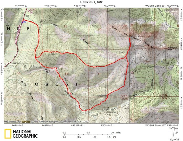
Parked in a pullout along FS 4330 about 100' south of the 4330-13 spur road, which is just south of Camp Creek. There is a convenient turn-around at the 4330/4330-13 junction.
9:30 AM - started hiking from FS 4430
Ascended the W-SW ridge of Hawkins Mountain roughly along what is shown as trail #1228 on CalTopo. We used helmets below point 4,472 (shown on USGS Topo). Staying well left of Point 4472' avoided most of the loose rock and allowed for easier travel.
Above Point 4472' we enjoyed a pleasant ridge run with expansive views. There were patches of snow starting around 6,000 and above, but not enough to cause any difficulties. We scrambled just below and climber's left of the false summit, then over to the actual summit with trekking poles (class 2). Taking the easiest route, as we did, I'd call this T2 rock, but you could definitely make this T3 if more fun is desired. Cap for Mountaineer's metal cylinder summit register does not screw on tight (ie may leak). New summit register is needed (currently contains loose pieces of dry paper).
Summit: 2:10 to 2:30 PM
We descended our ascent route until about elevation 6500' where the two ridges meet. We descended the S-SW ridge to make a loop trip. This descent route provided new views and passed interesting geological features both along the ridge and along the additional bit of trail.
Cars: 6:20 PM
Trip stats via GPS track taken: about 9 miles, 3980' gain
 Carolyn Graham