Steens Mountain Loop
A very remote and strenuous but spectacular bikepack route that climbs 7,000 feet to the top and descends on the backside of Steens Mountain in southeast Oregon.
Getting There
On the Trail
This mostly gravel, remote and high-altitude bikepacking route starts and ends at the Frenchglen Hotel near Burns, OR. It is a 72 mile clockwise loop that climbs 7,300 feet to the summit of Steens Mountain on the north side and descends on the south side. A 10-mile paved section of US-205 connects the two sections. 85% of the route is on gravel roads and 15% is on paved surface. The grade is mostly 6% with some short sections of 11-15%. Gravel bikes with 45mm+ tires (or mountain bikes) are strongly recommended.
Views from the lookout viewpoints and from the summit of Steens Mountain to the bottom of the Alvord Desert are astounding! Steens Mountain is the largest Fault-Block Mountain in North America. Amazing geology and wildflowers (in early summer) will keep you distracted from the hard effort on this 6,000-foot climb. Kiger mustangs, antelopes, coyotes, and many species of birds of prey may also be spotted on this remote route.
The climb is relentless right from the start climbing 6,100 feet in the first 31 miles to the summit of Steens Mountain. Along the way, Fish Lake Campground at mile 16.5 provides an opportunity for a break and some rest. Water is also available here. Pressing on past Fish Lake campground the slope gets steeper and the terrain becomes more diverse and scenic.
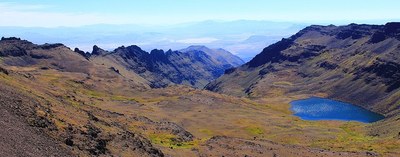
The first view point a ¼-mile detour to Kiger Gorge, a very deep canyon running north and south. The second view point is the East Rim which requires a ½-mile steep climb. The third and best viewpoint is from the true summit. It provides a fantastic view of Wildhorse Lake and the Alvord Desert but requires a 2.5-mile and super steep detour, but it is not be missed.
After reaching the true summit at mile 29, the gravel roads drops 4,100 feet in ten miles. It's imperative to have fresh brake pads for this trip. At mile 43 is South Steens Campground, the recommended place to camp if planning this trip in 2 days. If the plan is 3 days, Fish Lake or Jackman Park campgrounds could be chosen for day 1.
Upon reaching the bottom of the road, dry forest land and open grazing areas alternate on an undulated terrain with a few short hills. At the intersection with US-205, take a right (north) and head back to Frenchglen. This is a 10 mile stretch of paved road which starts with a 2 miles slight uphill and ends with 8 miles downhill to the start point.
Camping & Water
- Mile 16.5: Fish Lake campground
- Mile 18.5: Jackman Park campground
- Mile 43: South Steens campground
Field Guides
- GeologicTrips.com
- USGS Geologic Field Trip Guide to Steens Mountain Loop Road
- Wildflower Guide of Steens Mountain
Notes
- This route is for experienced bikepackers with excellent physical conditioning. At a minimum, participants should have completed a number of prior bikepacking trips and be accustomed to very long climbs with a weighted bike.
- Suitable Activities: Bikepacking
- Seasons: June, July, August, September
- Weather: View weather forecast
- Difficulty: Bikepacking Gravel IV, Bikepacking Gravel V
- Length: 72.0 mi
- Elevation Gain: 7,319 ft
- 9,686 ft
- Land Manager: Steens Mountain Cooperative Management and Protection Area
- Parking Permit Required: None
- Recommended Party Size: 6
- Maximum Party Size: 12
- Maximum Route/Place Capacity: 12
This is a list of titles that represent the variations of trips you can take at this route/place. This includes side trips, extensions and peak combinations. Not seeing a title that fits your trip? Log in and send us updates, images, or resources.
- Steens Mountain Road Loop
| Name/Description |
|---|
| Dirty Freehub Map & Guide A Dirty Frrehub map, GPS route, and guide for the Steens Mountain Road Loop published Jul 2018. |
