Resources
Seattle Olmsted 50 Map
A map of the Seattle Olmsted 50 route done in GAIA GPS by Peter Hendrickson Oct 2023.
![]() Sea Olm 50 Sec Map 17oct23.pdf
— 840.2 KB
Sea Olm 50 Sec Map 17oct23.pdf
— 840.2 KB
Seattle Olmsted 50 GPX File
A GPX file of the Seattle Olmsted 50 route by Peter Hendrickson Oct 2023.
![]() SeaOlm50-all-17oct23.gpx
— 375.3 KB
SeaOlm50-all-17oct23.gpx
— 375.3 KB
Seattle Olmsted 120 Entire Circuit Map Image
A map of the entire Seattle Olmsted 120 circuit with segment junction markings.
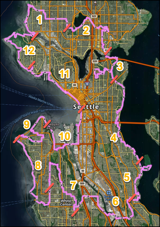 Olmsted120.png
— 869.9 KB
Olmsted120.png
— 869.9 KB
Seattle Olmsted 120 Entire Circuit GPX File
A GPX file for the entire Seattle Olmsted 120k circuit
![]() SeaOlm70-50-16may2024.gpx
— 1018.9 KB
SeaOlm70-50-16may2024.gpx
— 1018.9 KB

Seattle Olmsted 50 Section 1 Resources
Starts at the Ballard Locks then goes to Golden Gardens, and finishes at Woodland Park Zoo. It's 5.9 miles one-way with 526 feet of elevation gain (9.4 km with 159 m of elevation gain). Loop Option to Golden Gardens and return is 8.7 km (5.4 mi), 133 m (439 ft) elevation gain.

Seattle Olmsted 50 Section 2 Resources
Starts at Woodinville Park Zoo and then goes to Green Lake, Cowen/Ravenna Parks, Ravenna Boulevard, and finishes near Husky Stadium. It's 6.4 miles one-way with 362 feet of elevation gain (10.3 km with 110 m of elevation gain). Loop Finish Option to Green Lake and return is 7.9km (4.9 mi), 109 m (360 ft) elevation gain.

Seattle Olmsted 50 Section 3 Resources
Starts near Husky Stadium then goes to Marsh & Foster Islands, The Arboretum, Interlaken Park, Volunteer and Louisa Borken Parks, and finishes at Washington Park Playfield. It's 6.7 miles one-way with 650 feet of elevation gain (10.7 km with 197 m of elevation gain). Another 75 feet of elevation gain gets you to the views atop the Volunteer Park Water Tower. Loop Finish Option to lower Interlaken Park and return is 6.6 km (4.1 mi), 130 m (429 ft) elevation gain.

Seattle Olmsted 50 Section 4 Resources
Starts at the Washington Park Playfield then goes to Lake Washington Boulevard, Denny Blaine, Viretta, Howell, Madrona, Leschi, Frink, Colman and Mount Baker Parks, and Hunter Boulevard, and finishes at Stan Sayres and Genesee Parks. It's 6 miles one-way with 585 feet of elevation gain (9.7 km with 177 m of elevation gain). Loop Finish Option to Madrona and return is 7 km (4.7 mi), 171 m (564 ft) elevation gain.

Seattle Olmsted 50 Section 5 Resources
Starts at Stan Sayres Memorial Park and Boat Launch then goes to Lake Washington Boulevard, Seward Park, Martha Washington Park, Pritchard Island Beach, Rainier Beach Urban Farm, Be'er Shiva Park, and finishes at Rainier Beach Playfield . It's 6.8 miles one-way with 445 feet of elevation gain (10.8 km with 139 m of elevation gain). Loop Finish Option to Seward Park and return is 6.6 km (4.1 mi), 136 m (449 ft) elevation gain.

Seattle Olmsted 70 Section 6 Resources
Starts at Rainier Beach Community Center (beside the Playfield) then follows the Chief Sealth Trail before crossing over I-5 and the Duwamish River towards South Park. The trail continues under Hwy99 then over SR509 by bus or on foot to White Center and Dubsea Coffee in Greenbridge. Much of the route follows the path of the Olmsted’s unrealized Dunlap Canyon Parkway. It’s 7.3 miles one-way with 767 feet elevation gain (11.7km, 234 m of elevation gain). Loop Finish Option to MLK Jr intersection and return 6.1 km (3.8 mi), 94 m (310 ft) elevation gain.

Seattle Olmsted 70 Section 7 Resources
Starts in the Greenbridge Neighborhood through Westcrest and Highland Parks before moving through the Longfellow Creek Natural Area to Greg Davis Park. Elevation is regained to and through Camp Long, site of the CCC built Schurman Rock where legendary Mountaineers trained. The route finishes south down 35th Avenue SW along the unrealized South Bourne Parkway to Myrtle Reservoir Park and Seattle’s High Point, elevation 520ft. It’s 6 miles one-way with 529 feet elevation gain (9.6 km, 162 m of elevation gain). Loop Finish Option to Delridge Way and return 7.2 km (4.4 mi), 66 m (317 ft) elevation gain.

Seattle Olmsted 70 Section 8 Resources
Starts at High Point between the two standpipes and heads through Fauntleroy Park past Captain’s Park and the Fauntleroy Ferry Terminal to Lincoln Park. The Bruun Idun Troll greets shoreline walkers on their way to Lowman Beach Park. Passing Me-Kwa-Mooks Park near the unrealized Sound Bluffs Parkway, the route pauses in Constellation Park to end at the Coast Guard Alki Point Lighthouse. It’s 6.9 miles one-way with 143 feet elevation gain (11.1 km, 44 m of elevation gain). Loop Finish Option to Lincoln Park and return 8.3 km (r.1 mi), 250 m (825 ft) elevation gain.

Seattle Olmsted 70 Section 9 Resources
Starts at Alki Point and passes along Alki Beach Park and Alki Playground before entering Schmitz Boulevard and Schmitz Preserve Park where old growth trees are yet found. Crossing over the unrealized West Seattle Parkway, the route leads to Hiawatha Playfield, an Olmsted city park. The route finishes down sets of little known stairs to walk along the beach via the intended Duwamish Head Parkway at the Seacrest Park Foot Ferry Terminal. It’s 5.3 miles one-way with 425 feet elevation gain (8.6 km, 130 m of elevation gain). Loop Finish Option to Schimitz Preserve Park and return 7.1 km (4.4 mi), 134 m (442 ft) elevation gain.

Seattle Olmsted 70 Section 10 Resources
Starts at the Seacrest Foot Ferry Terminal and heads south, on the Alki Trail past Jack Block Park to the Dragonfly Pavilion and Gardens and Salmon Bone Bridge in the Longfellow Creek Greenspace. The trail climbs stairs and sidewalks to Pigeon Point in the West Duwamish Green Belt then down to pass over the Duwamish River on the Spokane Street Bridge. This maritime industry walk finishes near the Pioneer Square Habitat Beach and Seattle Foot Ferry Terminal. It’s 5.9 miles one-way with 340 feet elevation gain (9.5 km, 104 m of elevation gain). Loop Finish Option to Longfellow Creek and return 8 km (5 miles), 184 m (607 ft) elevation gain.

Seattle Olmsted 70 Section 11 Resources
Starts at the Seattle Ferry Terminal and celebrates public art installations through downtown past Hammering Man to the Pike Place Market and the Olympic Sculpture Garden. Myrtle Edwards Park leads past more sculptures to the Terminal 86 Grain Facility, then passes over the Magnolia Bridge to the Elliott Bay Marina below the Admiral’s House high on the bluff. A concealed path leads to Hidden Beach street end and then to the Magnolia Village Pub. It’s 6 miles one-way with 352 feet elevation gain (9.6 km, 107m of elevation gain). Loop Finish Option to Myrtle Edwards Park and return 5.5 km (3.4 mi), 126 m (416 ft) elevation gain.

Seattle Olmsted 70 Section 12 Resources
Starts in Magnolia Village and runs along the Magnolia Boulevard W where great views lead to a long stairway down to Perkins Lane (where houses have slid into the Sound). The trail rises to Discovery Park to again follow the bluff until finding the West Point Lighthouse. A switch backed trail leads back into the heart of Fort Lawton passing Daybreak Star on the way to Commodore Park and the Ballard Locks, to complete the 120km circuit. It’s 6.7 miles one-way with 779 feet elevation gain (10.8 km, 237m of elevation gain). Loop Finish Option to Perkins Lane and return 7.6 km (4.7 mi), 234 m (772ft) elevation gain.