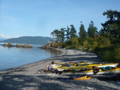
San Juan Islands & Lummi Island from Gooseberry Point
Sea kayak around an island not frequently visited by power boaters. The southern end is rugged and hosts a Cascadia Marine Trail campsite. Southerly winds can create rough paddling conditions with an opposing current, and there are moderate currents on the east side of Lummi Island and Rosario Strait to the west. Or paddle from Gooseberry Point into the islands in the San Juan Archipelago.
launch points
- Gooseberry Point, Lummi Nation. The launch is north of the Lummi Island Ferry and the land is owned by the Lummi Nation. This is a commercial business servicing the Lummi fishing industry. A parking attendant is in the shack next to the boat launch. Their phone is (360)305-9703—call ahead if you have questions about current status. It's best to park in the western most corner of the lot and launch from the nearby gravel beach. This parking lot is monitored by a security guard and costs $5/night as of 2020. Parking is also available in the ferry parking lot—drive Lummi View Drive east from the ferry to find street side parking along the south side.
- Wildcat Cove, Larrabee State Park
- Lummi Island (includes a short ferry ride)
- See San Juan Islands from Anacortes and Padilla Bay & Nearby Islands for other nearby launch points and paddling destinations in the San Juan Islands. Gooseberry Point has the closest access to the northern San Juan Islands. Crossing to the San Juan Islands often includes a brief stop on Lummi Island on an open beach ~0.5 nm from the northern tip on the western coast. Crossing Rosario Strait should include precautions for currents and boat traffic—check in with Vessel Traffic Service.
On the Water
Lummi Island Circumnavigation
19 nm round trip, difficulty: sea kayak II/III
Paddle around one of the San Juan Islands that is not frequently visited by power boaters. The southern end is rugged and hosts a Cascadia Marine Trail campsite. Southerly winds can create rough paddling conditions with an opposing current, and there are moderate currents on the east side of Lummi and Rosario Strait to the west.
Gooseberry Point to Clark Island
14 nm round trip, difficulty: Sea Kayak IV
Sea kayak to the 55-acre Clark Island Marine State Park with saltwater shores, beach campsites and picnic areas, sandy beaches and pea gravel beaches. Be sure to check out the intertidal areas along the southern end of the island or find one of the several benches along the bluffs to watch the sunset and take in a view of Mount Baker and Lummi Island.
- There are 15 campsites all along the eastern shore and a handful of picnic areas along the western shore.
- There are 11,292 feet of saltwater shoreline on the Strait of Georgia.
- The beaches are sandy on the west side of the island and smooth pea gravel on the east side.
- There are two composting toilets on the island, but no running water.
Eliza Island
10.2 nm round trip, Difficulty: Sea Kayak III+
Eliza Island near the south end of Lummi Island in Bellingham Bay. From Larrabee State Park the crossing to the island is ~3.6 nm. The only public landing spot on Eliza Island is at the very south tip of the island—the shore there is rocky and exposed. As an alternative to landing on the island, continue across to the water trails campsite on Lummi Island.
Portage Island
8.5 NM Round Trip, Difficulty: Sea Kayak II/II+
Paddling around this island just off of Bellingham is only possible at about a 5-6 foot tide. At lower tides it is possible to drive across the "portage" to the island.
San Juan Islands Archipelago
Visit our San Juan Islands from Anacortes route/place for more information about island paddling destinations in the San Juan Islands Archipelago that may be reached from Gooseberry Point.
Information for Leaders
scheduling
This route allows multiple bookings. Please check scheduled trips listed below in the "Activities" tab to see if there is another group already booked on the same day. If so, please coordinate with them to ensure you are carpooling and heading to different locations at different areas. Please keep groups to two per launch point.
permit information
The Mountaineers has a commercial use permit with Washington State Parks for all free and fee-based outings at state parks. Leaders should carry a print or digital copy of our commercial use permit to show rangers they may encounter.
- Suitable Activities: Sea Kayaking
- Seasons: Year-round
- Weather: View weather forecast
- Difficulty: *Varies*
- Land Manager: Land Manager Varies
- Parking Permit Required: see Land Manager
- Recommended Party Size: 8
- Maximum Party Size: 12
- Maximum Route/Place Capacity: 12
- Sea Trails Lummi Island, Bellingham & Samish Bays WA005
- NOAA Bellingham to Everett No. 18423
- NOAA Strait of Juan de Fuca to Strait of Georgia No. 18421
- NOAA Bellingham Bay No. 18424
This is a list of titles that represent the variations of trips you can take at this route/place. This includes side trips, extensions and peak combinations. Not seeing a title that fits your trip? Log in and send us updates, images, or resources.
- Lummi Island Circumnavigation
- Gooseberry Point to Clark Island
- Clark, Patos, Sucia & Matia Islands
- Eliza Island
- Northern San Juan Islands
- Portage Island
- Portage Island Circumnavigation
- San Juan Islands Archipelago
- San Juan Islands Archipelago Circumnavigation
There are no resources for this route/place. Log in and send us updates, images, or resources.
