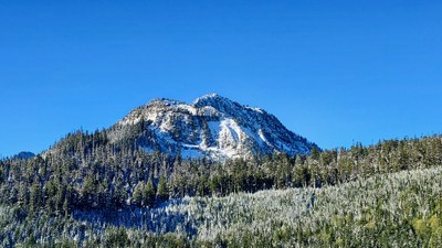
Round Mountain
A scramble near Darrington that is a good winter route when you can drive a few miles of the Forest Road 1890. The route is usually 6 miles round trip and 3,400 feet of elevation gain. Despite it's modest altitude, Round Mountain ranks as the eighth most prominent mountain in Washington, and as such it, enjoys commanding views.
Getting There
The most practical and shortest approach is from Swede Heaven. Drive SR-530 to ~24 miles east of Arlington or ~5 miles west of Darrington. Turn north onto Forest Road 1890 and drive across the North Fork Stillaguamish River. When the road bears west, take the second main turnoff on the right. Drive this logging road as far as possible. It ends in ~4 miles (2,000 ft).
APPROACH & ASCENT
From the second clearcut, ascend up steep, forested slopes; staying right and below the ridge that leads to the East Ridge of Mount Higgins. At ~3,800 ft, climb to the crest of a forested ridge that lies north and parallels the ridge leading to Mount Higgins. Follow this ridge northwest, descending a bit as it turns north heading to the south flank of Round Mountain. The final climb is up snow with scattered trees and rock outcrops. It takes ~4 hours and there is typically little to no avalanche hazard.
- Suitable Activities: Scrambling
- Seasons: Year-round
- Weather: View weather forecast
- View avalanche forecast.
- Difficulty: Winter Scramble
- Length: 6.0 mi
- Elevation Gain: 3,400 ft
- 5,320 ft
-
Land Manager:
Mount Baker-Snoqualmie National Forest
Darrington Ranger District (MBSNF)
- Parking Permit Required: None
- Recommended Party Size: 12
- Maximum Party Size: 12
- Maximum Route/Place Capacity: 12
- Green Trails Mountain Loop Highway No. 111SX
- USGS Mt Higgins
There are no resources for this route/place. Log in and send us updates, images, or resources.
