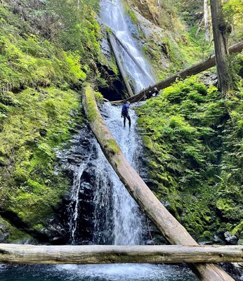
Murhut Creek
Murhut Creek is a sizeable tributary of the Duckabush River located on the east side of Olympic National Forest near the north end of Hood Canal. The canyoning route encompasses the bottom of the creek, from Murhut Falls down. It is rated 3CIII.
GETTING THERE
Drive US-101 to 56 miles north of Olympia. After passing over the Duckabush River turn left onto Duckabush Road and drive 6.3 miles. Shortly after crossing over the Duckabush Road Bridge there is a dirt road junction. Continue straight/right onto Forest Road 2530 and drive 1.2 miles to the Murhut Falls Trailhead. If doing the shuttle, leave a vehicle at the bridge and be sure to assess the flow level in the river.
From points north it is also possible to take the ferry from Edmonds to Kingston, drive US-104 east to US-101 and then drive south to the Duckabush Road.
APPROACH
From the trailhead, follow the signed trail 0.8 miles to Murhut Falls. Hike to the top of the falls by heading up the steep wooded slopes behind the upper viewpoint. Bear gradually right gaining elevation until well above the falls, an easy ascent Head downhill through open forest to the creek just upstream of the waterfall.
DESCENT
- Rappel 1: 130 feet (DCL, Down Canyon Left). An awkward hanging start from a small cave at the bottom of the falls. Rappel 1 & Rappel 2 comprise Murhut Falls. Be sure to check that the coast is clear if throwing rope/rope bag, because there may be hikers at the bottom of the falls.
- Rappel 2: 30 feet (Log, DCR, Down Canyon Right). A retrievable anchor system is encouraged as these fall are in sight of the trail. Or bypass on steep trail DCL. The viewpoint on the trail is just below Rappel 2. Next enjoy the creek walk downstream and two small waterfall downclimbs DCR.
- Rappel 3: 50 feet (Tree, DCL). Two-tier, 25 feet and 10 feet, with a large strainer in-between. In high water there may be a hydraulic at the bottom of both drops. The very bottom is a short narrow corridor with a boulder choke that can form a siphon. If flow is high, there is a bypass by scrambling up a dirty chute DCR and rappelling from a large tree (60 feet).
- Rappel 4: 40 feet (Tree, DCL). Low angle rappel.
- Rappel 5: 80 feet (Tree, DCR).
- Rappel 6: 15 feet (Knob, DCR). In high flow, there is a possible hydraulic in the landing zone. It can be bypassed DCR. A very technical jump may also be an alternative (check depth first).
- Rappel 7: 20 feet (Tree, DCR). A thick logging cable buried in the logjam can also be used as an anchor. The next section involves several small waterfalls that can be downclimbed, slid, or jumped. Check water levels before jumping.
- Rappel 8: 50 feet (Tree, DCL). The tree is near the edge and not the strongest looking. A meat anchor recommended. It is possible to exit DCR up onto the ridge.
EXIT
The exit can be done either as a 1-mile hike/bushwack with 300 feet of elevation gain, or by floating and creek walking 0.6 miles down the river.
Hike/Bushwack: From the confluence of Murhut Creek and the Duckabush, exit the canyon DCR. Bushwhack up the slope, trending southeast. Ascend the slope for about 200-300 feet above the river until reaching an old logging road grade. Follow this mostly level grade east about 5-10 minutes until it intersects Forest Road 2530. The grade is overgrown, but there is game trail running along it. Walk up the road 0.3 miles to the Murhut Falls Trailhead.
River Float/walk: If doing the shuttle option, float/creek-walk 0.6 miles down the Duckabush River to the bridge. This likely takes more effort, however. Use caution in the early season when the Duckabush may be running high.
EQUIPMENT
Standard canyoning gear including replacement webbing and quick links.
TRIP PROFILE
- Rappels: 9
- Longest Rappel: 130 feet
- Approach: 0.8 mile
- Exit: 1 mile (0.6 mile with shuttle)
- Time: 6-8 hours total
CAMPING
There are several campgrounds nearby, including Collins Campground on Duckabush Rd Extended, Dosewallips State Park off US-101, and Seal Rock Campground off US-101. There are numerous primitive camping spots along Forest Road 2510 and Forest Road 2530—some may accommodate up to 8 vehicles.
Notes
- See ropewiki.com's Murhut Creek web page for up-to-date beta.
- This canyon can be combined with nearby Fulton Creek for a weekend of canyoning adventures on the east side of the Olympic Peninsula.
- Suitable Activities: Canyoning
- Seasons: June, July, August, September
- Weather: View weather forecast
- Difficulty: Basic Canyon
- Length: 2.2 mi
- Elevation Gain: 300 ft
- 1,180 ft
- Land Manager: Olympic National Forest
- Parking Permit Required: Northwest Forest Pass
- Recommended Party Size: 7
- Maximum Party Size: 12
- Maximum Route/Place Capacity: 12
There are no resources for this route/place. Log in and send us updates, images, or resources.
