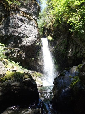
Fulton Creek
A short, beautiful Basic Canyon in the Hoodsport area. It's rated v3a3II at moderate-low water levels, and v3a4II in early to mid-season.
GETTING THERE
Just north of Triton Cove State Park, turn left off SR-101 onto Seamount Dr. Follow the road upwards for 2 miles to Junction 969 where there's room for several cars. Note that the road gets rough after the end of pavement for a short distance; passenger cars should be driven carefully. At the T-intersection, leave one car at a pull-out on the right. This is the exit car. The rest of the vehicles, a maximum of three, should turn left, and follow the road almost to the end. Just before the end of the road is a berm/mud pit that normal vehicles won't be able to pass. There is room for about three cars to park on the side of the road just before the berm.
APPROACH
From the junction, walk down the road to the creek. There's a small campsite at the end of the road. Just before the campsite, look left to find a motor bike trail leading down to the creek.
DESCENT
- Rappel 1: 60 feet DCL (Down Canyon Left) from 2 unlinked bolts.
- Rappel 2: 100 feet from webbing around a log in the center of the creek. There is a small pool as part of this rappel.
- Rappel 3: 100 feet DCR (Down Canyon Right) from webbing around tree. It is recommended to build a traverse line to access the tree. Be sure to test that the tree is a solid anchor as the some of the roots are exposed on the rock. This is a 2-stage rappel with a pool in-between. A 60m rope just barely reaches so make sure to set the rope length well or have a pull cord. There is a log in the watercourse on the second tier which is very easy to avoid on rappel, however take care when pulling your rope as it can get caught around it.
- There is a 15 foot down climb through a mini-slot shortly after Rappel 3.
A short distance further down canyon is a large logjam. Rappel or downclimb. Check out the cool boulder cave underneath the log jam on the DCR side of the creek.
EXIT
Below the log jam, keep going until it gets easy to climb out of the creek DCL. If it's steep and brushy, you are in the wrong place. A small cairn marks the exit. Head up into a shallow draw and head uphill on game trails to the canyon rim (~300 feet of elevation gain). The going is relatively easy until you enter the old clear cut at the top. Getting back to the road is the worst bit and requires walking on decomposing logs, wading through slash, grabbing bunches of vegetation for stability, and bushwhacking. Once you intersect the road, walk back up to your car (~2 min).
EQUIPMENT
Standard canyoning gear including webbing, a wrench and replacement quick links.
TRIP PROFILE
- Rappels: 3-4
- Longest Rappel: 100 feet
- Approach: ~ 500 feet
- Exit: ~0.5 mile
- Time: 3-4 hours total
NOTES
- This canyon is rated v3a3II at moderate-low water levels, and v3a4II in early to mid-season.
- For more information and recent trip reports from the community, visit the Fulton Creek listing at ropewiki.
- Suitable Activities: Canyoning
- Seasons: July, August, September
- Weather: View weather forecast
- Difficulty: Basic Canyon
- Length: 1.0 mi
- Elevation Gain: 310 ft
- Land Manager: Olympic National Forest
- Parking Permit Required: None
- Recommended Party Size: 6
- Maximum Party Size: 8
- Maximum Route/Place Capacity: 8
- Green Trails Olympic Mountains East No. 168S
- USGS Mt Jupiter
- USGS Brinnon
- Custom Correct Brothers - Mt Anderson
There are no resources for this route/place. Log in and send us updates, images, or resources.
