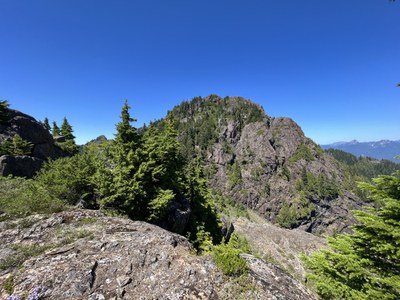
Mount Hoquiam
A classic, low elevation, and moderate Olympic Mountains scramble. It has substantial travel on a boot path and trail that is quite good followed by a brush bash along the ridge to the summit. There are some Class 3 spots along the ridge, but the exposure is moderated by the heavy forest. It's 6 miles round trip 2,000 feet of elevation gain.
Getting There
From US-12 just west of Montesano, drive north on Wynoochee Valley Road 35 miles to Lake Wynoochee. Continue past the lake to the point where Forest Road 2270, a loop road, joins itself. Continue on the east side of the Forest Road 2270 loop for 9.4 miles to an intersection with the abandoned Forest Road 560 (3,300 ft) located on the divide between Chikamin Creek and West Branch Wynoochee River. Park here.
Notes
- Forest Road 2270 is a loop road but, based on a reconnaissance drive in May 2022 the west side of the loop is closed by landslides. Do not take the western loop without first verifying its status.
Approach & Ascent
Follow the boot path on the north side of Forest Road 560 at a small tributary about 100 ft from where Forest Road 560 crosses Chikamin Creek. As the use trail leaves Forest Road 560, it follows the tributary, sometimes directly in the stream, northwest to 3,520 ft where it abruptly turns southwest, then rises slightly to the south end of a chain of meadows at 3,600 ft. The boot path then follows the eastern edge of the meadows to 3,760 ft where it turns northeast and then north into a saddle (4,250 ft) that is northeast of Point 4520. The boot path then descends directly into the meadows on the east side of Mount Hoquiam’s south ridge, ending on the east side of the saddle that is south of Point 4640.
The saddle (4,200 ft) south of Point 4640 is where the scramble starts in earnest. Leave the saddle and follow the ridge north towards Point 4640. There is a large gendarme near 4,360 ft that can be by-passed on the east side. Just before the summit of Point 4640, leave the ridge to the right and climb onto a bench east of the summit. The scramble between the saddle at 4,200 ft and this point is slightly more challenging than the final approach.
From the bench, choose the best route available and descend onto a large, bare rock bench that surrounds the north and east sides of Point 4640. Follow the bench almost directly into the saddle (4,520 ft) that is south of Mount Hoquiam. Ascend northward, staying directly on the ridge. At 4,600 ft there is a gendarme that can be passed on the right. All of the Class 3 moves on this route are located between this gendarme and 4,680 ft, so there's only this short stretch of Class 3, and the heavy vegetation helps to negate much of the feeling of exposure.
Leave the ridge near 4,680 ft, enter open meadows, and begin a rising traverse toward a broad gully that rises to the summit. The gully can be entered by passing directly under a small rock buttress on its western side. The rising traverse and the final slope up to the summit are characterized mostly by heather and grasses with some widely interspersed talus. Within 100 to 200 feet of the summit there are some rock slabs that might offer a route. But it is better to bypass the slabs and stay in the center or left-center of the gully. Stay left as the summit ridge to avoid reaching the east side of a small rock fin that would have to be scrambled down before ascending up to the true summit.
Notes
- Expect extremely thick vegetation on the two ridge climbs. Safety glasses are advisable.
- Allow for at least 4 hours up from Forest Road 560.
- Suitable Activities: Scrambling
- Seasons: July, August, September, October
- Weather: View weather forecast
- Avalanche Terrain Rating Challenging
- Difficulty: Strenuous 3, Technical 3
- Length: 6.0 mi
- Elevation Gain: 2,000 ft
- 4,909 ft
- Land Manager: Olympic National Park
- Parking Permit Required: None
- Recommended Party Size: 6
- Maximum Party Size: 12
- Maximum Route/Place Capacity: 12
- USGS Mount Hoquiam
- USGS Wynoochee Lake
- Green Trails Mt Christie No. 166
- Custom Correct Quinault-Colonel Bob
There are no resources for this route/place. Log in and send us updates, images, or resources.
