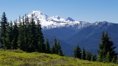
Excelsior Peak via Damfino Lakes
A moderate hike of 6.5 miles round trip with 1,500 feet of elevation gain northwest of Mount Baker. Enjoy flower-filled meadows and views of Mount Baker. Considering extending your journey on the East High Divide Trail going as far as Welcome Pass.
Getting There
Drive 1.8 miles east on SR-542 from the Glacier Public Service Center, turn left onto Forest Road 31 (Canyon Creek Road), and drive 16.7 miles to its end and the Damfino Lakes Trailhead with parking for ~15 cars (4,250 ft). Note that parts of the road are paved, parts are rough with large portholes and deteriorating pavement, and parts are good gravel and dirt surface.
On the Trail
Hike the Damfino Lakes Trail 0.7 mile to Damfino Lakes and continue 2.2 miles to Excelsior Peak. For those wanting more mileage and adventure, consider hiking the East High Divide Trail going as far as Welcome Pass.
Notes
- Backpackers may need to carry water to camp from last stream crossing a half mile before the ridge.
- Suitable Activities: Backpacking, Day Hiking
- Seasons: July, August, September
- Weather: View weather forecast
- Difficulty: Easy/Moderate
- Length: 6.5 mi
- Elevation Gain: 1,500 ft
- 5,699 ft
-
Land Manager:
Mount Baker-Snoqualmie National Forest
Mount Baker Ranger District (MBSNF)
- Parking Permit Required: Northwest Forest Pass
- Recommended Party Size: 12
- Maximum Party Size: 12
- Maximum Route/Place Capacity: 12
- Green Trails Mount Baker Wilderness Climbing No. 13SX
This is a list of titles that represent the variations of trips you can take at this route/place. This includes side trips, extensions and peak combinations. Not seeing a title that fits your trip? Log in and send us updates, images, or resources.
- Damfino Lakes
- Excelsior Peak & East High Divide
- Excelsior Peak & East High Divide via Damfino Lakes
- Welcome Pass
- Welcome Pass via Damfino Lakes
There are no resources for this route/place. Log in and send us updates, images, or resources.
