Trip
Day Hike - Dosewallips River Road Trail
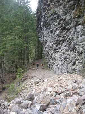
Dosewallips river road and a few miles of the trail. Spring in the Olympics is a riot of greens and the Dose falls will be roaring. Road section is rapidly turning into a very pleasant trail. Come for the flowers, the pillow basalt cliffs, the roaring falls.
- Sat, May 18, 2024
- Seattle Hiking Committee
- Day Hiking
- Adults
- Moderate/Strenuous
- Moderate
- Mileage: 13.0 mi
- Elevation Gain: 1,300 ft
- Pace: 2-2.25 mph
- 12 (11 capacity)
- Cancellation & Refund Policy
End of the Dosewallips road at 0800.
My goals for this trip are as follows:
1. Be safe.
2. Get a good workout.
3. Make to Dose Forks camp, possibly a mile further to the bridge over the river.
My expectations for trip participants:
1. Practice Leave No Trace principles
2. Be respectful of all participants.
3. Have the physical conditioning necessary for this trip. The road is an easy walk and the trail is also easy. This trip is more about miles than elevation gain, so be prepared for 13-14 miles RT. Pace will be on the faster side (2-2.25 mph) due to the road and trail conditions.
Dosewallips River/Abandoned National Park Road
-
Green Trails Olympic Mountains East No. 168S
Green Trails Tyler Peak No. 136
Green Trails The Brothers No. 168
Green Trails Mt Steel No. 167
Custom Correct Gray Wolf - Dosewallips
Custom Correct Buckhorn Wilderness - See full route/place details.
Required Equipment
- Navigation
- Headlamp
- Sun protection
- First aid
- Knife
- Fire
- Shelter
- Extra food
- Extra water
- Extra clothes
