Trip
Backpack - Stein River Canyon & Stein Valley
TRIP CANCELED 5/22, DUE TO LYTTON FERRY HIGH WATER CLOSURE. RESCHEDULE TBD FOR JUNE OR SEPT/OCT. Experience natural beauty of river canyon and wildflowers, birds and other wildlife, pictograph sites, and captivating cultural spirit and power of Stein River canyon.
- Fri, May 26, 2023 — Sun, May 28, 2023
- Seattle Backpacking Committee
- Photography, Naturalist, Backpacking
- Adults
- Easy/Moderate
- Moderate
- Mileage: 15.0 mi
- Elevation Gain: 1,500 ft
- Pace: 1 - 1.5
- 5 (4 capacity)
- Cancellation & Refund Policy
Meet Friday at 8:30am in Lytton, location TBD (near jct of hwy 1 and hwy 12). We'll convoy a short distance to the Lytton ferry crossing.
Be sure to read all leader notes prior to requesting permission.
Members only. Leader permission required. In your leader permission request link, please provide complete responses to following: your recent (prior 12 months) 2-3+ day moderate backpack trips, primary interest(s) (backpacking only, natural history, and/or photography) in this particular trip, and that you have current passport for border crossing.
Leader will have limited access to email: 5/11-14, 5/18-22; responses to leader approval requests may be delayed a few days.
I look forward to sharing one of my favorite parks and river canyon trails, after recently reopening following a three-year closure. The park is accessible year-round, with spring season especially beautiful.
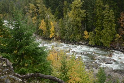
Experience natural beauty of river canyon scenery and wildflowers, birds and other wildlife, pictograph sites, and captivating cultural spirit and power of Stein River canyon. Enjoy extensive semi-open forests, old-growth trees (ponderosa, D-fir and redcedar) and lush side creek valleys. Naturalists and others will enjoy the diversity of birds and small to larger wildlife sightings, geology, and botanical interest including semi-open forests, many lichens and spring wildflowers. Plenty of photo opportunities of scenic river canyon landscapes, macros and abstracts as well as naturalist subjects and spring flowers, centuries old' pictographs and other cultural sites.
You can usually count on a dry or mostly dry backpack here, as the lower and middle valleys are situated in the rain shadow (rarely rains, except in winter).
Pace leisurely to moderate, paced with stops for photo opportunities and for enjoyment of nature. If you're seeking a faster pace or prefer a different objective than photography/nature enjoyment, this is not the trip for you. Thank you.
Approx drive time from Seattle: 4.5 hours, via Sumas WA crossing and TransCanada Hwy 1 to Lytton.
Optional: Car Camp evening prior to backpack at Canyon Alpine RV Park www.canyonalpinepark.com (tent sites & motel rooms, just N of Boston Bar, abt 25 min S of Lytton.
Stein Valley Nlaka'pamux Heritage Park is a unique large provincial park (similar in size to Rainier), without requirements for backcountry camp reservations, fees, permits. The park was recently nominated for review as a World Heritage Site! https://whc.unesco.org/en/tentativelists/6341/
See park website for more info, park brochure: https://bcparks.ca/stein-valley-nlakapamux-heritage-park/
A suspension bridge (currently closed) crosses the Stein River at about 7 miles, allowing access again to the Middle Stein valley and extended backpacking into remote sub-alpine/alpine upper Stein from the eastern trailhead. A very challenging 7-10 day world class traverse over the Stein Divide along high lakes, rugged terrain and snowfields is accessible during a short window about mid/late summer.
On day 1, we'll backpack approx 5 miles along/above the Stein River, between trailhead and basecamp in a Lower Stein Canyon camp (Teepee or Earl's Cabin). All designated camps have bearproof food storage (steel cabinets), pit toilets and nearby water source. On day 2. we'll do a day hike from our basecamp, along more pictograph sites and the scenic Lower Stein and Klein cabin area, and cross suspension bridge (if open and nearby slide cleared) into the Middle Stein valley as far as Riverside or Ponderosa camp. Day 2 mileage will range from 4 to 12 miles (dep. on bridge/slide status). On day 3, we'll return to trailhead, arriving mid-day to mid-afternoon.
Link to Club Tread Lower Stein Valley trail description, details enroute, and GPS waypoints for first 29K trail section: http://www.clubtread.com/Routes/Route.aspxRoute480.html?Route=480
Leader will have copies of trail description and topo map for participants, and pictograph interpretive info.
Recommended guidebook: Stein Valley Wilderness Guidebook (White), 2nd ed.
Background on Stein pictographs:
http://talonbooks.com/books/they-write-their-dreams-on-the-rock-forever (Leader will bring excerpts for those interested in pictograph interpretations)
Cultural/historical/natural history significance of Stein Valley Nlaka'pamux Heritage Park: https://www.spacesfornature.org/greatspaces/stein.html
Stein Valley bird species list: https://avibase.bsc-eoc.org/checklist.jsp?region=CAbctn29
NOTE: A free 2-vehicle cable ferry (Lytton ferry) crosses the Fraser river near Lytton, enroute to the trailhead. If seasonal high water temporarily closes the ferry or closer is imminent for a few days, the backpack will be postponed to first half of June. Leader will monitor ferry status and river levels in advance of the backpack.
If suspension bridge is closed during late spring trip, a longer trip into middle Stein will be scheduled in September or October for early fall colors.
Stein River Canyon & Stein Valley
-
CNTS Stein River 92I/5
Stein Valley: Heritage Guide and Map East - See full route/place details.
Required Equipment
The Ten Essentials plus overnight gear which may include:
- Tent with footprint/ground tarp
- Stove and fuel
- Sleeping bag
- Sleeping pad
- Water filter
- Bear canister or extra stuff sack and cord designated for hanging food
- Cooking pot/pan with plate and utensils
- Toilet paper and shovel or blue bag to deal with waste
- Trekking poles recommended for steeper train grades, crossing a few boulder fields, and possible short stream crossings (spring and early summer).
