Trip
Backpack - Marmot Pass
Enjoy a high mountain pass in the Olympics and lull yourself to sleep near the headwaters of the Big Quilcene River. Preference to Tacoma Branch Introduction to Backpacking Students. Trip will open to all Mountaineers on May 1.
- Sat, Jul 1, 2023 — Sun, Jul 2, 2023
- Tacoma Hiking & Backpacking Committee
- Backpacking
- Adults
- Moderate
- Moderate
- Mileage: 12.5 mi
- Elevation Gain: 3,700 ft
- Pace: 1.5 mph
- FULL, 2 on waitlist (4 capacity)
- FULL (2 capacity)
- Cancellation & Refund Policy
Quilcene Ranger Station 8am. Northwest Forest Pass required for drivers. Drive time from Tacoma to the ranger station is about 1.5 hours one way. From Seattle it will be longer. Participants should review the sailing times before signing up if they plan to travel via ferry to ensure that they can make the meeting time. Alternatively, participants may opt to stay some place local the night before the trip to reduce the drive time.
Preference to Tacoma Branch Introduction to Backpacking Students. Trip will open to all Mountaineers on May 1.
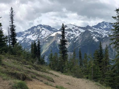
Come with us to see some snowy mountain peaks from Marmot Pass! This is a wonderful (but busy) early season trip on the east side of the Olympic Mountains where the rain shadow rules and where snow melts out earlier than in the Cascades.
We anticipate camping at Shelter Rock about half-way to the pass and about 2.5 miles and 1400 feet gain from the trailhead. Once we have camp pitched, there will be an optional day hike with our lighter packs to Marmot Pass with some exploration around Camp Mystery and the pass area. We'll take this part of the trip slow so we can all enjoy the surroundings as we approach the pass. When we have had our fill of mountain views we will return to camp to relax and have a group dinner beside the Quilcene River. Round trip distance and gain for the optional day hike is 6 miles and 2100 feet gain. Total trip distance and gain is 11 miles and 3500 feet gain
Travel and hiking considerations:
- The forest service road to the Big Quilcene Trailhead can be rough and filled with potholes. Expect to drive in these conditions for about 45 minutes to an hour. The distance is only 12 miles from the ranger station to the trailhead but the driving is very slow so pack your patience. 4WD or AWD vehicles recommended.
- Microspikes (that fit your boots/shoes) may be required if there is still lingering snow or ice on the trail. Borrow or purchase these if you don't have them already.
- Be mindful of the altitude we will begin (2400 ft) and end at (5900 ft) and consider your fitness for hiking at higher altitudes in early season.
My style: I prefer a more social experience and enjoy the company of others on trips. When I’m not socializing you will probably catch me gazing at the beauty of the backcountry or taking pictures of it. I’ve been known to swim in alpine lakes, stand underneath waterfalls, and soak my feet in cold water after a hard day hiking. In the evenings I like to sit around the campfire or communal area and drink my tea to wind down for the night and I’m usually up early in the mornings sometimes to watch the sunrise with a warm drink. If these sound like experiences you would enjoy, I’d love your company!
Marmot Pass & Buckhorn Mountain
-
Custom Correct Buckhorn Wilderness
Green Trails Tyler Peak No. 136
Green Trails Olympic Mountains East No. 168S
Trails Illustrated Olympic National Park - See full route/place details.
Required Equipment
To be discussed at lecture for Introduction to Backpacking course students.
The Ten Essentials plus overnight gear which may include:
- Tent with footprint/ground tarp
- Stove and fuel
- Sleeping bag
- Sleeping pad
- Water filter
- Bear canister or Ursack
- Cooking pot/pan with plate and utensils
- Toilet paper and shovel or blue bag to deal with waste
Microspikes may also be required.
