Backpack - Devils Dome/Jackita Ridge

Trip

Backpack - Devils Dome/Jackita Ridge

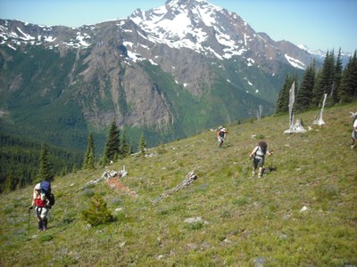
This very strenuous counter-clockwise, view-rich circumnavigation of Jack Mountain (The King of the Skagit), 43 miles and 7300 feet of gain, is one of the best loop backpacks in the state, for those who are ready for the devilish effort required! Please submit details (distance, gain/loss, pace) of your recent backpacking trips when you request permission. NOTE: Each participant will need to contribute $35 toward our boat shuttle back down to Ross Dam at the end of the hike. PERMISSION REQUESTS WILL NOT BE ACCEPTED UNTIL REGISTRATION OPENS.

  • Very Strenuous
  • Challenging
  • Mileage: 45.0 mi
  • Elevation Gain: 7,300 ft
  • High Point Elevation: 6,365 ft
  • Pace: 1.5-2 mph

We’ll arrange pickups at participants’ homes at around 6AM on Aug 10, 2023, drive to Marblemount and gather there to collect our backcountry permits (8:00), and then on to drop off a vehicle at the Ross Dam trailhead before heading on to the Canyon Creek trailhead (22 miles past Marblemount, 2.5 hours from Bothell) where we’ll start. Carpools will be encouraged – details will be coordinated the week prior to departure. A NW Forest Pass will be required for each vehicle.

Circumnavigate Jack Mountain, the King of the Skagit, on this extraordinary loop along high ridges with endless North Cascades views and green meadows!

On day 1 we will climb 3400 feet in 4 miles from the trailhead to the Crater Mountain trail junction and drop packs for the amazing side trip to Crater lake on the flanks of Jack Mountain. Then we’ll return to the junction and continue 3 more miles to camp at Devil’s Park shelter, 5800’ (day 1 total 6 miles and 3800’ plus side trip). On day 2, we’ll climb to Jackita Ridge at 6200’ and drop packs to walk up to the ridge to panoramas across Jack Mtn and the North Cascades, before transiting the endless ups and downs and multiple steep scree- or snow-fields to Devils Pass (5800’); from there we’ll turn west and climb 400’ across a lush basin to Skyline Camp (6300’), 11 miles and ~3000’ gain on day 2 (this could be a dry camp, with water-carry 3 miles from Devil’s Pass). On day 3 we’ll climb 500’ in 2 miles across flower and berry fields to reach the trail’s high point at the now demolished Devils Dome lookout, 6980’. From there, a descent into a basin of waterfalls and flower fields takes us around Devils Dome before descending steeply for 9 forested miles and 5240’ to the shore of Ross Lake where we'll camp at Devil's Point, for a day 3 total of ~11 miles and approx. 1000’ gain. A boat from the Ross Lake Resort will come to pick us up  on the morning of day 4 (details and cost TBD) and take us to the Ross Dam trail where we'll have a short hike uphill to the road and parking area. A monetary contribution will be requested from each person to cover the cost of the boat shuttle.

Early August weather is generally good, 70s or higher during the day and 40s to 50s at night, but participants must be prepared for possible rain and temps that could dip to freezing. This will include a good rain- and wind-proof shelter, non-cotton layered clothing and raingear plus a sleeping bag that will keep you comfy down to 35 degrees; as well as your 10 essentials of course! Please test your stove, headlamp, water filter, rainproof shelter and gear to be sure they’re working before the trip! The leader will encourage and coordinate sharing of gear in advance.

The route is rated Very Strenuous, though our days will not be extremely long, 8-12 miles. We will maintain a moderate pace (1.5-2 mph on the climbs, 2-2.5 on the flat). The high point of the trail is 6980’. We’ll set up camp at 3 or 4 PM each day (depending on side trips) and get up with the sun so that we can get on the trail by 7:30 or 8AM. We’ll take a short (30 minute) lunch break, timed with the best viewpoints.  

This route is grueling in parts, so participants must demonstrate a high level of conditioning and ability to travel at the posted pace with only occasional rest stops, based on recent backpack trip experience. In addition, the experience to pack light while carrying sufficient gear, water and food will be a requirement (assistance in gear and food planning will be provided in advance.) The route is easy to follow but does involve descents across steep scree with occasional snow patches, so participants must have good balance and confidence on loose rock and we’ll require microspikes and at least one pole if snow is present on these sections (the trip will cancel or we’ll turn around if ice axe skills would be required).

The trip may be cancelled or moved without much advance notice if weather or snow conditions are poor.

Route/Place

Devils Dome/Jackita Ridge


Roster
Required Equipment

Required Equipment

The Ten Essentials plus overnight gear which may include:

  • Tent with footprint/ground tarp
  • Stove and fuel
  • Sleeping bag
  • Sleeping pad
  • Water filter
  • Bear canister or extra stuff sack and cord designated for hanging food
  • Cooking pot/pan with plate and utensils
  • Toilet paper and shovel or blue bag to deal with waste
Trip Reports