
Ingalls Peak/South Ridge
A fun, three-pitch rock climb on good rock with a few 5.2-5.3 moves and some exposure. Enjoy the approach through an Alpine Larch forest and views of Mount Stuart. Expect snow in June and early July, and hot temperatures by August. Times: 3-4 hr approach, 3-5 hr climb to summit. This is a great first alpine rock climb. It's also very popular—consider one of the alternate basic rock climbs, the Ingalls Peak/Southwest Face or Ingalls Peak/East Peak/Southwest Face.
Getting There
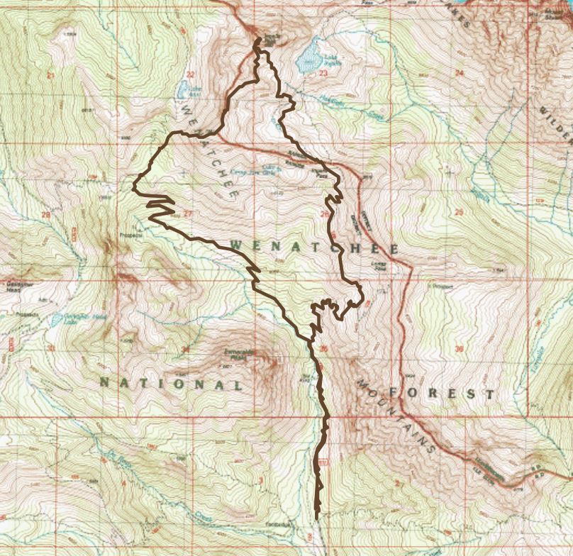
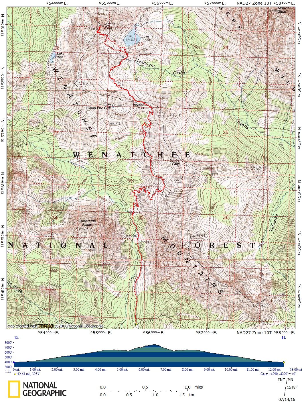
Drive I-90 to about 1 mile east of Cle Elum, then drive northeast on SR-970 5 miles to 0.5 mile past the Teanaway River Bridge. Turn left on the Teanaway River Road and continue 23 miles to the road end parking area at 4,243 ft, about 1 mile beyond the DeRoux Campground. Car camping is available at the DeRoux Campground and other campgrounds on the Teanaway River Road.
APPROACH
Hike the abandoned mine road/trail 0.25 mile to fork in trail, and turn right onto the Ingalls Way Tail. Stay left at the fork at 5,600 ft and hike 3 miles to Ingalls Pass (6,500 ft). From the pass continue on trail to Ingalls Lake (6,400 ft), 4 miles from trailhead.
South Ridge | Southwest Face | East Peak/Southwest Face
Ingalls Peak/South Ridge (7,662 ft)
ASCENT ROUTE
Scramble from the lake to the notch between the main (north) and south peaks. From just below this notch, traverse along the right side of the Dogtooth Crags, climbing broken rock and slabs to a broad bench just below the large red slab. Alternative: Follow a slab-ramp along the left side of the Dogtooth Crags, go around a corner, and climb a knife-edge ridge.
Climb the obvious crack for a full rope length lead to a belay at a fixed piton on the slab. A short pitch and left leads to a belay cove under the dark horns. Another short pitch goes up and right from the right side of the cove to a notch in the left skyline. From there, scramble to the summit.
DESCENT ROUTE
Rappel the climbing route or the Southwest Face route.
TRIP PROFILE
| SEGMENT | TIME (HR) | ELEVATION GAIN (FT) |
|---|---|---|
| Trailhead to Notch | 3-4 | 3,000 |
| Notch to Summit | 3-5 | 400 |
| Summit to Trailhead | 4-5 |
EQUIPMENT
Standard rock gear with chocks to 1.5 inches.
NOTES
- The hike in may be hot, but is not especially strenuous.
- Climbing is on generally good rock with moderate exposure.
- Rope leaders should have Class 5 leading experience, as the red slab requires protection and has several tricky moves in the 5.2-5.3 range with a 5.6 variation, if desired.
- This climb is typically done as a one-day climb with a 6-7am start.
Ingalls Peak/Southwest Face (7,662 ft)
ASCENT ROUTE
Ascend to the notch between the main (north) and south peaks. From the notch at the base of the south ridge descend west about 100 feet to the base of a friction slab where the climb begins. Ascend the friction slab to a belay spot where there are old pitons. From the belay move left and then up a class 3 gully for one fairly long pitch to a tree. Scramble right, then climb a gully to the belay cove under the dark horns on the south ridge. Another short pitch (now on the South Ridge route) goes up and right to a notch in the left skyline. From there scramble to the summit.
DESCENT ROUTE
Scramble northwest down a ridge to a minor saddle that is somewhat exposed with some loose gravel. Descend and traverse to a tree at the top of a Class 3 gully that was climbed used on the ascent. Rappel down the gully and then down a friction slab to the base of the ascent route. Scramble back up to the notch and return to the trailhead from there.
TRIP PROFILE
EQUIPMENT
Standard rock equipment.
NOTES
- The hike in may be hot, but is not especially strenuous.
- The climb is generally on good rock with moderate exposure.
- The climb is easier than the South Ridge route with only a couple of low fifth class moves.
Ingalls Peak/East Peak/Southwest Face (7,480 ft)
ASCENT ROUTE
Scramble to the notch between the main (north) and east peaks. Climb to the good belay ledge just above the chockstone in the notch. Climb slabs and then a gully to a large ledge, generally trending to the right. Then follow the ridge to the summit, watching for lose rock.
DESCENT ROUTE
Rappel the climbing route.
TRIP PROFILE
EQUIPMENT
Standard rock equipment and chocks to 1.5 inches.
notes
- The hike in may be hot, but is not especially strenuous.
- Watch for loose rock on the final ridge.
Information for LEADERS
Priority Climbs List
This is a very popular climbing route. Please check the PRIORITY CLIMBS LIST before listing trip to be sure your branch has priority for this route for the dates you plan to schedule it.
- Suitable Activities: Climbing
- Climbing Category: Basic Alpine
- Seasons: June, July, August, September, October
- Weather: View weather forecast
- Difficulty: Basic Rock Climb, Strenuous 2, Technical 2, Basic Experience Climb
- Length: 8.0 mi
- Elevation Gain: 3,500 ft
- 7,662 ft
-
Land Manager:
Okanogan-Wenatchee National Forests
Alpine Lakes Wilderness, Cle Elum Ranger District (OWNF)
- Parking Permit Required: Northwest Forest Pass
- Recommended Party Size: 6
- Maximum Party Size: 12
- Maximum Route/Place Capacity: 12
- Green Trails Mt Stuart No. 209
- USGS Mount Stuart
This is a list of titles that represent the variations of trips you can take at this route/place. This includes side trips, extensions and peak combinations. Not seeing a title that fits your trip? Log in and send us updates, images, or resources.
- Ingalls Peak/Southwest Face
- Ingalls Peak/East Peak/Southwest Face