Trip Report
Snowfield Peak/Neve Glacier
Great climb in the North Cascades that provides a great overnight challenge.
- Fri, Jul 12, 2019 — Sat, Jul 13, 2019
- Snowfield Peak/Neve Glacier
- Climbing & Scrambling
- Successful
-

- Road suitable for all vehicles
-
Still plenty of snow and closed up crevasses. The forest scramble to lower camp was pretty obvious with the combination of paying attention, GPS and occasional flagging/cairns. See trip report for more details.
Pulling and modifying from Brian and Rikki's 2018 reports with updates here. We followed Brian Starlin's Gaia GPS Route with very little variation except when snow cover required us to change route on the descent onto the Neve Glacier and when gaining the base of Snowfield.
This beta was also shared on virtual Beta & Brews: Less Traveled Basic Routes.
-------
Trail to Pyramid Lake- steep and rooted, easy to follow. ~1 hr to Pyramid Lake from trail head.
Climber's trail to low camp- easy to follow if you have "a nose" for climber's trail. Very steep, little 'shwacky, downed trees/branches to cross, mossy boulders to scramble. Snow free. The SW trail that begins from Pyramid Lake is much more apparent and easier to follow than the SE trail that heads off from the lake. Both eventually meet up. There was flagging posted around to help with small re-routes around parts of the trail that have down trees.
All the duffy scramble action. Credit: Carl Malec
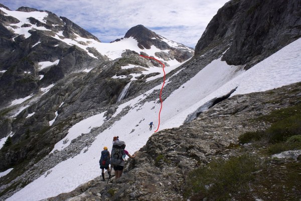
Route from low camp to high camp - In order to gain the line the traversed below Paul Bunyon's stump we proceeded from low camp and around the ridgeline to the SE or climbers right. We encountered some moderate snow slopes and route-finding before gaining a small saddle that descended a climbers trail to the route below PB's Stump.
There was more patchy snow along the traverse under PB's stump. Traverse above waterfall was mostly soft snow with a firmer boot pack trail beaten in already. A few bands of loose boulders/talus to cross. Be careful of rockfall from above late in the day, I would suggest moving quickly and not taking breaks along the traverse above the waterfall.
Panorama near low camp (Credit Carl Malec). Ohh ahh
High camp- We had a tarn to filter water from near the camp sites, snow free on the ridge. Nice dirt/rock camp spots with wind walls built up. ~4 next to the tarn big enough for tents but you could also find more bivy spots nearby. If those are all full when you go you can find 2 or so more by traveling farther down the ridge. Beware, we had some really heavy winds in this section and our group had trouble keeping our tents anchored and sheltered at first.
 Route to High Camp from the saddle. (Credit Skye Stoury)
Scramble up to the high campsite. (Credit Petra Damm)
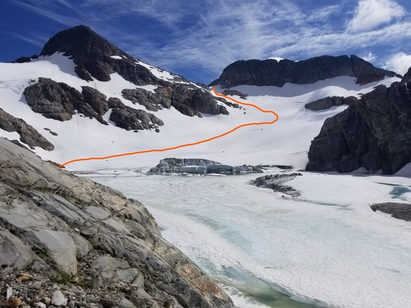
Colonial Glacier- the glacial lake is beginning to melt out. We followed the rocky ridge path SW to the southern end of the glacial lake to gain the snowfield. We placed a few tarns but it's highly recommended to scout the route the day before your morning alpine departure. Was easy to skirt around it up to the Colonial-Neve Col, only a few open crevasses off to the east and moderatly steep ascent. No pickets were used to get to the Col. Pay special attention to the approach to the Col, if you turn up too early your route will turn into a rock scramble, turn too late and you'll be directly below the cliff face. Look for the middle of the road route.
 Approach from high camp to Colonial-Neve Col Camp across Colonial Glacier . (Credit Petra Damm)
Colonial-Neve Col camp- had running water, 2 windwall melted out rock/dirt camp spots that I noticed (but one of them is smack dab in the middle of the col and would be annoying to sleep there while climbers trudged past early in the morning IMO).
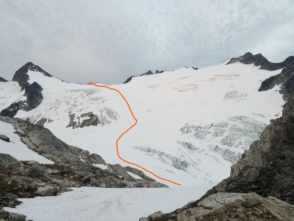
 Route along Neve Glacier to Snowfield as viewed from Colonial-Neve Col Camp (Credit Carl Malec)
Neve Glacier- After about 10 meters of walking on rock from the col we hit snow. The initial descent to the glacier was a little tricky. We decided to go far skiers right down a steep slope rather than trying for a small rocky notch on skiers left. The route took us down a steep snow slope that required pickets for protection. Some crevasses were opening up but it was easy to navigate through the Neve glacier to the base of Snowfield. We split the group into two teams of three with one team on a 30m glacier and the other on a 60m 9mm full strength rope. We brought the 60m to use on the scramble.
Looking up at descent from Colonial-Neve Col Camp onto the Neve Glacier. (Credit: Skye Stoury)
Summit ridge, gully, summit block- All snow-free. Ridge had a bootpack trail leading to the gully, gully had a cairn on the left where you pop out over the arete. There are a lot of climbers and desire trails on the way to the gully. View from the base of Snowfield SPOILER ALERT!(Credit Carl Malec)
Walk up Snow Field scramble portion from Neve glacier. (Credit: Carl Malec)
As mentioned in Brian's description there are a few ways to get to the summit block. I'll outline the two we used on the ascent/descent.
1. Climb up the gully on climbers left and look for a small traverse/scramble out to the left (SW direction on the northern aspect of the mountain. You should see a few cairns and come to the base of a 4th class scramble along the NW face. We had the leader set a 60m handline from the starting point past an obvious notch with a large arête block to the climbers left. You'll see a large belay station with a cairn, just beyond this is the "airy traverse" move across a block with a gully to the climbers right. Recommend you anchor the rope just past the "airy traverse" move and have the last follower clear gear on the way to the summit. From there it's a short scramble on the climber's right to the summit.
The leader had a single set of cams .3"-2" without nuts, a few single runners, 1 double, few lockers and a cordlette. We were going to belay with a munter but a student just happened to bring an ATC. This was as more than enough for the scramble of the summit block. Placed a .75 on the scramble and just needed the pro for building the handline anchor at the end.
Photographer is looking down at the end of the hand-line scramble. Behind them is the final scramble to the summit. Climbers in image are at the top of the first portion of the scramble before the crux "airy-traverse" along the handline. There was space for 6 people to stand comfortably where they are at. Note to the far left of the image is the base of the gully discussed below in #2 and the notch you can climb back up. (Credit: Skye Stoury)
2. From the summit, we descended directly down a 4th class gully on the SE face of the peak directly below the summit. We set a hand line that extended from the summit to the base of the scramble in a gully. Students greatly appreciated it. At the base of the scramble is a short jaunt up another gully (10m) to the notch of the gully that was followed to the base of the scramble mentioned above. A hand line was set in the 10m notch portion but only one person used it, the rest free climbed it.
Looking down from the summit. Scramble down the deep gully to the notch. (Credit: Brian Starlin's 2018 Trip Report.)
Climbing Timeline
Friday, July 12
Climb Leaders arrived at Marblemount for permit | 7:01 AM (It was crowded! 13th in line)
Met at Pyramid Lake Trail Head | 8:30 AM
Depart Trail Head | 9:00 AM
Reached Upper Camp | ~3:30 PM
Saturday, July 13
Depart for Summit | 3:30 AM
Summit | ~10:30 AM
Summit Rest | ~15 minutes
Returned to Upper Camp | 2:00 PM
Rest & Pack Up Camp | ~1 hr
Reached Cars | ~7:30pm
 Garrett Arnold