Trip Report
Sea Kayak - Goat Island
Goat Island, Fort Whitman visit.
- Fri, Nov 10, 2023
- Sea Kayak - Goat Island
- Goat Island
- Sea Kayaking
- Successful
-

- Road suitable for all vehicles
-
NOAA issued Gale force winds and small craft advisory in the morning. La Conner tides: low at 9:10 am and 4.4 ft; high at 2:53 pm and 9.95 ft. Skagit Bay, 1 nm south of Goat Island current: Ebb at 9:01 am, 1.6 knots, 147 degrees; slack at 12:23 pm; flood at 2:41 pm, 1.74 knots, 147 degrees.
The boat launch is the typical concrete ramp. South of here, estimating around 1000 ft, by the children’s play area, is a muddy beach. Don’t recommend launching here at low tide because it’s slippery. If anticipating returning at high tide probably a good idea to drop kayaks off near the concrete boat ramp and park close to the children’s park. One porta potty close by here.
Local articles re predicting Swinomish Channel flow say that south flow occurs 2.5 hours to 4 hours before and after low tide, and north flow occurs 2.5 to 4 hours before and after high tide. Today predicting that time is tricky since the time between low and high tides is less than 6 hours. Plus, a 2.5 to 4 hours is a pretty big spread. Quite possible to miss that prediction completely. I believe that noting when slack is at the Skagit Bay, 1 nm south of Goat Island, current station is a good predictor of about when the flow will start to reverse. I think that worked well for us today.
Since the forecast winds were pretty high we decided to paddle anyway and see what the area between Goat Island and south channel looked like.
Parked at the Town of La Conner Public Boat launch around 9:30 am with a planned launch by 10:30 am. I was planning to swing by the Hole in the Wall and check its status. The tide would still have been quite low, but rising, when we’d get there. I wasn’t sure if we could make it through but if we could we probably would and thus approach Goat Island in a clockwise direction. We launched around 10:15 am. When we got to the channel the wind wasn’t too bad yet. Unfortunately, Hole in the Wall was plugged by a couple of rather large trees, not just logs. At this time I’m estimating the tide to be about 6 ft at about 10:50 am. For sure we could not go through it then but may be possible when the tide is higher.
We paddled to Goat Island directly. Pretty easy paddle with the flow going our way even with the quartering tail wind. We landed at the beach where the trail to Fort Whitman is at (about the northern, and north western “point” near where the pilings start. Landed about 11:15 am
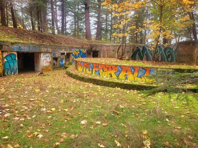
We walked up to Fort Whitman, toured the site, and had lunch. (Worth noting here that the first part of the trail from the beach is getting eroded.) The wind audibly grew louder during our stay. Sensing that the wind was getting worse we decided to paddle back to La Conner and skip going around Goat Island and going through Hole in the Wall since we weren’t sure if we could get past the tree blockage. We launched around 12:15 pm, which is close to the slack time (12:23 pm) at the channel. This is why I think that noting when slack is at channel (Skagit Bay, 1 nm s of Goat Island station) is a good idea in predicting channel flows. Despite the strong headwind, estimating around 15 knots, according to GPS we still maintained around 2 knots. It was hard work but I’ve been here in similar winds but with opposing flow we managed only 1 knot. Tide was also high enough for us to paddle close to the break water which provided relief from the wind.
Easy paddling once we got to the south entrance of the Swinomish Channel. Now with northerly flow and when exposed to some tailwinds GPS indicated that we sometimes drifted at 1.5 knots. We decided to enter Shelter Bay for some exploring, more like day dreaming. Some of the houses were really nice. Landed at La Conner boat launch around 1:30 pm.
 Rene Buendia