Trip Report
Mount Baring/Northwest Ridge
Lots of soft snow made for slow and difficult travel. Colder weather or waiting until the ridge melts out will improve success rate!
- Sat, Mar 26, 2022
- Mount Baring/Northwest Ridge
- Scrambling
- Turned Around
-

- Road suitable for all vehicles
-
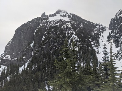
Currently, the snow starts right below the ridge and slowly gets deeper as you traverse the ridge until there's a good few feet. With the warm weather it was extremely soft, making travel difficult since you sink in to mid calf with each step. There are some harder/icy spots once you start side-hilling along the ridge, so I'd put on crampons there. There were some chonky cornices overhanging where the trail would run through the basin, but they'll be difficult to see from the basin itself. The gully to the saddle was covered in fresh loose wet avalanche debris. North summit and traverse up the ridge from the saddle looked fairly clear of snow, but it was hard to tell with how far away I still was. With a cold snap to firm up the snow this would be doable, but otherwise it may be wise to wait until the ridge has melted out and there's just enough snow to cover the gully to the saddle. The trail takes a stupidly long time so this isn't one to be racing a warming snow pack on unless you want to do a real alpine start.
Some route finding information: trail leaves from the Barclay lot up the old forest service road 6024 behind the bathroom, not down the main lake trail. Can be confusing in the dark. Trail leaves the road right before the stream, basically go up the stream bank on the right side and you should be able to pick up the trail there. The first flag is hard to see from the road. From there the trail is relatively easy to follow, it splits and rejoins a few times but I always stuck left and kept finding more trail markers. Once you gain the ridge the trail markers are few and far between and the trail was totally lost in the snow. You can fudge it following Gaia and just stick to the correct side of the ridge when the trail dips below it. The only really important spot is the turn at 47.77871, -121.44662 to cut under the top of the ridge and then traverse to the basin under the gully.
The trail is extremely challenging. I thought the ridge would be a nice walk and even that was hard! It took 1:40 to get up the half mile road walk and up the ridge, then another 1:50 to get to where I stopped above the basin. I'm in pretty good shape and that was all I had in me for the way up, considering the way down from the ridge is just as stressful/difficult.
 Tim Wick