
Trip Report
Glacier Climb - Snowfield Peak/Neve Glacier
With Photos. Good summary of Snowfield Climb, route, logistics, etc.
- Sat, Jun 23, 2018 — Sun, Jun 24, 2018
- Basic Glacier Climb - Snowfield Peak/Neve Glacier
- Snowfield Peak/Neve Glacier
- Climbing
- Successful
-

- Road suitable for all vehicles
-
Late June. Patchy snow between 4,500' and 5,200', then steady snow after that. Wore crampons on the traverse of snow below Pyramid Peak. The new lake at the toe of the Colonial Glacier had open spots, but was not melted out. There were tarns in varioius places from recent snowmelt, at 4,500', at 5,400', and at the camps at 5,900'.
During the climb, we crossed the Colonial Glacier with crampons, but without rope. We roped up at the col to the west of Neve Peak, and remained roped across the Neve Glacier. There were small crevasse cracks, but nothing serious, huge, or nothing that required any navigating around them.
The Snowfield ridgeline was snow free. The gullies were snow free. There was a small patch of snow on the ledges about 8,200', but easy to get around and not causing any issues on the scramble. The final gully and the summit were snow free.
There were mosquitoes on the Pyramid Lake Trail, but we left them behind at about 3,200'.
The trail into Pyramid Lake was very nice. It's a trail.
The section from Pyramid Lake onto "Big'um Ridge" is steep, but not bad. On the ridge, I remember two very steep sections. One was from about 4,000' to 4,500'. The second was from about 4,700' to 5,200'. Those were very steep with big steps and several "bush belays". The whole ridge is a slow-go no matter what.
The campsites at 5,200' were snow covered. Those on the rocky ridge at 5,900', above the toe of the Colonial Glacier were melted out and excellent! Highly recommended.
Two day trip. This may be better as a 3-day if you can spare the extra day.
- Met at Trailhead 7:30 AM on Saturday. Car to Camp at 5,900' - 8 hours
- Left camp 4 AM on Sunday. Summited at 9:40 and relaxed an hour. Back to camp at 2 PM. (total camp to camp ~10 hours).
- Left camp at 3 PM, reached cars at 9:30 PM (slowed down by a sprained ankle)
I think this is a good time of year to do this climb (Late June). Earlier in June of most years, there will still be snow near the summit block, and it will be crappy, unprotectable chunks covering slippery slabby ledges on the north side. Much later, and the traverse below Pyramid Peak will be a bunch of scree I think. This was just about right as far as conditions went.
This was a pretty standard group in decent shape. I told them to be well rested for several days before the climb. They needed it. We hit the trail at 7:45 a.m. Everyone had about 2 liters of water to get past the lake and up the "Big'um Ridge".
The weather was pleasant, neither too hot nor too cold. There were plenty of clouds drifting through on Saturday. They thinned as the day progressed, with the expectation that it would be clear during the day on Sunday, and increasing thunder clouds on Sunday night. That is exactly what we got, and it was perfect because we had cool weather on approach, and clear skies during the climb when the views are awesome! Do this on a good day. Don't do it on a crappy day. Why?
The Pyramid Lake trail is in great shape, covering about 2.5 miles directly into the small lake. There are apparently two routes from the lake to the ridge. We went around the right side of the lake to a rocky overlook, and took an obvious boot path southwest for a hundred yards, and then it turned southeast to the ridge. There is supposed to be another path that goes further around the lake to the SW side, and then up to the ridge. Both of them work their way up to "Big'um Ridge", which is the ridgeline that heads westerly toward Pyramid Peak. I call it "Big'Um Ridge" now because it's big and long, and we spent most of two days on it, up and down.
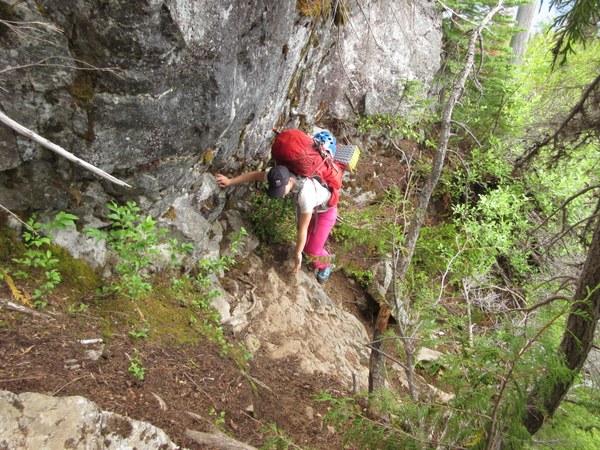
At about 11 AM, we reached a nice little bench on Big'um Ridge and had lunch. It's at about 4,500' and can be recognized by a metal post sticking out of the rocks marking the boundary between Ross Lake NRA and the Nat'l Park. There were a couple small tarns of recent snowmelt but nobody needed any water yet.
Right after lunch, I lost the trail under snow at around 4600'. The USGS map shows point "4614" there. I started to go straight over that knob of rock, but then realized that the trail goes around the right (north) side of that, and then stays on the north side of the ridge until about 5,000'. We had patchy snow from 4500 to 5200 feet, and then solid snow from 5,200' onward. At about 5,200', we went leftward, up onto the open ridgeline, where the views of the peaks, waterfalls, and the basins shocked our senses. The views were to the Pickets and beyond in the north, the North Cascades to the east, and views up into the Colonial/Neve/Pyramid basin to the south. Simply amazing. There are camping spots at around 5,200 to 5,400', but they were all covered in snow. There were small pools of snowmelt and we had run low, so we quickly filtered a few liters.
This shows the view of the Colonial Creek (waterfall), coming out of the small gap that goes into the Colonial Glacier basin. Colonial Peak is on the left, Neve Peak in the middle, and Pyramid Peak on the right. The traverse below Pyramid is the snow field across the lower right, and above the waterfall.
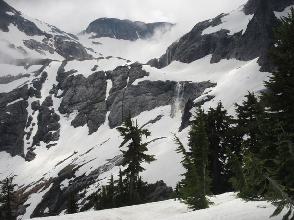
Our goal was some camps at 5,900', so we had to traverse the slope below Pyramid Peak, heading southerly into the basin that hides the toe of the Colonial Glacier. To get there, I guess you have a choice of two routes. There is a 5,640 foot knob of rock (and snow) at the top of the ridgeline, just before the really steep eastern side of Pyramid Peak.
My two GPS tracks from other people went different ways around this knob. One of them stayed east-southeast of this knob and dropped several hundred feet into the Colonial Creek drainage, traversed southward, and then climbed back up to the 5,800 foot level before entering the toe of Colonial Glacier. The other stayed north of this knob until reaching a little saddle between the knob and Pyramid Peak. Then it traversed southward along the 5,800' contour line to the toe of Colonial Glacier. We chose the latter and stayed on the 5,800' contour. It was all on snow and made for a very good traverse. We wore crampons to secure our footing because the snow was steep, icy in spots, and required careful concentration to avoid slipping.
This shows Colonial Peak on the left, Neve on the right. We're on the traverse below Pyramid Peak, heading to the rocky ridge just right of center where there are some campsites at 5,900'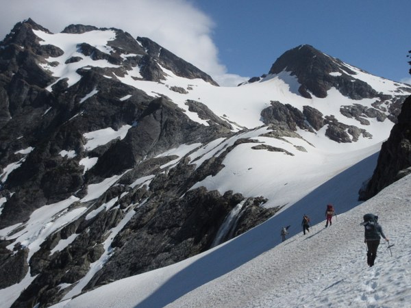
The toe of the Colonial Glacier is in a large bowl, hidden behind a ridge that comes down the northwest side of Colonial Peak. That same ridgeline contains several great campsites. At this time of year, the lake was frozen and seemed to have large chunks of ice within it. There was a tarn of recent snowmelt on that ridge as well, so we didn't have to go down to the "lake" to get water. Reached camp at 3:45 pm. 8 hours from trailhead. (Photo shows camp with small tarn. The glacial lake is down to the left.)
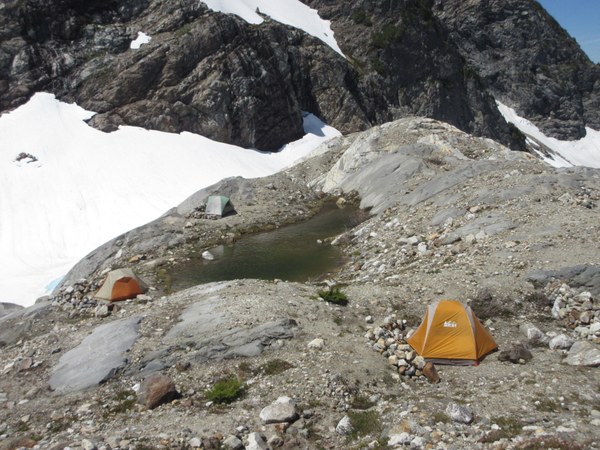
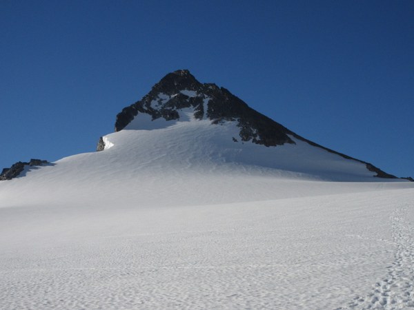
In the morning, left camp at 4 am. The first part of the route was obvious. Went around the southeast side of the lake, and headed SSW toward the col to the west of Neve Peak. Dropped down from the col about 400' onto the Snowfield Glacier and worked up the glacier to the ridgeline that is visible on the right side of Snowfield Peak. There were only a few small cracks and a few larger crevasses to hop over. The largest was maybe 6-12" open at the top, but not yet open down below. Very benign glacier this time of year.
We went up a snowfield just this side of the ridge, to catch the ridge at almost 7,800'. That section of snow is just below the ridge on the right side of the peak. It probably didn't save us any time by going up the snow vs the ridge. The trail on the ridge is easy to follow until it begins branching about 8,000'.
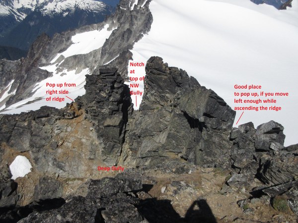
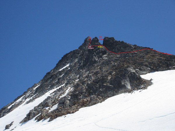
The Mountaineers Description is pretty good. I'll add italics for clarity -- "Around 8,100~8,200 ft, traverse left about 100 ft into obvious, northwest facing gully with an obvious notch at the top. Scramble up gully about 50-100 ft (about half way). Traverse left, onto arête and over the the arete onto a series of scramble ledges. Go up about 75 ft (to where it steepens below pinnacle). Traverse left along rock ledges, then up on north side about 150 ft to notch between pinnacle and summit. Cross this notch to the summit block. There is a deep gully to the right side of this notch. Once at the base of this summit block, go up ridge 20 ft, then traverse right on a ledge to a gully on south side of summit. Follow easy gully about 150 ft to summit."
Basically, we saw three ways to get up to the base of the summit block. If you lean to the right as you climb the ridge, you pop out above a steep west-facing gully. If you get into the NW-facing gully and go all the way to the top where you see a notch, you will look over the same steep west-facing gully. If, however, you only go halfway up that particular NW gully, and then traverse leftward over the arete and go up 150 to 200', you will be at a notch that carries you over that steep gully and onto the base of the summit block. The picture below shows the obvious view from the summit, and the three points you might pop out to.
A view from below, showing the NW Gully, the Arete, and the set of ledges to the left.
We summited at 9:40 am, for a time of 5 hours and 40 minutes from camp, relaxed for about an hour, and got back to camp about 2 pm. We were packed up and back on trail at 3 pm, expecting to reach the cars by 8 pm. We carefully worked our way down the "Big'um Ridge", but one team member sprained her ankle just before Pyramid Lake at 7:30, which slowed us down considerably to about one mile an hour. She tightened the top of her boot and borrowed hiking poles for the last 2.5 miles, and we reached the cars at 9:30 pm (the ankle was much better after a few days of rest).
As Christine said on Monday, "Ruthless is how I would describe this climb. It offers everything. Steep rooted climbing trail, steep traversing on snow, glacier travel and then class 3/4 scrambling to the summit. It goes on for miles and miles. Snowfield is massive and this is one of the most beautiful climbs I’ve ever been on next to McMillan Spire. As always, I’m thankful for the opportunity. And can barely walk today."
 Brian Starlin