Trip Report
Backpack - Windy Lake
The route had much more snow than expected and we did not go as far as we had planned, but the trip was still a success.
- Fri, Oct 13, 2017 — Sun, Oct 15, 2017
- Backpack - Kaleetan Lake
- Pratt Lake Trail
- Photography & Backpacking
- Successful
-

- Road suitable for all vehicles
-
Trails were well-maintained. Water was available at multiple stream-crossings along the route, as well as on the shores of Pratt and Lower Tuscohatchie Lakes. There were at least three campsites for small teams (3-4 tents) along Pratt Lake, just south of the Melakwa/Lower Tuscohatchie Trail split-off.
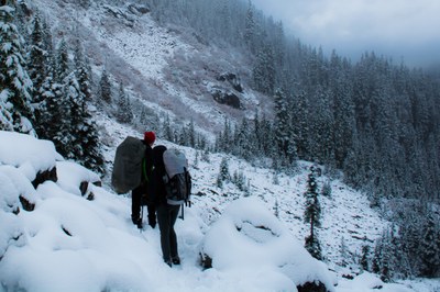
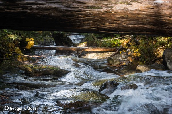
Most of the route had some snow; there were several inches around the saddle above Olallie Lake (see image 1). Some snow melted on day 2 and froze that night, resulting in a combination of hard snow and ice covering much of the route back to the Pratt Lake Trailhead on day 3. Stream crossings required caution due to icy and submerged rocks. Crossing Pratt River required extreme caution (see image 2).

As of mid-October 2017, the route from Pratt Lake Trailhead to the Pratt River via Lower Tuscohatchie Lake is best suited to teams of backpackers who are prepared to hike and camp on snow, cross high-running waterways, and use snowshoes and micro-spikes. If snowfall continues at a rate similar to what it has been so far this fall, the route will likely require (vs. recommend) snowshoes and micro-spikes. Generally a great route, but requires special planning and gear in late- and early-season.
The trip from Pratt Lake Trailhead to Pratt River (where we turned around) and back was 16 miles long with 4,000 ft of elevation gain and a 4,170 ft high-point.
Day 1: We reached the trailhead shortly after 0900 and inserted at 0925 after double-checking our gear, reviewing the route, and self-issuing the National Forest Service Backcountry Permit (available several yards up the trail, not visible from the parking lot). Started seeing snow on the trail and seeing snow fall within the first two miles, increasing to several inches at the saddle above Olallie Lake (see image 1). Snowshoes would have been very helpful but not necessarily worth the weight. Some snow was expected, but not nearly this much.
We reached Pratt Lake around 1330 and decided to set up camp there rather than continuing on to Lower Tuscohatchie Lake. There were at least three suitable campsites; we opted for the one site that was not covered in snow.
Day 2: We decided to leave our tents at Pratt Lake and return at night, rather than carry our overnight gear to Windy Lake and back to camp at Lower Tuscohatchie Lake. Found a great view of Kaleetan Peak and the Pratt River valley along the trail between Pratt and Lower Tuscohatchie Lakes. Reached the Pratt River and found it running high; rocks to step on were visible but under or barely above water. Crossing was only possible by using a large log as a handrail. (See image 2, which I took from the center of Pratt River looking under the handrail.) We decided to turn around because not everyone on the team was prepared for a river crossing like this.
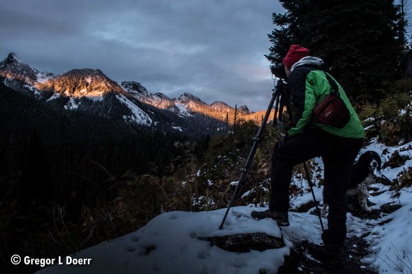
Returned to camp at Pratt Lake and relaxed. Left camp around 1730 and returned to the Kaleetan Peak viewpoint to take sunset photographs (see image 3). Returned to camp and got in sleeping bags.
Day 3: Team members went back to the Kaleetan Peak viewpoint to take sunrise photographs, then returned to camp. The team broke camp at 0815. Reached the saddle above Olallie Lake after traversing an extended section of hard snow (no slide risk); micro-spikes would have been helpful. We reached Pratt Lake Trailhead at 1130 (3:15 hours from Pratt Lake).
 Gregor Doerr