Trip Report
Alpine Scramble - Low Mountain Traverse via Granite Mountain
A one-way trip from Granite Mountain along the ridge to Low Mountain and out Denny Creek Trail
- Thu, Jun 21, 2018
- Alpine Scramble - Low Mountain (winter)
- Low Mountain (winter)
- Scrambling
- Successful
- Road suitable for all vehicles
-
Granite Mountain: Snow free until ridge at 5200 feet. North basin still all snow
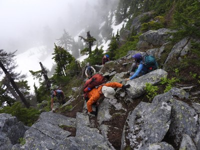
Granite Mountain to Low Mountain to Hemlock Pass: Mixed snow and dirt. Areas of steep snow, dirt, and heather. Many areas of wet brush (tree branches mainly). Areas of melting snow over talus fields.
Denny Creek Trail: Switchbacks to Hemlock Pass mostly snow covered. Running water on trail in many places. Log footbridge at upper creek crossing is GONE. There is one went, slick, narrow log to crawl across on hands and knees. Otherwise, must ford the creek. Lower crossing (water slide) has logs to cross at the top of the water slide, a little upstream of where trail meets the creek.
We set off from the Pratt Lake/Granite Mtn TH at 5:20am. The trail was snow free until the ridge. We hiked up the trail to 5200 feet/3.8 miles, where the trail reached the ridge. From here, we dropped into the snowy north basin and crossed through the basin, descending and traversing until we reached the north ridge of Granite. Now we were dropping back into the clouds again, and for good. We then continued north down the ridge, and we tried to stay in the middle of the ridge, but occasionally would have to go around to the right of some small cliff bands. Just be careful not to get lured too far to the right down snow gullies that drop down to Denny Lake. We encountered a lot of steep snow and brush to push through. At 4.75 miles we reached the Granite-Low saddle at 4500 feet, just above the north end of Denny Lake.
We continued north and ascended the south ridge of Low Mountain, hiking through mostly open forest to start but some brush in spots, pretty much staying up the middle. The ridge gets narrower as you get higher, especially after 4800 feet. So the brush gets more constant, but still stay on top of the ridge as you go up. At 5200 feet/5.7 miles, we reached the upper part of the ridge. We went up and over a bump of talus. After this on the ridge we had some areas of rock scrambling needed in places. If the ridge gets craggy, go around to the right/east, as the left/west is all cliffs. We went around to the right/east of the false summit and continued a bit more up to the summit, at 6 miles and 5 hours and 20 minutes in. Unfortunately we were clouded in.
The north side of the summit is a cliff. We found a way down off the right/east side of the summit where we dropped a bit maybe 40 or so feet and then traversed across some dirt and mossy rocks to place us directly below the north cliff of the summit. But ahead on the ridge appeared to be more cragginess and brush, so we dropped a bit off the right side to try to get around this last bit of the higher summit ridge. We had to go down pretty steep and slick heather, dirt, and snow but it led to an open snowfield (talus field when no snow). We traversed down across the top of this staying just below the trees of the ridgeline, until we fond a good place to rejoin the ridge, with the craggy stuff behind us.
From here on we did our best to stay atop the ridge as we headed north toward Hemlock Pass. Much of the ridge was pretty brushy and wet. Sometimes we went around some obstacles to the left, and sometimes to the right. When we hit 4700 feet, we saw good looking snow below to the right were the trail should be, so we dropped off the ridge bit before Hemlock Pass and we reached the trail a bit below the pass.
Much of the trail's switchbacks are still snow covered, so hikers use caution and keep an eye out for switchbacks obscured by snow so you do not get off trail. There are some switchbacks you can cut on the snow. As usual, there is a lot of running water on the trail in many places. At the upper creek crossing where a log footbridge used to be, the log is gone! Was it washed away? The only two options are to literally crawl across a different wet and narrow log (which I did), or ford the creek. At the lower crossing (the water slide), there are some logs well placed to cross the upper section of the waterslide, a little upstream from where the trail meets the creek.
11.5 miles, nearly 4700 feet of gain, about 10 hours. GPS track/trip stats: http://www.movescount.com/moves/move225147229
 Chris Pribbernow