Trip Report
Alpine Scramble - Kyes Peak
A very long 18 mile/18 hour day up Kyes Peak, involving complex navigation and bushwhacking but also gorgeous views and scenery
- Wed, Jul 25, 2018
- Alpine Scramble - Kyes Peak
- Kyes Peak
- Scrambling
- Successful
-

- Road suitable for all vehicles
-
Last 2 miles of road to TH still closed requiring a walk or bike (we walked). Trail to Virgin Lake is fine. From there, well, read below.
First of all, here is the GPS track: http://www.movescount.com/moves/move232049176
In regards to the 3 most major splits in our track, From SOUTH to NORTH: Take west track for the first one, take east track for the big second one (partially, at least), and for the last one near the top take either depending if you prefer snow or rock. I will explain in my report below.
We started out from the makeshift TH at the road intersection at 5:15am and hiked 2 miles to the actual trailhead, getting there around 6am. From there we hiked up the switchbacks of the trail 3 miles to Virgin Lake, arriving a bit before 8am. Here we refilled water despite the unappealing appearance of the water.
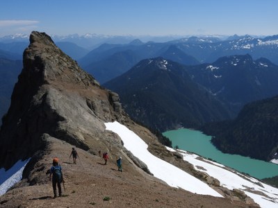
We continued around the lake and just past a no campfire warning sign posted to a tree, we found the faint spur trail leading off to the right. We followed the trail pretty easily up the ridge until about 1 mile up the ridge from the lake where the trail seemed to leave the ridge continue off the right side of the ridge. Instead, we continued on the ridge and slightly left to skirt around to cliffs and we came to a very exposed scramble ledge to get up. The challenge here were the big thick tree branches awaiting us on top of this move. There was no way around the branches and we had to struggle through them. The branches grabbed hold of my ax and poles on my pack and tried to push be backwards off the cliff. They did manage to knock my water bottle loose and claim that as their consolation prize. After that move we climbed a bit more steep terrain and up toward a tall sharp rock pinnacle and arrived on a much nicer open ridge trail that we were able to follow, with some scrambling in places. Views opened up down to Blanca Lake, out to Columbia Peak, and Glacier Peak, Mt. Daniel and Hinman, Mt. Stuart.
At 6.5 miles/5500 feet, leave the ridge trail and cross over the left side of the ridge to find a path that leads down a big open heather slope descending nearly 200 feet to a talus field. (On the way in we stayed on the ridge trail a bit too long before dropping down) . From about 5300 feet on the talus field it is a choose your own adventure through the first of two big bushwhacks until we got just before the big saddle of the ridge at about 5400 feet. Now if you look at my GPS track this is the very big 2nd split. Just ignore our lower track completely to avoid another major bushwhack we had to deal with. Instead, take the high road and stay on the ridge. Fight through a bit more brush and go to the saddle where you will regain the ridge trail. Follow the trail up the pretty steep ridge as you leave the approach ridge and climb onto the slopes of Kyes Peak. At 5900 feet leave the ridge and split the difference of our two tracks and go out onto the big vast open glacial slopes of talus, heather, and cascading streams. Here is a great place to refill water.
Traverse up a large snowfield (or maybe it will be more of the same heather/talus later in summer) up to a high saddle on the ridge at 6600 feet. To the south of this saddle is a sharp horned peak that looks fun to scramble up if you have time. We continued ascending the ridge north and reached another giant snowfield which you can either ascend or follow the dry ground on the ridge to the summit block. The summit block has some loose rock but is straightforward. We arrived at the summit 10 hours after leaving the cars, 7 hours from Virgin Lake. The views were quite remarkable, especially of the Matterhorn of Sloan Peak.
On the way down once below the high saddle at about 6200 feet on the lower snowfield we tried to stay on the ridge but cliffed out. Wait until 5900 feet until you regain the ridge to descend to the saddle. We did not return to Virgin Lake until 8:30, over 12 hours after leaving the lake for the summit. We hiked out the last endless 5 miles with our headlamps in the dark, returning to the cars at 11-11:15pm. 18 miles, 18 hours, over 7300 feet of elevation gain.
Trip report with photos: http://www.nwhikers.net/forums/viewtopic.php?t=8027757
 Chris Pribbernow