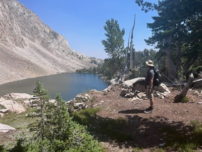
White Clouds Wilderness Loop
Visit more than 25 alpine lakes and the high alpine terrain of Idaho’s spectacular Sawtooth Mountains and White Clouds Wilderness Area. The hiking is strenuous and challenging, but the scenery and views are breathtaking!
Getting There
Drive to the Fourth of July Trailhead, near Stanley Idaho. It's 620 miles and roughly a 12-hour drive from Seattle.
Overnight options include
- Stanley Idaho, ~1 hour from the trailhead.
- Bellevue, Hailey or Sun Valley Idaho. ~2 hours from the trailhead.
- At the trailhead, first-come, first- served primitive camping may be available at the trailhead. There is a vault toilet but no potable water. Fourth of July Creek is nearby.
On the Trail
Though it would be difficult to pick a single favorite from among the dozens of mountain ranges that draw the admiration of Idaho hikers, you could make a strong case for the White Cloud Peaks as the best of the lot. All of the trails in this range take you through scenery that is so spectacular it simply defies description.
Put simply, alpine scenery just doesn’t get much (or, perhaps, any) better than what you will find in the upper basin of the Big Boulder Lakes. Here, there is the perfect mix of deep-blue alpine lakes, wildflower-covered meadows, small waterfalls, rock-garden wildflowers, and, most of all, dramatic peaks in every direction.
Backpacking Idaho: From Alpine Lakes to Desert Canyons, 2nd ed by Douglas Lorain
Suggested Itinerary
Day 1: Hike from Fourth of July Trailhead to Born Lakes: 4.5 miles, 1,500 feet of elevation gain. The first 1.3 miles are open to motorcycles. The route follows the Lake Washington Lake Trail east to the Antz Basin Trail where it turns north. A well-established, but unnamed trail, heads east from the meadow of Antz Basin to Born Lakes (also called Boorn Lakes), where there is good camping.
Day 2: Hike to Hatchet Lake: 9 miles, 1,800 feet of elevation gain. This day includes a steep, rocky, off-trail section over the ridge between Born Lakes and the dramatic Four Lakes Basin. According to Douglas Lorrain in Backpacking Idaho: From Alpine Lakes to Desert Canyons:
Reaching the Four Lakes Basin requires a careful descent of a steep slope. At the top of this slope is a large snowfield with overhanging cornices that are often present well into August. It is usually possible, however, to work your way around this snowfield by going farther to the right. Once around the snowfield, the rest of the downhill isn’t particularly dangerous, but it is very steep and does require steady nerves and maybe using your hands once or twice to balance yourself.
From Four Lakes Basin, follow a way trail to Quiet Lake, then Scree Lake and Shallow Lake before joining an established trail. This trail leads us past more lakes: Scoop, Hammock, Tiny, Hourglass, Lodgepole, Sliderock, and Shelf Lakes to camps at Hatchet Lake—15 lakes in one day!
Day 3: Hike to Walker Lake: 9.8 miles, 2,600 feet of elevation gain. Hike past Willow Lake, before reaching an intersection and hike north along the Livingston Mill/Castle Divide Trail (open to motorcycles) to the Big Boulder Trail (closed to motorcycles). Turn west, continue to the intersection with Walker Creek Trail, turn right (north), and hike to Walker Lake.
Day 4: Leave overnight gear behind and explore off-trail through the Upper Big Boulder Lakes area, possibly visiting Hook, Cove, Sapphire, and Cirque Lakes. It's roughly 5.5 miles and 1,300 feet of elevation gain.
Day 5: Retrace the route to Hatchet Lake: 9.8 miles, 2,300 feet of elevation gain. Consider a side trip to Island Lake that adds ~1.0 miles and 300 feet of elevation gain.
Day 6: Hike to Upper Chamberlain Lake: 7.5 miles, 2,050 feet of elevation gain. Hike Livingston Mill/Castle Divide Trail enjoying views of Castle and Merriam Peaks and a possible off-trail side trip to Castle Lake. Then hike over Castle Divide to a junction with Chamberlain Creek Trail and follow it to Lower Chamberlain Lake. Climb to the more-scenic Upper Chamberlain Lake to camp directly below Castle Peak.
Day 7: Return to Fourth of July Trailhead: 10 miles, 1,500 feet of elevation gain. Retrace the route to Lower Chamberlain Lake and then hike south on the Livingston Mill/Castle Divide Trail to the intersection with the Washington Lake Creek Trail. Follow it north, past Washington and Fourth of July Lakes to the trailhead.
Notes
- Guidebook: Backpacking Idaho: From Alpine Lakes to Desert Canyons, 2nd ed by Douglas Lorain (Wilderness Press 2015).
- Guidebook: Trails of the Sawtooth and Boulder-White Cloud Mountains, 6th ed by Margaret Fuller (Trail Guide Books 2017).
- With elevations ranging from 7,800 ft to 10,300 ft, this is a high-elevation trip for those who live near sea level.
- Suitable Activities: Backpacking
- Seasons: July, August, September
- Weather: View weather forecast
- Difficulty: Very Strenuous
- Length: 56.0 mi
- Elevation Gain: 13,000 ft
- 10,300 ft
-
Land Manager:
Sawtooth National Forest
Cecil D. Andrus-White Clouds Wilderness, Sawtooth National Recreation Area (SNF)
- Parking Permit Required: Northwest Forest Pass
- Recommended Party Size: 12
- Maximum Party Size: 12
- Maximum Route/Place Capacity: 12
- Adventure Maps Sawtooth & White Cloud Mountains Trail Map
- Trails Illustrated Sawtooth National Recreation Area
- USGS Boulder Chain Lakes, ID
- USGS Washington Peak, ID
- USGS Livingston Creek, ID
There are no resources for this route/place. Log in and send us updates, images, or resources.
