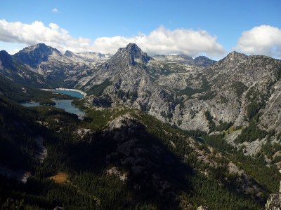
Wedge Mountain
A fun hike and scramble just outside of Leavenworth that offers outstanding views into the Enchantments. High clearance vehicles are an absolute must.
Getting There
Drive SR-97 to 4 miles south of its intersection with SR-2 and turn west onto Forest Road 7300 (Mountain Home Ranch Road). Follow Forest Road 7300 to a right turn up a steep hill, signed “Mountain Home Road/Leavenworth” and continue 2.5 miles and left onto Forest Road 7305. Contine along a moderately rough and rutted road, following the most-used track. At a fork at ~4,000 ft go straight ahead and follow this to large parking area at ~4,500 ft. The last section is narrow, brushy, and requires a high-clearance vehicle and good nerves. It may be impassible and may be best to walk it.
Ascent Route
From the parking area, hike up the steep, well-used road going up the ridge to the southwest which becomes a trail. Continue on the trail to 5,200 ft and a horse packers’ campsite and corral. Here there are two trails. Take the path through the horse packers’ campsite and up the ridge. Do not take the path to the left; it goes about half a mile to a collapsed tin-roofed cabin.
Break into open burn area recovering from the Rat Creek fire. Follow the most obvious boot path, often overlain by fire-fallen trees, and avoid soical and side trails. It ascends to ~6,200 ft at a point overlooking the Allen Creek Basin on the east and Nada Lake over the ridge-top and down toward the west. Continue south along the ridge and gradually ascend to avoid cliff bands at the foot of Wedge Mountain. Scramble over a slight rocky bench and over a cresting rise at right angle to the main ridge to arrive at a fine granite-paved spot just above a gully that leads down to the base of the rock scramble. Clean granite ledges, slabs, trees, and narrow shallow gullies are options to the summit. Here is a good spot to size up your party’s requirements and assess the final challenge, which is short but real and sweet.
Notes
- Wedge Mountain, designated on the Leavenworth USGS 7.5-min map, is not correct. The Wedge Mountain in this route/place, also called South Wedge Mountain, is located on the Blewett Pass USGS 7.5 min map.
- The road may be impassible, adding some distance to this scramble.
- Recent increased use has caused many social and side trails to develop and there is no formal trail maintenance. Please be sure to stay on the main boot path.
- Suitable Activities: Scrambling
- Seasons: May, June, July, August, September, October
- Weather: View weather forecast
- Difficulty: Strenuous 3, Technical 4
- Length: 8.0 mi
- Elevation Gain: 3,000 ft
- 6,885 ft
-
Land Manager:
Okanogan-Wenatchee National Forests
Alpine Lakes Wilderness, Wenatchee River Ranger District (OWNF)
- Parking Permit Required: Northwest Forest Pass
- Recommended Party Size: 12
- Maximum Party Size: 12
- Maximum Route/Place Capacity: 12
- USGS Blewett
- USGS Leavenworth
- Green Trails Alpine Lakes East (Stuart Range) No. 208SX
There are no resources for this route/place. Log in and send us updates, images, or resources.
