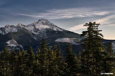
Twin Sisters/Twin Sisters Traverse
The Twin Sisters Traverse is a Grade II, Class 3 climb.
Getting there
Take Exit 232 (Cook Road) off of I-5 at Burlington. Turn east to Sedro Wooley and junction of SR-20. Turn left and continue to SR-9. Go north on Route SR-9 to Acme. Route-finding from the Acme grocery store to the Trailhead, 12.5 miles away, is the biggest challenge. Turn right on Mosquito Lake Road, 0.2-0.3 mile past the store and go 9 miles to steel bridge. Drive another 0.75 mi to Forest Road 38. Turn right (south) on Forest Road 38 for approximately 5 miles. Stay right at the Y. Park at the gated bridge across the Nooksack even if the gate is open (1,200 ft).
APPROACH
Cross bridge and hike up the main logging road; do not take any logging roads branching to the left. The four logging roads branching to the right are as follows: 1st - yellow gate across road (.25 mi from cars). 2nd - recently cut road. 3rd - heavily overgrown, abandoned road. 4th - abandoned, but not very overgrown (2,600 ft, 2.5 mi from cars). Take this 4th road. At about 0.5 mi on this abandoned road, go over a tank trap and continue until you reach a fork in the road (3,000 ft), and take the left branch. (The right branch trends downhill toward Dailey Prarie.) Continue until you come to another abandoned road off to the left. A large dead tree lies near the entrance to this road and a gravel diversion blocks its entrance. Follow this road, which will switchback to the trailhead around 4,100 ft. Allow 2-3 hr.
ASCENT ROUTE
Follow North Twin Sister (NTS) West Ridge route described in Basic Climbs Guide to summit at easternmost crest of NTS. Descend South Face of NTS, staying to sides of southeast gully to minimize rockfall, to the col, (5,800 ft) between the Twin Sisters. Move south on the Sisters Glacier to the bergschrund (which may be problematic later in the season) and climb up, preferring snow to rock when presented with the choice) to the crest of North Ridge of South Twin Sister (STS) and on to STS summit.
DESCENT ROUTE
Return to the col between the Twin Sisters, via either South Twin Sister (STS) West Ridge or, in early season, the STS North Face (steep snow; watch for avalanche hazard). The STS West Ridge can become technical (be prepared to rappel) if ridge crest proper is followed. 200 yards from STS false summit, move off ridge to the right; traverse back to ridge crest 500 ft lower, then follow ridge crest via cairn route to left and down. Descend the cirque basin toward its right margin back to base trails (at level of clear-cut, traverse right) and spur roads.
TRIP PROFILE
| SEGMENT | TIME (HR) | ELEVATION GAIN (FT) |
|---|---|---|
| Seattle to Trailhead | 2 | |
| Trailhead to North Twin Sister | 2-4 | 3,150 |
| North Twin Sister to South Twin Sister | 3 | 400 |
| South Twin Sister to Trailhead | 4 |
EQUIPMENT
Ice ax, crampons. Pickets or snow flukes in early season. Minimal rack.
NOTES
This athletic one-day traverse climbs the marvelous rough olivine of the North Twin Sister (and the somewhat crumbly South Twin). These peaks stand out to the west of the main Cascade Range and are seen prominently from the Mount Baker Highway. Avoid aggravation by scoping out the current road status ahead of time and reviewing recent trip reports.
A 1995 report stated, ‘Roads have no signs; following boot tracks led us to the right place.’
A 1983 report noted, ‘For some extra fun, there is nice rock climbing on Arrowtip Tower on the lower part of North Ridge of South Twin Sister.
Get an early start.Some parties never actually rope up.
- Suitable Activities: Climbing
- Seasons: May, June, July, August, September, October
- Weather: View weather forecast
- Difficulty: Intermediate Mountaineering Climb
- Elevation Gain: 3,550 ft
- 6,932 ft
-
Land Manager:
Mount Baker-Snoqualmie National Forest
Mount Baker Wilderness, Mount Baker Ranger District (MBSNF)
- Parking Permit Required: Northwest Forest Pass
- Recommended Party Size: 12
- Maximum Party Size: 12
- Maximum Route/Place Capacity: 12
- USGS Twin Sisters Mountain
- USGS Cavanaugh Creek
- USGS Canyon Lake
There are no resources for this route/place. Log in and send us updates, images, or resources.
