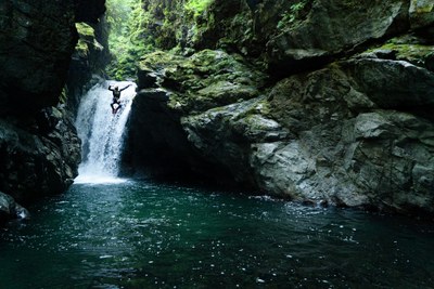
Thundercat Canyon
A gorgeous intermediate canyon near Baker Lake. Late in the season, it is rated v3a4III, the only time moderate flows occur. It typically runs at a5 (advanced) through early August.
GETTING THERE
From SR-20, turn north onto Baker Lake Rd (Forest Road 11), then turn right onto Baker River Road (Forest Road 1106), and drive to the Baker Lake Dam. After passing a campground and crossing the dam, park to the side near the large gate. After the gate, the road passes through land owned by mix of State DNR, PSE utility, and private timberlands. It is open for recreational non-motorized access.
APPROACH
Hike south for about 3.5 miles. This road is partially paved and taking bikes would certainly make the trip shorter and would help mitigate the mosquitoes. The road ends at the creek right at the point the bedrock canyon begins. It is possible to carefully scramble on large rocks to skirt around the first pool. Just below are the remains of the old bridge and the committing section of canyon begins.
DESCENT
Special Notes: Always have one person check pool depth before jumping. This canyon is very slippery. Scrambles and/or partner assists may be required to reach anchors that have been placed above the high water line.
- Jump 1: DCR (Down Canyon Right): 15-foot jump. Check the flow and hydraulics here. If the flow is too raucous, consider bailing or running the lower section of the canyon only, which is not as committing.
- Rappel 1 DCR: 12 feet, single bolt anchor. A scramble is required to reach this anchor. In high flow, the current can be strong here. This short drop has been jumped.
- Rappel 2 DCR: 40 feet, bolted anchor. A scramble/partner assist may be required to reach this anchor. Rappel the entire way or stop at the ledge and jump DCL.
- Jump 2 DCL (Down Canyon Left): 22-foot jump from ledge into a large pool. No anchor.
Midpoint: The canyon opens up here briefly and allows access on both sides. Note this spot, it is one potential option for the exit.
- Jump 3 DCL: 15-foot jump into deep undercut pool. You must jump out far to clear a rock ledge below.
- Rappel 3 DCL: 30-foot single bolt anchor. Partner assist may be needed to reach this anchor.
- Jump 4: 15-foot jump into a narrow slot leading into large pool. It is also possible to slide this waterfall. This section can be bypassed completely by downclimbing.
- Jump 5 DCL: 20-foot jump from a ledge into a very deep pool. This pool is very cool to dive down and check out with a mask.
- Jump 6: 8-foot jump into final pool. If the flow is too strong to safely approach the lip, simply exit the canyon to the left.
EXIT
Option 1: From the broad river gravels, exit canyon left. Ascend into the old growth forest and follow the rim of the canyon on south side back to the midpoint. There is no trail, so this is a bush walk. After reaching the midpoint, cross the stream to the north side, and head uphill to regain the approach road. Approaching the top by the road, it can get quite steep and there is some loose scree to scramble past. Return via the road.
Option 2: Walk down the river gravels until the river curves to the left. Climb up the embankment and scramble up through the forest 15-20 minutes, skirting the edge of an old landslide on the right. After topping out, find a very old road. Turn left and walk about 500 feet until the road curves to the right and makes a U-turn, where the old road becomes more open. Follow this road back to the main road.
EQUIPMENT
Standard canyoning gear including webbing, a wrench and replacement quick links.
TRIP PROFILE
- Rappels: 3-4; plus 6-7 jumps/slides
- Longest Rappel: 40 feet
- Approach: ~ 3.5 miles
- Exit: ~1 mile
- Time: 5-8 hours total
NOTES
- This canyon is rated v3a4III late in the season, the only time one will find moderate flows here. It typically runs at a5 (advanced) through early August.
- For more information and recent trip reports from the community, visit the Thundercat listing at ropewiki.
- Suitable Activities: Canyoning
- Seasons: August, September
- Weather: View weather forecast
- Difficulty: Intermediate Canyon
- Land Manager: Washington State Department of Natural Resources
- Parking Permit Required: None
- Recommended Party Size: 6
- Maximum Party Size: 8
- Maximum Route/Place Capacity: 8
- USGS Lake Shannon
- Green Trails Mount Baker Wilderness Climbing No. 13SX
- USGS Welker Peak
There are no resources for this route/place. Log in and send us updates, images, or resources.
