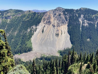
South Slide Mountain
A moderate scramble of 12 miles with 2,500 feet of elevation gain. It can be done as an out-and-back trip or a traverse. Enjoy spectacular and changing views much of the way, and wildflowers which are abundant in late summer.
getting there
Sunrise Point (south)
Drive SR 410 4.5 miles south of the Crystal Mountain ski area turnoff and turn right on Sunrise Park Road. Drive 13 miles to Sunrise Point (6,100 ft).
Sun Top Trail (North)
Drive SR 410 9 miles south of Greenwater, and turn right on Forest Road 7160. Drive ~7 miles to 4,300 ft and park where Forest Road 7160 intersects the Sun Top Mountain Trail (No. 1183). Depending on snow, you may have to park lower at 3,830 ft where Forest Road 7160 also intersects the Sun Top Trail, ~5.6 miles on Forest Road 7160. This road is rough and a high-clearance vehicle may be required navigate it or you might need to park lower on the road at ~2,600 ft. A Northwest Forest Pass is required to park here.
approach & ascent
Sunrise Point (south)
9 miles round trip, 4,100 feet of elevation gain, Strenuous 3 | Technical 3
Take the Palisades Lake Trail and in ~0.3 mile take the right fork (north) toward Clover Lake/Upper Palisades Camp. Continue on the trail for another 3 miles to ~6,100 ft, just before reaching Upper Palisades Lake. This is the last water source until the "unnamed" Buck Lake. Leave the trail and follow a boot path to Brown Peak (6,322 ft). From the summit of Brown Peak turn north and continue on the ridge on a good boot path to South Slide Mountain (6,620 ft, labelled Point 6620 on the USGS map). For a bit more of a challenge, continue north to the the next peak on the ridge, Middle Slide Mountain (6,620 ft).
Sun Top Trail (north)
7 miles round trip, 3,300 feet of elevation gain, Strenuous 3 | Technical 4
Follow the Sun Top Trail, leaving it at Buck Creek (4,970 ft). A boot path heads south into the park. Follow it to the "unnamed" Buck lake. From the far side of the lake, ascend the ridge and follow it North Slide Mountain (6,339 ft) and then continue scrambling south to the higher peak. The ridge is Technical 3 or Technical 4 difficulty rock scrambling, with substantial loose rock as you approach Middle Slide Mountain (6,620 ft). The west side of the ridge generally has less exposure.
slide mountain traverse (south to north)
12 miles one-way, 2,500 feet of elevation gain, 5,000 feet of elevation loss, Strenuous 3 | Technical 4
Ascend to the South Slide Mountain summit as above. Descend with great care on the ridge or just west of it above the top of the big slide area that gives Slide Mountain its name. The ridge is Technical 3 difficulty rock scrambling, with less loose rock and more scrambling options as you approach North Slide Mountain (6,339 ft).
You can descend loose scree into the valley to the east, but that is longer and slower, and considerably less aesthetic. The better option is to continue northeast over the next knoll. Game trails abound, including down to the "unnamed" Buck Lake (5,800 ft). From the lake, proceed north to headwaters of Buck Creek on game trails as able, with some brush, until intersecting Sun Top Trail. Turn right and follow it to trailhead, watching for horses and mountain bikes.
notes
- There are three points on the mountain:
- South Slide Mountain (6,620 ft), labelled as Point 6620 on the USGS and Green Trails maps. It's an easy off-trail hike from Palisades Lakes.
- Middle Slide Mountain (6,620 ft), not labelled on maps. This one is most popularly recognized as Slide Mountain and requires Technical 3-4 difficulty scrambling to reach its summit from any direction.
- North Slide Mountain (6,339 ft), the "official" Slide Mountain per the USGS and Green Trails maps.
- The route is usually snow-free in late July, even in a relatively late snow-melt year.
- Suitable Activities: Scrambling
- Seasons: July, August, September
- Weather: View weather forecast
- Difficulty: Strenuous 2, Technical 3
- Length: 12.0 mi
- Elevation Gain: 2,500 ft
- 6,620 ft
-
Land Manager:
Mount Rainier National Park
Mount Rainier Wilderness
- Parking Permit Required: National Park Entrance Fee
- Recommended Party Size: 12
- Maximum Party Size: 12
- Maximum Route/Place Capacity: 12
- USGS White River Park
- Green Trails Greenwater No. 238
- USGS Greenwater
- Green Trails Mt Rainier East No. 270
- Green Trails Mount Rainier Wonderland No. 269SX
This is a list of titles that represent the variations of trips you can take at this route/place. This includes side trips, extensions and peak combinations. Not seeing a title that fits your trip? Log in and send us updates, images, or resources.
- South Slide Mountain via Sunrise Point
- South Slide Mountain via Sun Top
- Middle Slide Mountain
- Middle Slide Mountain via Sunrise Point
- Middle Slide Mountain via Sun Top
- North Slide Mountain
- Slide Mountain
- Slide Mountain via Sunrise Point
- Slide Mountain via Sun Top
- Slide Mountain Traverse
There are no resources for this route/place. Log in and send us updates, images, or resources.
