South Fork Snoqualmie River
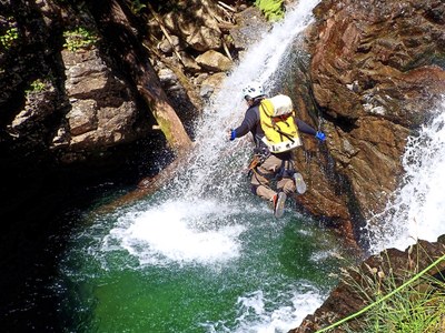
A fun, splashy canyon with lots of swimming and waterpark features such as jumps and slides up to 20 feet (all optional). This half-day descent culminates in a scenic 100-foot rappel down Franklin Falls, a popular destination for waterfall enthusiasts. This canyon is usually run in August and September when it is rated v3a4 III.
GETTING THERE
Take Exit 47 off of I-90 to Exit 47 (Asahel Curtis/Denny Creek), turn left (north), proceed under the highway, and then turn right (east) onto Forest Road 9034. In 0.3 mile, turn left onto Forest Road 58. Proceed 3.8 miles and park at a small pullout on the left just before a hairpin turn. Leave the exit vehicle(s) here.
To reach the start of the canyon, continue on Forest Road 58 another 0.7 mile until arriving at a gravel pullout next to a low rock wall on the left side of the road.
APPROACH
The first feature, "Fall into the Wall" falls, is visible from the low rock wall. Suit up at the cars and follow a short social trail to the river.
DESCENT
There are three to five rappels and many opportunities to jump and slide in the river. Be sure to check depth before jumping. The first part of the descent is the waterpark:
- Jump 1: 10 feet DCL (Down Canyon Left) from rock platform below "Fall into the Wall" falls. The target is the pool on the far edge of the whitewater, avoiding an underwater boulder. There is an option to rappel 15 feet.
- Slide 1: 18 feet consisting of an 8-foot slide and a 10-foot drop into the pool below. The flow pushes you towards the wall DCR (Down Canyon Right) as you drop off the slide. There is an option to jump (see Jump 2 below) and an option to rappel 25 feet.
- Jump 2: 20 feet DCL from the upper rim into a narrow gap that "bells out" to become the widest part of the pool below. Slide 1 and Jump 2 are repeatable by exiting the pool DCL and scrambling back up and around via a social trail.
- Continue downstream by swimming, down-climbing, jumping and sliding as desired. There are several jumping opportunities DCL and DCR into deep pools.
The final technical sequence is the approach to and descent of Franklin Falls:
- Rappel 1: 30 feet DCL from a tree into a large pool
- Rappel 2: 30 feet DCL from a bolt. First into a deep pothole and then across a rock platform to the lip of Franklin Falls. Set up a retrievable safety line to approach the edge of the falls.
- Rappel 3 (Franklin Falls): 100 feet DCL from bolts. The bottom is the terminus of a popular trail so expect to encounter hikers viewing the falls from below. The first person down should rappel with the rope bag while deploying the rope to avoid the rope hitting people below if the rope were thrown.
EXIT
Exit the canyon by following the main trail about 600 feet until a side trail veers off the main trail DCL. Follow this side trail for 300 feet up to the road and the exit vehicles.
EQUIPMENT
Standard canyoning gear including replacement webbing and quick links. This canyon is highly aquatic and requires long swims in very cold water. Plan for significant thermal protection and ensure all team members have their flotation set before entering the canyon. Goggles or dive masks are helpful for checking pool depth for jumps.
TRIP PROFILE
- Rappels: 3-5, plus jumps and slides
- Longest Rappel: 100 feet
- Approach: 100 feet
- Exit: 0.2 miles
- Time: 3-5 hours total
NOTES
- This canyon is rated v3a4 III at moderate water levels typically seen in August and September.
- For more information and recent trip reports from the community, visit the South Fork Snoqualmie River listing at ropewiki.
Information for leaders
Scheduling
- Any course field trips scheduled for the South Fork Snoqualmie River must stay in the upper creek and exit before Franklin Falls.
- Because Franklin Falls is a popular hiking destination, trips should be scheduled for weekdays only. Please do not schedule trips on weekends or holidays.
- Suitable Activities: Canyoning
- Seasons: August, September
- Weather: View weather forecast
- Difficulty: Basic Canyon
- Length: 0.6 mi
- Elevation Gain: -250 ft
-
Land Manager:
Mount Baker-Snoqualmie National Forest
Snoqualmie Ranger District (MBSNF)
- Parking Permit Required: Northwest Forest Pass
- Recommended Party Size: 6
- Maximum Party Size: 12
- Maximum Route/Place Capacity: 12
- Green Trails Snoqualmie Pass Gateway No. 207S
- Green Trails Snoqualmie Pass No. 207
- USGS Snoqualmie Pass
There are no resources for this route/place. Log in and send us updates, images, or resources.
