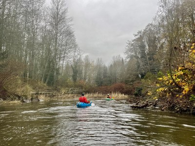
Samish River: Belfast to Edison
Samish River: the forgotten waterway. The Samish river runs through the rich farm lands of the Skagit Flats, providing access to the wildlife and history of this unique place. Start in a sprightly little river, pass through broad flats, and finish in a salt water bay.
Flow:
- Gauges: NOAA SAMISH - NEAR BURLINGTON (SAMRW1) and USGS SAMISH RIVER NEAR BURLINGTON
- Recommended Range: 150-300 CFS. At the lower end of the range more wood hazards will require portaging. At the higher end there will be less eddy service and higher risk in navigating through wood hazards.
- Gradient: 5 feet/mile. The last 4 miles from Thomas Road bridge to Samish Bay is essentially flat and subject to tidal forces.
- Tides: Check SAMISH BAY TIDE CHARTS when planning a trip. An ebbing tide is useful in making headway in the flats below Thomas Road bridge, especially in a headwind.
Put-Ins & Take-Outs
- Samish River Water Access: A WA Fish and Wildlife water access site at Hwy 99’s bridge over the Samish River. On the south west side of the bridge, a trail leads to a 20 ft wide gravel beach launch site. There is a parking site 300 ft north of the bridge, on the west side of Hwy 99. Parking may also be permitted along the road, south west of the bridge.
- Jolly Road: The WA Fish and Wildlife water access information describes parking at the west end of Jolly Rd. This may also provide river access.
- Bay View-Edison Rd: Park along the Bay View-Edison road, west of the Samish River bridge. Access the water on the Bridge’s south west side.
- Edison: Take out along the banks behind the Breadfarm store. There is no parking at this takeout. Park appropriately in the town of Edison.
On the River
Highway 99 Samish River Bridge to Bay View-Edison Road
9.5 miles
From the launch site, the river is small (20-30ft wide) and intimate with brush along the bank and trees overhanging. The current moves along at 2.0 mph. There are channels to follow and wood to avoid. Houses line the shore at times. Views are local - the river and vegetation along the side. Look for waterfowl in the river and bald eagles perched in trees above the river.
There is significant amount of wood in the water. Most is easy to paddle around. In some places there may be river-spanning wood. The current is slow enough that these can be approached slowly. Some you may be able to portage over and some may require a walk along the bank.
About half way to the Bay View Edison road, downstream from Allen, the river character begins to slowly change. Current slows. Brush along the banks gives way to grasses. The channel widens. Distant views become more common. Look for bald eagles, ducks, cormorants, kestrels, beaver, and other creatures of the field. Signs of the historic working waterway appear.
Wood is unlikely in this section. At the bridge, current may have slowed to 0.0 to 1.0mph, depending on the tide.
Bay View Bridge-Edision Road to Edison
2.5 miles
This section takes you into saltwater of Samish bay. There are extensive tidal flats so plan to transit this area at high tide. The required tide height has not been measured. 6ft tide or higher is likely to suffice.
Paddle under the bridge. Here, there are many signs of historic human use of the waterway. Follow the right hand shore around a headland and enter Edison Slough. Take-out behind the Breadfarm store. There is a steep bank here.
The town of Edison has many good restaurants and a brewery for an after-paddle meal.
Notes:
-
- While the water is Class I, the presence of wood hazards requires good boat handling. This is a suitable trip for an experienced flat water paddler. Techniques to surmount wood hazards, such as seesawing, the plank, and the limbo, are useful.
- There is a fish hatchery and low head dam a short distance upstream from the Old Highway 99 Bridge. The river is non-navigable above the fish hatchery due to extensive wood downfall.
- The Samish River supports a large variety of fish and is home to one of Washington's larger fall King Salmon runs. The Samish River has runs of five Salmon and three Trout species.
- The Samish is rare in that it is one the only small rivers that drains directly into the Puget Sound. The 7 major rivers systems that feed the Puget Sound are the Nooksack, Skagit (Sauk and Suiattle), Stillaguamish, Snohomish (Skykomish and Snoqualmie), Duwamish (Green), Puyallup (White), and Nisqually.
- Suitable Activities: Packrafting
- Seasons: January, February, March, April, May, June, November, December
- Weather: View weather forecast
- Difficulty: Class I River
- Length: 12.0 mi
- 61 ft
- Land Manager: U.S. Fish & Wildlife Service
- Parking Permit Required: Discover Pass
- Recommended Party Size: 6
- Maximum Party Size: 12
- Maximum Route/Place Capacity: 12
There are no resources for this route/place. Log in and send us updates, images, or resources.
