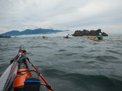
Quatsino to Tofino, Vancouver Island
Sea kayak along a long stretch of the northern section of the west coast of Canada's Vancouver Island, rounding the Brooks and Hesquiat peninsulas, passing Kyuquot sound, Esperanza Inlet, Nookta Sound, and Clayoquot Sound. It's roughly 200 nm and takes up to three weeks.
Launch Points
launching from Quatsino Sound
- Winter Harbor In many ways, is best. It saves paddling the length of Quatsino Sound, which takes two or three days. It is also a reliable place to use a float plane for a car shuttle.
- Coal Harbor provides easiest road access and includes a paddle through Quatsino Narrows. Paddling the narrows is not difficult but it must be done at favorable tide. Float plane access is good.
- Port Alice allows you to avoid the Quatsino Narrows. Float plane access is good
- Gooding Cove on the south side of Quatsino entrance is a BC Marine Trails site with road access.
- Side Bay is a BC Marine Trails site with road access. This is the southernmost starting point.
- San Josef Bay is north of Quatsino and may be a good choice if you have never paddled its coast.
Take Out Points
- Tofino is the takeout point.
Car Shuttle
Arranging the Car Shuttle is the major logistic challenge. It is a full day's drive from any of the launch points to Tofino. Placing all cars in Tofino so no shuttle is required at conclusion of the trip is best. One option is to coordinate with others who are also vacationing on Vancouver island and have them shuttle your cars for you. Another option is to use a float plane from Tofino to Winter Harbor to get all drivers back up to the launch point. There are two float plane operators on the west coast: Tofino Air and Air Nookta (out of Gold River).
Parking in Tofino
There is long term paid parking in Tofino for up to two (2) weeks. If you are going to be out for longer than that (and probably longer than one week) it is best to contact Tofino Bylaw Enforcement. Provide them with information on the dates, vehicles so they can give you parking options. Email: bylaw@tofino.ca, Phone: 250-266-1674, Website: tofino.ca/bylaw-enforcement.
Camping
The best source of information is the BC Marine Trails website. They negotiate with the landowners and will have up to date information on appropriate sites and should be relied on in preference to guidebooks which may be out of date.
on the water
This is a trip of 200 nm on the outer coast of Canada's Vancouver Island. While there are many protected landing sites there are long stretches where landing will not be possible. Open ocean paddling skills are essential.
There are two major headlands to round: the Brooks peninsula and the Hesquiat Peninsula. Both require long days with limited opportunity to land and potential for rough weather.
The narrow channel connecting the west coast with Hidden Cove requires a minimum of 7.9 ft of tide level.
The greatest weather hazard on this trip may be strong winds, particularly around the Brooks peninsula. Ability to paddle in strong winds is very important.
Charts
This trip can be covered in two 1:150,000-scale charts from the Canadian Hydrographic Service: No. 3604 - Quatsino to Nookta Sound and No. 3603 - Mid Nookta Island to Ucuelet. Two other charts, No. 3624 - Goletes Channel to North Brooks Peninsula (1:90,000, includes Winter Harbor) and No. 3623 - Brooks Bay to Yellow Bluff (1:80,000, includes Kyuquot Sound) may be useful. Additionally, there are eight large scale charts (~1:40,000) which show sections in great detail.
INFORMATION for leaders
Considerations for international travel
- Start by reviewing the latest regulations.
- Everyone will need a passport or other valid ID such as a NEXUS card.
- NEXUS cards can save a lot of time but only work if everyone in the car has one.
- Make sure your vehicle insurance is valid for Canada.
- Make sure your health insurance is valid for Canada.
- Border crossing regulations are strict in both directions. Know what you’re allowed to take and declare everything to avoid problems.
- You may be able to save time by checking alternate border crossings. Find apps that show updated times and other good tips.
- Suitable Activities: Sea Kayaking
- Seasons: June, July, August, September
- Weather: View weather forecast
- Difficulty: Sea Kayak V
- Length: 200.0 nm
- Land Manager: Land Manager Varies
- Parking Permit Required: see Land Manager
- Recommended Party Size: 6
- Maximum Party Size: 12
- Maximum Route/Place Capacity: 12
- CHS No. 3604 - Quatsino to Nookta Sound
- CHS No. 3603 - Mid Nookta Island to Ucuelet
- CHS No. 3624 - Goletes Channel to North Brooks Peninsula, including Winter Harbor
- CHS No. 3623 - Brooks Bay to Yellow Bluff, including Kyuquot Sound
This is a list of titles that represent the variations of trips you can take at this route/place. This includes side trips, extensions and peak combinations. Not seeing a title that fits your trip? Log in and send us updates, images, or resources.
- Quatsino Sound to Clayoquot Sound
There are no resources for this route/place. Log in and send us updates, images, or resources.
