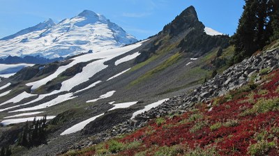
Ptarmigan Ridge
A hike on what is more of a climber's path and often snow-covered well into summer. It's up to 10 miles round trip with 1,300 feet of elevation gain. Enjoy views of Mount Baker and Mount Shuksan. In winter it is a good backcountry ski tour.
getting there
Drive SR-542 east to the Glacier Public Service Center (Ranger Station). In winter, continue 22.5 miles to the uppermost parking lot of the Mount Baker Ski Area (4,250 ft). In summer, continue another 2.5 miles to the Artist Point trailhead and large parking lot (5,100 ft).
During winter and early spring, all cars must carry chains and a snow shovel!
on the trail
10 miles round trip with 1,300 feet of elevation gain
Hike the Ptarmigan Ridge Trail from Artist Point to the base of the Sholes Glacier (5,990). The trail is more of a climber's path than a maintained trail.
Approach & Ascent
Coleman Pinnacle (6,414 ft)
9.0 miles round trip, 2,000 feet of elevation gain, Difficulty: Strenuous 1, Technical 4
Hike the trail on Ptarmigan Ridge west from Artist Point for roughly 2.5 mi. Ascend to the summit of Coleman Pinnacle in its southeast flank. Consider continuing on to Kaiser Peak.
NOTES
- This scramble has a strenuous rating of 1, and a technical rating of 4. While somewhat short, the ~150 feet of scrambling on the pinnacle does have some exposure which explains the higher technical rating.
- Extend your scramble by descending Coleman Pinnacle heading roughly northwest to Kaiser Peak on Lasiocarpa Ridge.
Lasiocarpa Ridge & Kaiser Peak (6,527 ft)
11 miles round Trip, 2,300 feet of elevation gain, Difficulty: Strenuous 1, Technical 3
Hike the Ptarmigan Ridge trail past Coleman Pinnacle, then turn NNW and follow the ridge to the summit. The entire route is above treeline with gorgeous views in every direction.
ski route
13 miles round trip with 2,500 feet of elevation gain, difficulty: M2 Advanced Ski
Climb to Austin Pass and then along Ptarmigan Ridge to ski one of the many options even as far as Coleman Pinnacle or Sholes Glacier.
- Suitable Activities: Backcountry Skiing, Day Hiking, Scrambling, Snowshoeing
- Snowshoeing Category: Intermediate
- Seasons: Year-round
- Weather: View weather forecast
- Difficulty: M2 Advanced Ski, *Varies*
- Length: 10.0 mi
- Elevation Gain: 1,300 ft
- 5,990 ft
-
Land Manager:
Mount Baker-Snoqualmie National Forest
Mount Baker Wilderness, Mount Baker Ranger District (MBSNF)
- Parking Permit Required: Northwest Forest Pass
- Recommended Party Size: 12
- Maximum Party Size: 12
- Maximum Route/Place Capacity: 12
- Green Trails Mount Baker Wilderness Climbing No. 13SX
- USGS Shuksan Arm
- USGS Mt Baker
This is a list of titles that represent the variations of trips you can take at this route/place. This includes side trips, extensions and peak combinations. Not seeing a title that fits your trip? Log in and send us updates, images, or resources.
- Coleman Pinnacle
- Lasiocarpa Ridge
- Kaiser Peak
- Lasiocarpa Ridge & Kaiser Peak
| Name/Description |
|---|
| Coleman Pinnacle Route Map A topo map showing the route from Artist's Point to Coleman Pinnacle and Kaiser Peak. Submitted by Dave Brunner. |
