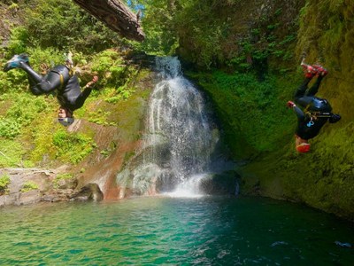
Pin Creek
A short, sunny and scenic canyon with six rappels and four jumps. Highlights include a 35-foot jump from a diving board log into a deep pool and Pin Creek Falls, a popular destination for waterfall photographers. This canyon is typically run from July through September when it is rated v3a3 II.
GETTING THERE
From Randle, drive south on Forest Road 23 for 27 miles. Turn right onto Forest Road 90 and drive 6.4 miles until reaching the bridge over Pin Creek (46.2045, -121.7113). Park the exit vehicles here. To reach the start, drive east on Forest Road 90 for 0.6 mile and turn left onto Forest Road 9085. Drive 0.7 mile to the first switchback in the road.
Approach
Hike roughly northwest through open forest for ~5 min until dropping into Pin Creek. Head downstream and reach the top of the technical section in 5-10 min.
DESCENT
There are six rappels in this canyon and several memorable jumps up to 35 feet. Before jumping, always send someone down to check the depth of the pool and to check for submerged obstacles. The rappels are anchored with either webbing or unlinked bolts.
EXIT
After Pin Creek Falls, head downstream for 5 minutes to reach the bridge. Pass under the bridge and hike up the bank down canyon left to reach the exit vehicles.
EQUIPMENT
Standard canyoning gear including webbing, a wrench, and replacement quick links.
TRIP PROFILE
- Rappels: 6
- Longest Rappel: 60 feet
- Approach: 0.1 mile
- Exit: 0.1 mile
- Time: 4 hours total
NOTES
- This canyon is rated v3a3III from July through September (before fall rains).
- For the most updated information and recent trip reports from the community, visit the Pin Creek web page on Ropewiki.
- Suitable Activities: Canyoning
- Seasons: July, August, September
- Weather: View weather forecast
- Difficulty: Basic Canyon
- Length: 0.7 mi
- Land Manager: Gifford Pinchot National Forest
- Parking Permit Required: Northwest Forest Pass
- Recommended Party Size: 8
- Maximum Party Size: 12
- Maximum Route/Place Capacity: 12
There are no resources for this route/place. Log in and send us updates, images, or resources.
