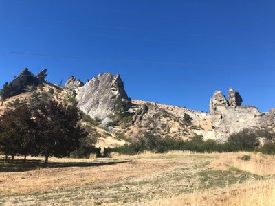
Peshastin Pinnacles
Located east of Leavenworth on Highway 2, Peshastin Pinnacles State Park is a 34-acre day-use park with rock climbing and 1.5 miles of steep hiking trails.
Getting There
Drive SR-2 to east of Leavenworth, ~4.5 miles east of the intersection of SR-2 and SR-97, turn left onto N Dryden Rd from SR-2. In a half mile, turn right into the parking area for Peshastin Pinnacles State Park.
CLIMBING AREAS & ROUTES
- Dinosaur Tower
- Sunset Slab
- Austrian Slab
- Sickle Slab
- Martian Slab
- Church Tower
- Vulture Slab
- Grand Central Tower
- Orchard Rock
Notes
- Guidebook: Leavenworth Rock, 4th ed by Viktor Kramer (2019).
INFORMATION FOR LEADERS
permits
The Mountaineers has a commercial use permit with Washington State Parks for all free and fee-based outings at state parks. Leaders should carry a print or digital copy of our commercial use permit to show rangers they may encounter.
- Suitable Activities: Climbing
- Seasons: Year-round
- Weather: View weather forecast
- Difficulty: Crag Rock Climb, *Varies*, Strenuous 3, Technical 2
- Land Manager: Peshastin Pinnacles State Park
- Parking Permit Required: Discover Pass
- Recommended Party Size: 12
- Maximum Party Size: 20
- Maximum Route/Place Capacity: 12
- see Land Manager
This is a list of titles that represent the variations of trips you can take at this route/place. This includes side trips, extensions and peak combinations. Not seeing a title that fits your trip? Log in and send us updates, images, or resources.
- Peshastin Pinnacles State Park
There are no resources for this route/place. Log in and send us updates, images, or resources.
