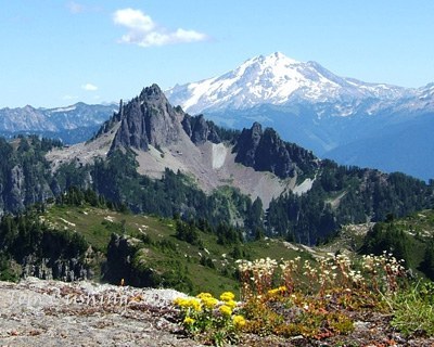
Perry Creek & Mount Forgotten
A moderate to strenuous hike depending on whether your destination is Perry Creek Falls or the alpine meadows below Mount Forgotten.
Getting There
Drive the Mountain Loop Highway east toward Verlot. Turn left at the sign for the Mount Dickerman Trailhead, the trailhead for the Mount Dickerman and Perry Creek Trails (1,800 ft). If you reach Barlow Pass on the highway turnaround, you've gone just a bit too far.
ON THE TRAIL
Perry Creek
8.9 miles round trip, 3,200 feet of elevation gain, 5,250 ft high point
The trail begins in the forest before breaking out into a more open valley. As you traverse on the east side of the creek you'll cross open talus fields and small creeks coming down from Mount Dickerman. Three miles in the trail reaches Perry Creek Falls in 3 miles (3,740 ft). Much of the rushing waterfall is hidden under an overhang so be careful when stepping forward to get a better look. The trail continues across the creek but there is no bridge so be prepared to get your feet wet. If you go in early season it is usually easier to cross a couple hundred feet upstream and catch up with the trail as it starts to switchback up the hill. Views from Forgotten Meadows (5,250 ft) at the top of the ridge are spectacular. Look for Mount Baker, Glacier Peak and more.
Approach & Ascent
Mount Forgotten (6,005 ft)
13.0 miles round trip, 4,500 feet of elevation gain, difficulty: Strenuous 4, Technical 5
Hike the Perry Creek Trail to the ridge near the end of the maintained trail and continue to follow a boot path to a flat area east of Point 5396. A path drops from the flat area to ~5,100 ft and contours Mount Forgotten's southwest ridge on the east along steep slopes. Continue until reaching a basin east of the summit at 5,500 ft with tarn east. From the basin ascend the first gully and beware of rockfall hazard. The summit has three points that run east to west. It was previously believed that the middle point was the highest, which involves some tricky scrambling moves across a wickedly exposed notch (T5). Subsequent measurements have confirmed that the first (east) point reached is in fact the highest, so it is not necessary to cross this gap to claim the summit.
Notes
- The trail passes through the Perry Creek Research Natural Area which is home to 250 different plant species.
- Suitable Activities: Day Hiking, Scrambling
- Seasons: July, August, September, October
- Weather: View weather forecast
- Difficulty: Moderate, Strenuous 4, Technical 5
- Length: 8.0 mi
- Elevation Gain: 3,200 ft
- 5,250 ft
-
Land Manager:
Mount Baker-Snoqualmie National Forest
Perry Creek Research Natural Area, Darrington Ranger District (MBSNF)
- Parking Permit Required: Northwest Forest Pass
- Recommended Party Size: 12
- Maximum Party Size: 12
- Maximum Route/Place Capacity: 12
- Green Trails Mountain Loop Highway No. 111SX
- Green Trails Sloan Peak No. 111
- USGS Bedal
This is a list of titles that represent the variations of trips you can take at this route/place. This includes side trips, extensions and peak combinations. Not seeing a title that fits your trip? Log in and send us updates, images, or resources.
- Perry Creek
- Mount Forgotten
- Mount Forgotten Meadows
There are no resources for this route/place. Log in and send us updates, images, or resources.
