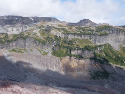
Cowlitz Park Traverse
A remote and beautiful alpine scramble traverse from Paradise to the Fryingpan Creek trailhead that visits several summits in the Cowlitz Park area. This multi-day traverse also includes a ford of the Cowlitz River near its beginnings at the snout of the Cowlitz Glacier.
getting there
Take I-5 to exit 142. Exit to SR 161 and drive south until exiting at SR 512 West.Travel 2-3 mi and take the Puyallup exit (Mount Rainier sign). Drive via Eatonville and SR 706 to the Nisqually entrance to Mount Rainier National Park (approximately 80 mi from Seattle). Pay the entrance fee and drive 19 mi to Paradise at 5,400 ft.
Approach & Ascent
From Paradise, take the trail to Mazama Ridge, then head north towards the Paradise Glacier. Begin scrambling near 6,300 ft by fording Stevens Creek at the most convenient spot and use an ascending traverse to pass north of Point 6649. Descend and traverse in an easterly direction to reach the top of a ridge (6,000 ft) that is adjacent to the eastern fork of Williwakas Creek (the remains of a airplane crash is near this spot). Descend this ridge to reach the saddle (5,800 ft) that is northwest of Point 5884. From this saddle descend steep heather slopes in an easterly direction to reach the crest of an old lateral morraine of the Cowlitz Glacier (5,500 ft).
Carefully proceed through rubble covering a stagnant lobe of the Cowlitz Glacier to reach the most convenient spot to ford the Cowlitz River. This crossing should maintain a respectful distance from where the river emanates from the snout of the glacier. After the crossing ascend the ridge NW of point 5315 (with an incredible waterfall to your left) to reach the crest of the lateral morraine (5,800 ft). Loose a bit of elevation by following this crest to a point (5,700 ft) that is just north of point 5315. From this spot ascend in a mostly northerly direction, becoming north-easterly to reach the saddle between Points 7416 and 6859. Ascend these summits at your choosing, then descend to camp somewhere in Cowlitz Park. Approximate distance and elevation gain for this first day (excluding a visit to Point 7416) is ~8 miles and ~3,000 ft, with the portion on trail at ~3 miles and 1,000 ft.
Descent
Descend through lower Cowlitz Park (passing by points 6276 and 6032) to reach the Wonderland Trail (5,680 ft). Hike the Wonderland Trail through Indian Bar (5,100 ft), over Panhandle Gap (6,760 ft), and through Summerland (5,900 ft) to finally reach the Fryingpan Creek trailhead. Approximate distance and elevation gain for this second day is ~11 miles and ~2,000 ft, with the portion on trail at ~9 miles and ~2000 ft.
Notes
- Ford of the Cowlitz River dictates a best season of September or October.
- This scramble is best done in two days.
- Alpine zone camping limit of 5 dictates the maximum party size.
- Mileage: 12 miles on trail, 7 miles off trail, and 19 miles total.
- Elevation Gain: 3,000 feet on trail, 2,000 feet off trail, and 5,000 feet total.
- Suitable Activities: Scrambling
- Seasons: September, October
- Weather: View weather forecast
- Difficulty: Strenuous 5, Technical 3
- Length: 19.0 None
- Elevation Gain: 5,000 ft
- 6,859 ft
- Land Manager: Mount Rainier National Park
- Parking Permit Required: National Park Entrance Fee
- Recommended Party Size: 5
- Maximum Party Size: 5
- Maximum Route/Place Capacity: 12
- USGS Mt Rainier East
- Green Trails Mt Rainier East No. 270
- Green Trails Mount Rainier Wonderland No. 269SX
There are no resources for this route/place. Log in and send us updates, images, or resources.
