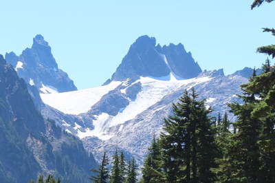
Overcoat Peak
A rarely visited peak in the Alpine Lakes wilderness with a tough approach and some glacier travel on the route.
GETTING THERE
Take Exit 34 off of I-90 and turn north onto 468 Ave SE. In a half mile, turn right onto SE Middle Fork Road (Forest Road 56). Drive 12 miles to the junction with Taylor River Road, turn right onto Forest Road 5620 and drive 5 miles to the Dingford Creek Trailhead (1,500 ft). High clearance vehicles are recommended.
Approach & Ascent
Mountain bike (or hike) 10 miles to ~1 mile before the start of the old Dutch Miller Gap Trail. Cross the Middle Fork Snoqualmie River, and travel up the steep forested slopes to camp at Overcoat Lake. It's ~2 hours of biking to old trailhead and 3-4 hours to Overcoat Lake.
From camp, contour up the benches above and head eastwards towards a notch on the north ridge of Overcoat Peak, which gives access to the upper Overcoat Glacier. Find a snow finger from the glacier to the east face, and climb Class 3 ledges to the summit. A rope and some pro might be advisable here. It's ~4 hours from camp.
Photo by Rob Busack from Tank Lakes on August 31, 2024.
- Suitable Activities: Climbing
- Climbing Category: Basic Alpine
- Seasons: June, July, August, September
- Weather: View weather forecast
- Difficulty: Basic Alpine Climb
- Length: 26.0 mi
- Elevation Gain: 8,000 ft
- 7,432 ft
-
Land Manager:
Mount Baker-Snoqualmie National Forest
Alpine Lakes Wilderness, Snoqualmie Ranger District (MBSNF)
- Parking Permit Required: Northwest Forest Pass
- Recommended Party Size: 6
- Maximum Party Size: 12
- Maximum Route/Place Capacity: 12
- Green Trails Middle Fork Snoqualmie No. 174SX
- Alpine Lakes Wilderness (ALPS)
- USGS Big Snow Mtn
There are no resources for this route/place. Log in and send us updates, images, or resources.
