
Osceola-Carru-Lago-Blackcap-Lost Traverse
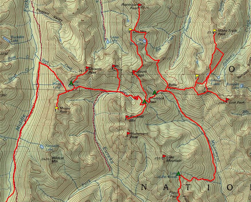
A multi-day, 50+ mile traverse of up to five Top 100 peaks in the beautiful and remote Pasayten Wilderness: Osceola Peak, Mount Carru, Mount Lago, Blackcap Peak and Lost Peak. Beginning at Slate Pass, this traverse is half trail and half cross-country travel with camping at Dorothy Lake and Shellrock Pass.
Getting There
Drive SR 20 east 1.5 miles past Early Winters campground. Turn left and drive 0.4 miles to Mazama. Turn left on Harts Pass Road (No. 9140), which turns into Forest Road 5400 for 20 mi to Harts Pass. Turn right and drive 2 mi to Slate Pass and Buckskin Ridge Trail (No. 498).
SUGGESTED ITINERARY
Day 1: Begin hiking on Trail No. 498 (6,900ft) for 0.6 mi to reach Middle Fork Pasayten Trail (No. 498A). Continue 5.1 mi and take a right on the north spur of Ferguson Lake Trail (No. 474). Hike 3 mi to and make camp at Lake Doris (6,975ft). Scramble Osceola Peak from camp, heading 0.6 mi northeast through open forest. Travel on talus gaining 1,400 feet to the southwest ridge or south face then on to summit (8,587 ft). Return to camp.
Day 2: Break camp and follow Trail No. 474 east for 4.5 mi to the west end and below Shellrock Pass and make camp at the meadows at 6,400 ft. From camp, take the trail east to 7,100 ft before the steep switchbacks. Leave trail and traverse SSW across open grassy, rock basin staying below cliffs. From the base of the next talus slope, stay between cliff trending to the basin on the left and a short north spur on right (north). Take the left (east) edge of the talus heading south to a saddle in the ridge just right (west) of the cliff terminus. Head right (west) and scramble ridge staying on the left side as terrain allows. This will take you to the northeast corner of the summit. Continue on Class 3 to the summit of Blackcap Peak. Return to camp. It's about 6 hours round trip from camp.
Day 3: From camp head east past Shellrock Pass, continuing east descending 1.3 mi to Trail No. 484. Continue east, dropping to Butte Pass (6,900 ft). Lost Peak is essentially a 3 mi ridge run, with the option to climb Pass Butte on the way. Leave the trail heading east and climb over Point 7275 then down to a saddle on the east (7,000 ft). From here, travel on ridge east to crest at 7,700 ft. Begin traversing southeast to the col between Pass Butte and Point 8107. Traverse southeast at 7,800 ft to the base of Lost Peak's prominent northwest ridge. Follow the ridge southeast on to the summit (Class 2, 8,464 ft). Return to camp. It's 12.8 mi round trip from western Shellrock Pass camp.
Day 4: Climb Mount Lago and Mount Carru. From camp, hike west on Trail No. 484A along east fork of Eureka Creek. Look for a red talus gully east of the Carru-Lago saddle. Leave trail here at a creek crossing and head north ascending gully for 400 feet. Traverse right staying below the buttress and above trees to the southwest face then to the west ridge staying on south side to summit Mount Lago (Class 2-3, 8,745 ft). It's about 4 hours from camp.
Return to meadow at the saddle at 7,100 ft. Traverse west through mixed forest and past a rock buttress. Travel northwest directly to the western summit gully. Ascend the gully to a notch 400 feet below the summit gully and follow this gully to ridge and then on to the summit of Mount Caru. To return to camp, return to the meadow at 7,100 ft near the Carru-Lago saddle, then follow the lower accent gully to Mount Lago back to trail and then east on the trail back to camp. It's 8-10 hours round trip.
If your party has sufficient energy, move your camp to Lake Doris or Fred's Lake to minimize the distance traveled on Day 5.
Day 5: Break camp and return to cars. 17 mi, +2,800 ft from Meadows camp, 11.8 mi, + 2100ft from Lake Doris.
TRIP PROFILE
- Day 1: 11.8 mi, +2,100 ft, -2,100 ft to camp. +1,700 ft to Osceola summit. Total: 14.2 mi and 3,800 ft.
- Day 2: 4.5 mi to camp -500 ft, +2,000 ft camp to summit. Total: 7.5 mi and 2,000 ft.
- Day 3: 6.4 mi camp to summit -900 ft, + 3,000 ft. Total: 12.8 mi and 3,900 ft.
- Day 4: Camp to Lago summit +2500 ft. Lago to Carru -1,645 ft, +1,500 ft. Total: 5mi and 4000ft.
- Day 5: 17 mi, +2,800 ft -2,100 ft.
- Trip Grand Total: 57 mi and 16,000 ft
notes
- Guidebook Reference: Summit Routes: Washington's Highest Peaks by Scott Stephenson and Brian Bongiovanni (Alpenbooks Press 2004).
- Other peaks that can be scrambled as part of a Pasayten outing include Wildcat Peak (7,958 ft), Pussycat Peak (7,985 ft), Mount Role (8,096 ft) and Pass Butte (8,140 ft). These don't add much to the mileage, but can push the to elevation gain to 20,000 feet.
- Suitable Activities: Scrambling
- Seasons: June, July, August, September, October
- Weather: View weather forecast
- Difficulty: Strenuous 5, Technical 5
- Length: 57.0 mi
- Elevation Gain: 16,000 ft
- 8,745 ft
-
Land Manager:
Okanogan-Wenatchee National Forests
Pasayten Wilderness, Methow Valley Ranger District (OWNF)
- Parking Permit Required: Northwest Forest Pass
- Recommended Party Size: 6
- Maximum Party Size: 6
- Maximum Route/Place Capacity: 12
- Green Trails Pasayten Peak No. 18
- Green Trails Washington Pass No. 50
- Green Trails Billy Goat Mountain No. 19
- USGS Mt Lago
- USGS Lost Peak
This is a list of titles that represent the variations of trips you can take at this route/place. This includes side trips, extensions and peak combinations. Not seeing a title that fits your trip? Log in and send us updates, images, or resources.
- Lago Slam
- Pasayten Outing
| Name/Description |
|---|
| Paysayten Trip.JPG |