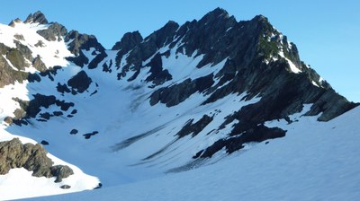
Mount Anderson/Eel Glacier
This is a pleasant glacier trip with excellent views of the Olympic Range and Puget Sound area. Mount Anderson via the Eel Glacier is Grade I, class 3. Times: Trailhead to Camp 7-9 hrs, Camp to Summit 5-7 hrs.
getting there
Drive US-101 to the Dosewallips River Road, just north of Brinnon. Turn onto Dosewallips River Road and drive just over 9 miles to where the road is washed out and park there.
approach
Hike a trail around the washout and continue hinking on the road to the Ranger Station, 5.6 miles. Mountain bikes are a good time-saving option for this section of travel. From the Ranger Station (1,600 ft), take the Dosewallips Trail 1.4 mi to the junction with the West Fork Dosewallips Trail. Take the West Fork Trail to Honeymoon Meadows camp (3,527 ft), 8 mi from the Ranger Station. The Anderson Pass Shelter, located 0.7 mi and 700 feet of elevation gain beyond Honeymoon Meadows, is an alternate campsite. Continue on the West Fork Dosewallips Trail 1.2 mi to Anderson Pass (4,464 ft). Turn right on a trail and ascend to the Anderson Glacier moraine (5,200 ft). Cross the moraine and drop onto the glacier. Rope up here.
ascent
Follow the right side of the glacier to the steep snow finger below Flypaper Pass. Ascend this snow finger to the pass at 6,500 ft. From Flypaper Pass drop 200 feet onto the Eel Glacier and traverse around a rock buttress. Then climb E on the upper Eel Glacier to a saddle just north of the summit. Follow snow and rock south to the summit.
Descent
Descend the climbing route.
trip profile
| SEGMENT | TIME (HOURS) | ELEVATION GAIN (FEET) |
|---|---|---|
| Trailhead to Camp | 7-9 | 2,727 |
| Camp to Summit | 2-3 | 3,794 |
| Summit to Camp | 3-4 | |
| Camp to Trailhead | 5-6 |
notes
- The above route description is meant for a three day trip. To make this a two day trip, camp on the Anderson Glacier moraine. Water is available from a nearby tarn
- There is an additional 11 miles round trip on the approach because of the road washout.
- Best done in spring or early summer, before the snow finger leading to Flypaper Pass melts out.
- Mountain bikes are a good time-saving option for traveling the washed out section of the Dosewallips River Road.
- Suitable Activities: Climbing
- Climbing Category: Basic Alpine
- Seasons: May, June, July, August, September
- Weather: View weather forecast
- Difficulty: Basic Glacier Climb, Basic Experience Climb
- 7,321 ft
-
Land Manager:
Olympic National Park
Olympic Wilderness
- Parking Permit Required: National Park Entrance Fee
- Recommended Party Size: 12
- Maximum Party Size: 12
- Maximum Route/Place Capacity: 12
- USGS Mt Steel
- USGS The Brothers
- Green Trails Olympic Mountains East No. 168S
- Trails Illustrated Olympic National Park
There are no resources for this route/place. Log in and send us updates, images, or resources.
