
Mowich Lake to Westside Road
In summer, this is an incredible one-way trek past some of the most beautiful and least seen sections of Mount Rainier National Park's Wonderland Trail including Golden Lakes, Sunset Park and Klapatche Park. It's 26.4 miles one-way with 4,600 feet of elevation gain. In winter, take advantage of the Westside Road closure for an easy snowshoe or ski trip with gentle uphills with options to cover up to 10 miles.
Emergency closure
As of April 14, 2025, the Fairfax bridge at milepost 11.5 has been closed until further notice. This closes access to Mount Rainier National Park's Mowich Lake and Carbon River entrances. Check WSDOT.com for status.
getting there
For a one-way trip in summer, set up a car shuttle by leaving some cars at Westside Road and continuing to Mowich Lake. In winter, drive to Westside Road.
West Side Road
Drive east on SR-7 (National Park Highway), continuing east when it becomes SR-706. Enter Mount Rainier National Park and one mile from the entrance, turn left (north) on Westside Road. In winter, Westside Road is closed here. In summer, drive 3.2 miles to the trailhead (2,900 ft).
In winter, ALL drivers in the park are required to carry snow chains or equivalent traction devices—this includes those with a 4-wheel or all-wheel drive vehicle.
Mowich Lake
From Enumclaw drive 5 miles west on SR 410 to the small town of Buckley and on the west end of town, turn left (south) onto SR 165. Continue 10 miles through the communities of Carbonado and Wilkeson before crossing the one-lane bridge over the deep Fairfax Gorge on the Carbon River. Just beyond the bridge, turn right onto Mowich Lake Road (Forest Road 79) a narrow road that climbs through a clearcut slope. Drive to the second trailhead at Mowich Lake (4,950 ft).
on the trail
26.4 miles one-way with 4,600 feet of elevation gain, 5,700 ft high point
Beginning at Mowich Lake, this southbound ramble heads downhill 2,300 feet to cross both the north and south branches of the Mowich River, with the South Mowich River camp situated in the middle. This is often an area where you can get your feet wet when the bridges are out or the river is running high, so water footwear is recommended. After getting through the river, head up a gentle grade gaining 2,300 feet to the Golden Lakes, 10.9 miles from the trailhead and a good spot to take a lunch break. However, while this is a beautiful spot with a ranger cabin, wilderness toilet, and several picturesque areas, it is also a haven for mosquitoes depending upon the time of year. Go behind the ranger cabin on the left and sit by the lake on some perfectly situated rocks. There are fewer mosquitoes over here, and you can watch the frogs or fish jump while you eat.
Continue along the Wonderland Trail south, past a ridge filled with huckleberries, to Sunset Park where the bleached trees and colorful wildflowers make for an excellent stage for the main character of Mount Rainier. A short side trip uphill at Sunset Park grants a full and incredible view of the Mount Rainier.
Descend 1,200 feet to the North Puyallup River and the remains of the old bridge destroyed in the 2006 floods. Pause here and look toward the mountain to see a huge gully with several waterfalls fed from the Puyallup Glacier. The views of this gully become more incredible with each switchback up 1,900 feet toward Aurora Peak and Klapache Park. Klapatche Park is a wonderful spot for another break and to watch tadpoles in the lake. Or push on a bit further to St. Andrews Park with its own lake and waterfalls. Another incredible view awaits those who take the side trip up to the view point from St. Andrews Park.
Follow the ridge for a short jaunt, and then descend 1,400 feet to the South Puyallup River Camp with it's beautiful basalt columns in their incredible honeycomb patterns. Once here, leave the Wonderland Trail and head directly to the Westside Road. The trail here has been washed out and can be a bit hard to follow, so be sure to watch for the cairns and stick to the left. Take the Round Pass Trail the last half mile to the road, rather than getting on the road immediately, just for the beauty of it. At the road the Marine Memorial is on the right, and the trail to Gobblers Knob to the left. Follow the road south for about 4 miles to the Westside Road trailhead.
snowshoeing & cross-country skiing
up to 25.6 miles round trip and up to 2,800 feet of elevation gain
Westside Road in Mount Rainier National Park is closed in winter at the junction with Highway 706, transforming this road into a winter playground when the snow levels cooperate. From here, follow the road as it parallels Tahoma Creek. Depending on snow levels, you may need to walk before you can ski or snowshoe. One possible turnaround point is the summer trailhead, located 3.2 miles from the junction with the Paradise-Nisqually Road. At 4.0 miles, there is a footbridge crossing Tahoma Creek, and at 5.0 miles, a turnoff points the way to Round Pass, Gobblers Knob, and Mount Beljica. The entire road is 12.3 miles one way from its intersection with SR-706 to Klapatche Ridge.
- Check avalanche conditions before you visit—the first mile of the Westside Road has avalanche risk, as do miles further. This route is best done when avalanche risks are lower. Rockfall is also a hazard in the first mile of Westside Road.
Winter Scrambling
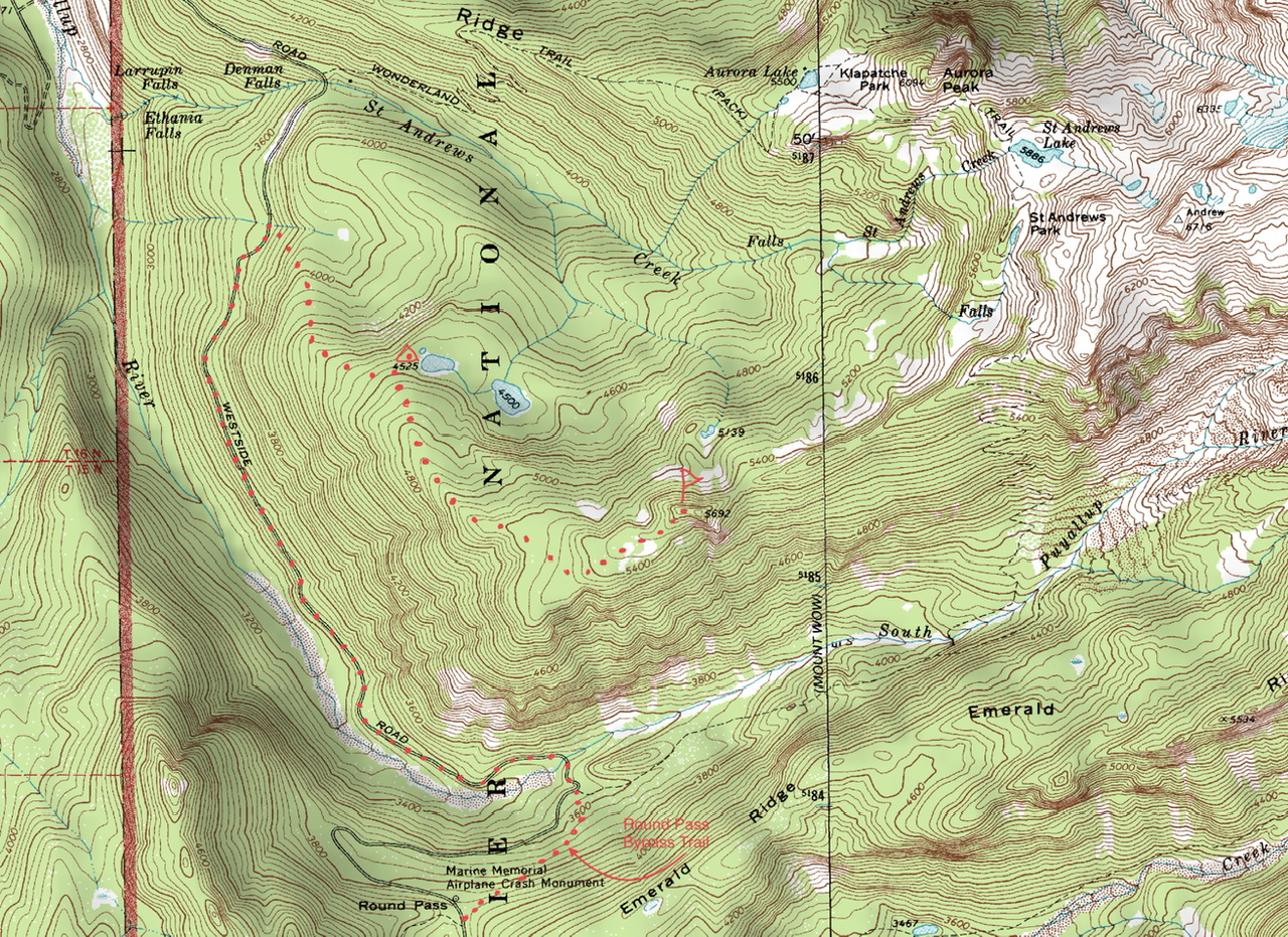
Point 5692
22 miles round trip, 5,000 feet of elevation gain
Hike the West Side Road north until reaching the intermittent stream that is ~0.5 mi south of the Klapatchie Ridge Trailhead (3,600 feet). From here ascend cross country in a southeasterly direction to reach campsites near Lake 4525. From the campsite ascend SSE then turn east at ~5,000 feet to reach the summit. Return by retracing the ascent route.
- Suitable Activities: Backpacking, Cross-country Skiing, Day Hiking, Snowshoeing
- Seasons: Year-round
- Weather: View weather forecast
- Difficulty: Strenuous/Very Strenuous, U-XC 2 Advanced Beginner Ungroomed
- Length: 26.4 mi
- Elevation Gain: 4,600 ft
- 5,700 ft
- Land Manager: Mount Rainier National Park
- Parking Permit Required: National Park Entrance Fee
- Recommended Party Size: 12
- Maximum Party Size: 12
- Maximum Route/Place Capacity: 12
- Green Trails Mount Rainier Wonderland No. 269SX
This is a list of titles that represent the variations of trips you can take at this route/place. This includes side trips, extensions and peak combinations. Not seeing a title that fits your trip? Log in and send us updates, images, or resources.
- Wonderland Trail: Mowich Lake to Westside Road
- Westside Road
- Point 5692
| Name/Description |
|---|
| Topo Map of the Route to Point 5692 in Mount Rainier National Park Topo map of the route to Point 5692 in Mount Rainier National Park by Dave Morgan, Jan 2, 2023. |