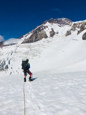
Mount Rainier/Sunset Ridge
A long and strenuous ridge climb of moderate technical difficulty depending on conditions. The route separates the upper Mowich Face and Sunset Amphitheater and meanders through a series of steep gullies and snowfields.
GETTING THERE
From SR-7 in Elbe, turn east onto SR-706, both known as the National Park Highway. Continue through the Nisqually Entrance of Mount Rainier National Park. Be prepared to pay the fee just after entering the park. One mile from the entrance, turn left (north) on Westside Road and drive to the gate (2,900 ft).
APPROACH
Walk the road ~3.5 miles to Round Pass. Hike the South Puyallup River Trail to where the trail meets the Wonderland Trail. Hike the Wonderland Trail to Saint Andrews Park, leave the trail and travel north. Climb up through alpine meadows to the Puyallup Cleaver passing Tokaloo Spire. Leave the cleaver at 8,500 ft and traverse north across the Puyallup and South Mowich glaciers. Ascend a steep snow gully to a small bergschrund and good camping. It's also possible to camp near the Puyallup Cleaver, but it makes for a longer summit day.
ASCENT ROUTE
Bypass the bergschrund on 45° slopes. Ascend a series of steep gullies and open faces with angles 50-55°. At 12,800 ft the ridge forces climbers out onto the upper Mowich Face. Traverse onto the face and ascend the steep snow or ice to 13,200 ft where the route regains the ridge. Climb the ridge to Liberty Cap and from there to the summit.
DESCENT ROUTE
Carryover and descend the Disappointment Cleaver route with prearranged car shuttle. If done early season, a party could camp on the Puyallup Cleaver and descend the Tahoma Glacier route.
EQUIPMENT
Standard glacier gear, pickets, and ice screws.
INFORMATION FOR LEADERS
PERMITS
A climbing permit is required for trips on glaciers and/or above 10,000 ft. Fees apply. Check with Mount Rainier National Park (land manger link below) to be sure you have the required camping and climbing permits.
- Suitable Activities: Climbing
- Climbing Category: Intermediate Alpine
- Seasons: June, July, August
- Weather: View weather forecast
- Difficulty: Intermediate Mountaineering Climb
- Length: 16.0 mi
- Elevation Gain: 11,500 ft
- 14,411 ft
- Land Manager: Mount Rainier National Park
- Parking Permit Required: National Park Entrance Fee
- Recommended Party Size: 6
- Maximum Party Size: 12
- Maximum Route/Place Capacity: 12
- Green Trails Mount Rainier Wonderland No. 269SX
- USGS Mount Wow
- USGS Mt Rainier West
- USGS Mt Rainier East
This is a list of titles that represent the variations of trips you can take at this route/place. This includes side trips, extensions and peak combinations. Not seeing a title that fits your trip? Log in and send us updates, images, or resources.
- Mount Rainier/Mowich Face
There are no resources for this route/place. Log in and send us updates, images, or resources.
