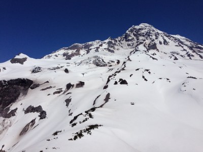
Mount Rainier/Success Cleaver
A remote climb on the southwest slope of Mount Rainier with intimate views of the South Tahoma and Kautz Glaciers. With no well defined destination, an elevation of around 8,000 ft on the cleaver is a convenient scramble trip end point. Climbers continue up Success Cleaver, over to Kautz Cleaver and on to the summit.
Getting There
From the Nisqually entrance of Mount Rainier National Park, drive 1 mi to the West Side Road, turn left and take it as far as it is open, barricaded at Dry Falls, 2,840 ft, in 2015, stopping at the Tahoma Creek Trailhead (3,200 ft and 4.7 mi. from the start of the West Side Road) if you can drive that far.
APPROACh
Walk up the road to the Tahoma Creek Trail if needed. Hike the Tahoma Creek Trail for 2.0 miles to reach the junction with the Wonderland Trail at ~4,300 ft. Head south on the Wonderland Trail which shortly crosses the Tahoma Creek suspension bridge. Continue for 1.7 miles to the Mirror Lakes Trail junction at ~5,300 ft near Indian Henry's Hunting Ground. Follow the Mirror Lakes Trail for 1.2 miles until it fades into a boot track as it reaches the basin between Copper Peak and Pyramid Peak at an elevation of ~5,600 ft.
Scramble route
Scramble cross country through the southwest and west slopes of Pyramid Peak between roughly 6,000 ft and 6,300 ft elevation to reach Point 6631, which is north of Pyramid Peak. Descend NNE a short distance off Point 6631 to reach a saddle at ~6,400 ft, then begin scrambling Success Cleaver proper using whatever route affords the easiest progress. With no well defined destination, ~8,000 ft elevation is a convenient end point for your trip. To this high point, it's 16.0 miles round trip and 5,400 feet of elevation gain.
climbing route
Scramble Success Cleaver proper using whatever route affords the easiest progress. Continue upwards until it is possible to ascend right up steep chutes onto the Kautz Cleaver at about 12,600 ft. Once on the Kautz Cleaver, continue up to Point Success (14,158 ft) and then on to the summit, Columbia Crest, at 14,416 ft.
The early season climbing is Class 3 rock and steep snow. Later in the season, the route traverses steep, exposed scree slopes. The final rock band to the summit is low Class 5. It's 25.0 miles round trip and 11,500 feet of elevation gain.
DESCENT ROUTE
- Descend the climb/scramble route.
- If you climb to the summit, consider a carry-over and descend the Disappointment Cleaver route.
NOTES
- The Tahoma Creek Trail is closed due to flash flooding, but is passable. The flooding is due to sudden releases from the glacier. Familiarize yourself with warning sounds from the flooding and be prepared to seek refuge on high ground.
- Indian Henry's Hunting Ground and the Mirror Lakes Trail may also be reached by the Kautz Creek Trail, west of Longmire, or the Wonderland Trail from Longmire.
INFORMATION FOR LEADERS
PERMITS
A climbing permit is required for trips on glaciers and/or above 10,000 ft. Fees apply. Check with Mount Rainier National Park (land manger link below) to be sure you have the required camping and climbing permits.
- Suitable Activities: Climbing, Scrambling
- Climbing Category: Basic Alpine
- Seasons: May, June, July, August, September, October
- Weather: View weather forecast
- Difficulty: Strenuous 5, Technical 2, Basic Alpine Climb
- Length: 25.0 mi
- Elevation Gain: 11,500 ft
- 14,416 ft
- Land Manager: Mount Rainier National Park
- Parking Permit Required: National Park Entrance Fee
- Recommended Party Size: 12
- Maximum Party Size: 12
- Maximum Route/Place Capacity: 12
- USGS Mt Rainier West
- USGS Mount Wow
- Green Trails Mount Rainier Wonderland No. 269SX
This is a list of titles that represent the variations of trips you can take at this route/place. This includes side trips, extensions and peak combinations. Not seeing a title that fits your trip? Log in and send us updates, images, or resources.
- Success Cleaver
There are no resources for this route/place. Log in and send us updates, images, or resources.
