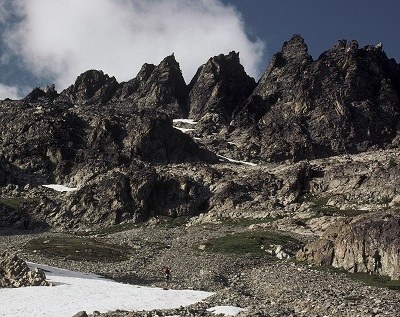
Mount Maude & Seven Fingered Jack
Scramble one or two peaks in the Glacier Peak Wilderness's Entiat Mountains. Mount Maude is the 15th highest and Seven Fingered Jack is the 12th highest peak in Washington and has a great vista of Mount Fernow and Bonanza Peaks, 6th and 8th highest, respectively. The scramble routes are long but fun, and are about half on-trail and half off-trail.
getting there
From US-2/US-97, turn northeast on SR-207. Drive 5.0 miles and then turn left on Forest Road 6200 (Chiwawa River Road). Drive 22 miles, turn right on Forest Road 6211, and continue 2.5 mi to the Phelps Creek Trailhead (3,500 ft).
approach
Travel about 3 miles on the Phelps Creek Trail to Leroy Creek. Leroy Creek is the third major creek to cross the trail and is the most challenging to cross. The flow volume and current are often high until August. Crossing Leroy Creek may be the crux move of the trip.
Once across Leroy Creek, leave the Phelps Creek Trail and turn right (northeast) onto the Leroy Creek trail. This is not a maintained trail, but it is in reasonably good condition. Leroy Creek will be on your right for the rest of the trip. The trail is relatively steep for about 1.5 hours of travel and then opens to a small meadow. Continue past the meadow and through trees to Leroy Creek basin, a large open area. There are established campsites near the trail and near water.
ascent
Mount Maude (9,082 ft)
From the meadows in Leroy Basin, follow the trail southward to the 6,840-foot saddle southwest of Mount Maude. Leave the trail and hike east up the broad ridge and meet the south ridge of Mount Maude at 7,700 ft. Follow that over easy terrain to the summit.
Seven Fingered Jack (9,100 ft)
Seven Fingered Jack is northeast of Leroy Creek basin and is clearly visible from the basin. When first leaving Leroy Creek Basin, two parallel routes are possible. One is to ascend a rock gully to the lower southwest slope of the mountain. The other is to stay on a gentle ridge to the right of the rock gully. The two routes converge in a flat area where the broad and rocky southwest slope begins.
Travel slightly left and up, choosing your the best route. There are several routes to travel up the southwest slope to the summit rocks. If you encounter any steep areas, they can be passed on the right or on the left without difficulty. When you reach the end of the slope and approach the jagged peaks, travel to the left to the true summit. Routefinding is not difficult if visibility is good. Time from basin to summit is about three hours.
notes
- May also be easily approached from Ice Lakes.
- Car camping is recommended.
- Suitable Activities: Scrambling
- Seasons: July, August, September
- Weather: View weather forecast
- Difficulty: Strenuous 5, Technical 4
- Length: 14.0 mi
- Elevation Gain: 5,600 ft
- 9,100 ft
-
Land Manager:
Okanogan-Wenatchee National Forests
Glacier Peak Wilderness, Wenatchee River Ranger District (OWNF)
- Parking Permit Required: Northwest Forest Pass
- Recommended Party Size: 12
- Maximum Party Size: 12
- Maximum Route/Place Capacity: 12
- USGS Holden
- USGS Trinity
- Green Trails Holden No. 113
- Trails Illustrated Glacier Peak Wilderness
- Green Trails North Cascades Lake Chelan No. 114SX
This is a list of titles that represent the variations of trips you can take at this route/place. This includes side trips, extensions and peak combinations. Not seeing a title that fits your trip? Log in and send us updates, images, or resources.
- Mount Maude
- Seven Fingered Jack
There are no resources for this route/place. Log in and send us updates, images, or resources.
