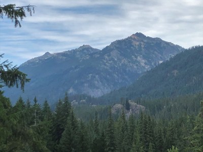
Mount Jerry Garcia
A challenging and strenuous rock scramble of 23 miles with 4,900 feet of elevation gain in the Alpine Lakes Wilderness. The peak is just east of Deadhead Lake and, though not officially named, is known by both Mount Jerry Garcia and Deadhead Peak. Camp at Waptus Lake for two nights, or just one night if your party is fast and okay with a long summit day.
getting there
Take Exit 80 (Roslyn/Salmon la Sac) off of I-90. Turn left (north) on SR-903/Salmon la Sac Road and continue 16.8 miles through Roslyn and past Cle Elum Lake. At the fork with Forest Road 46, stay right and continue on Salmon la Sac Road for ~2 miles to the trailhead and campground.
approach & ascent
From the Cooper River Trailhead, hike the Waptus River Trail 8 miles to plentiful camping at the souheast end of Waptus Lake. In early August expect some mosquitoes and biting flies in camp and on the upper half of the trail.
From camp, continue on Waptus River Trail ~0.5 miles west to the junction with Spade Lake Trail. Ascend the Spade Lake Trail until it veers west at about 4,480 ft, then proceed east off-trail in a rising traverse, passing just above the apex of a vine maple or slide alder gully. Take the path of least resistance eastward, through forest and rocky meadows, until you reach the Deadhead Lake outlet stream, ~0.25 mile away. Cross the Deadhead Lake outlet stream anywhere below 5,000 ft, then travel northeast to ~5,000 ft, then due east on the slight east-west ridge just below the “S” curve of the outlet stream. If you cross the stream at 4,780 ft there is a nice 20-foot waterfall with a waist-deep pool below it.
At ~5,200 ft, turn north and scramble 30 feet of moderately steep “Technical 4” rock scrambling. Continue up the south ridge. At ~5,800 ft a rock face is directly ahead and above, and at ~5,840 ft there may be an opportunity to move west onto steep rock and dirt below the face—instead, move east as needed to continue ascending moderate terrain around and above the rock face. There are two 40-50-foot rock outcrops at the summit. The north one is higher by ~10 feet but is obscured by the south one (when approaching from the south). Skirt below the west face of both rock outcrops on steep heather, then scramble up the rocky north “ridge” of the north outcrop ("Technical 4/5" rock scrambling).
Alternate Route
For more off-trail adventure, ascend the south slope from the southeast end of Waptus Lake, skipping the Spade Lake Trail and eastward traverse.
Descent
Reverse the ascent route or head directly down the south slope back to camp.
It may be feasible to descend to Deadhead Lake and then follow the outlet stream back to the traverse. It also might be possible to descend a gully on the east slope to the Spinola Creek Trail and thence back to camp.
Trip Profile
| SEGMENT | TIME (HR) | Distance (miles) | ELEVATION GAIN (FT) |
|---|---|---|---|
| Trailhead to Camp | 4.5 | 8.5 | +1,000, -400 |
| Camp to Summit | 4.5 | 2.5 | +3,500 |
| Summit to Camp | 3.5 | 2.5 | -3,500 |
| Camp to Trailhead | 4.0 | 8.5 | +400, -1,000 |
- Suitable Activities: Scrambling
- Seasons: June, July, August, September, October
- Weather: View weather forecast
- Difficulty: Strenuous 5, Technical 4
- Length: 23.0 mi
- Elevation Gain: 4,900 ft
- 6,537 ft
-
Land Manager:
Okanogan-Wenatchee National Forests
Alpine Lakes Wilderness, Cle Elum Ranger District (OWNF)
- Parking Permit Required: Northwest Forest Pass
- Recommended Party Size: 8
- Maximum Party Size: 12
- Maximum Route/Place Capacity: 12
- Green Trails Alpine Lakes East (Stuart Range) No. 208SX
- Green Trails Alpine Lakes West (Stevens Pass) No. 176S
- Green Trails Stevens Pass No. 176
- Green Trails Kachess Lake No. 208
- USGS Davis Peak
- USGS Polallie Ridge
- USGS Mt Daniel
There are no resources for this route/place. Log in and send us updates, images, or resources.
