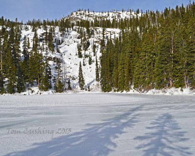
Merritt & Lost Lakes
A moderate 6 mile day hike or snowshoe up to a small alpine lake in the heart of the Central Cascades near Stevens Pass.
Getting There
Drive US-2 to 11.3 miles east of Stevens Pass or 23.6 miles west of Leavenworth and turn north onto Forest Road 657. Drive 1.6 miles to the road's end and trailhead (3,100 ft).
On the Trail
Merritt Lake
6 miles round trip, 1,900 feet of elevation gain, 5,000 ft high point
Hike the Merritt Lake Trail 3 miles to Merritt Lake.
Lost Lake
9 miles round trip, 3,170 feet of elevation gain, 5,600 ft high point
From Merritt Lake, continue 1.5 mile to Lost Lake.
Notes
- Trips can be extended by hiking east on the Nason Ridge Trail to Alpine Lookout or west to Crescent Lake.
- Suitable Activities: Day Hiking, Snowshoeing
- Snowshoeing Category: Intermediate
- Seasons: Year-round
- Weather: View weather forecast
- View avalanche forecast.
- Difficulty: Moderate
- Length: 6.0 mi
- Elevation Gain: 2,000 ft
- 5,000 ft
-
Land Manager:
Okanogan-Wenatchee National Forests
Wenatchee River Ranger District (OWNF)
- Parking Permit Required: Northwest Forest Pass
- Recommended Party Size: 12
- Maximum Party Size: 12
- Maximum Route/Place Capacity: 12
- Green Trails Alpine Lakes East (Stuart Range) No. 208SX
This is a list of titles that represent the variations of trips you can take at this route/place. This includes side trips, extensions and peak combinations. Not seeing a title that fits your trip? Log in and send us updates, images, or resources.
- Merritt Lake
- Lost Lake
- Crescent Lake
- Merritt & Crescent Lakes
- Alpine Lookout
- Merritt Lake & Alpine Lookout
There are no resources for this route/place. Log in and send us updates, images, or resources.
